What we won’t see this Bank Holiday weekend: Number one, a heatwave. Temperatures this weekend look to be around 17 to 22 Celsius with a few degrees higher possible in the sunnier spots. In the sunshine with light winds that should feel pleasant enough for most people but it will soon cool off in the evenings. Number two, a total washout. It looks a bit mixed with lots of showers on Sunday and more in the north on Monday. North Sea coasts will see more cloud and rain at times with a breeze off the sea but there will be breaks inbetween. So there is hope of some fair weather but you would be lucky to stay dry for the whole of the long weekend.
After a very soggy midweek, there should be something drier for the start of the late May Bank Holiday weekend. Friday afternoon and evening looks fine with any cloud cover breaking up, giving more bright spells and only light winds. There will only be the odd lingering shower with a bit more cloud in the far northwest. This is due to a fading front bringing more cloud and dampness to coastal areas. If you are camping in England and Wales Friday night looks a bit cool inland with temperatures falling down into single figures. Patchy cloud over Northern Ireland and Scotland could save the temperatures, staying at around 9 to 12C overnight.
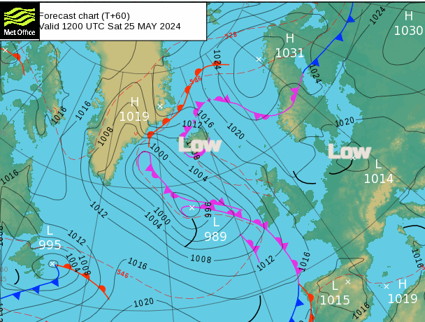
For most of the UK, Saturday starts off cool, dry, sunny and calm. There are a few things to watch on Saturday. A low pressure over Germany and Poland will throw rain and cloud cross the North Sea towards eastern England. A complex system in the north Atlantic will edge closer to Ireland during Saturday introducing showery rain from the west. In between there will be a lot of fine, bright even sunny weather for the UK. The air is not especially warm but in sheltered sunshine it will feel pleasant as temperatures rise into the high teens or low twenties Celsius. North Sea coasts of England could feel a bit cooler in the easterly breeze as the cloud arrives and any showery rain. The southeasterly breeze will pickup for Cornwall and Devon as high cloud arrives from the Alntatic and there will be a bit more of a breeze for Northern Ireland through the afternoon.
There will be a squeeze through the day with showery rain from the Atlantic moving over SW England and into southern Wales. It could reach across to the Isle of Wight by late evening. From the east, the rain and cloud over the North Sea will edge northwards towards northeast England and eastern Scotland as the easterly wind picks up
Into the evening there will still be a lot of fine, bright weather around. Just one or two inland showers over higher ground but it won’t feel warm.
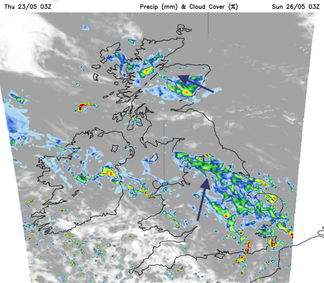
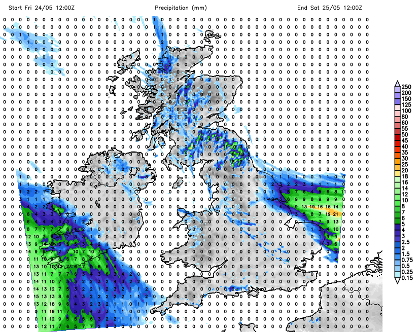
The whole lot then rotates over the UK. The east coast rain moves across northern mainland Scotland as the showery rain band from the southwest swings over the Midlands and southeast England overnight. By Sunday morning it could be over East Anglia, northern Egnland reaching across North Wales into Northern Ireland. To the north of this, there will be a lot of cloud with patchy rain, the west coast of Scotland should see sunny spells in the easterly flow. To the south of the rain band it will be brighter with sunny spells but a scattering of sharp showers too. These will develop during the day, like a rash over the southern half of Britain. It will be hit and miss as always with showers, some people will miss them and have a fine Sunday, others could catch a hefty downpour. In the light southwesterly flow temperatures will be similar but could reach 23 or 24C in the sunshine.
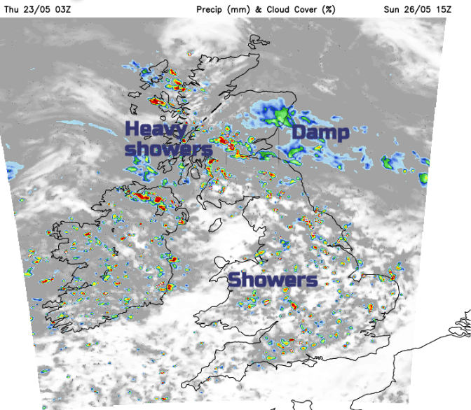
With a more easterly flow and more cloud parts of Scotland will feel cooler as could northern counties of Northern Ireland with outbreaks of rain but very light winds. There will be plenty of showers over Ireland and around the border, across northern England into southern Scotland with clusters developing and some locations seeing longer wet spells.
It makes planning anything outside a bit tricky. Really on Sunday, you will have to watch the radar and see where the showers are and how they are moving (turn Animation On)
The focus of the showers drifts eastwards over Britain into Sunday evening as the old frontal bands creep eastwards over Britain. Perhaps the Peak District and northeastern counties of England will see more showers later in the day. Showery outbreaks continue for Northern Ireland and Scotland as Wales, Cumbria and southern England see fewer showers by Sunday evening.
Bank Holiday Monday
Again there is a risk of showers with bright spells in between. Southern Britain looks to miss most of the showers but the far northwest of Scotland and Northern Ireland look wet early on. The current forecast shows a showery morning for Northern Ireland, Scotland and northern England, again with bright spells inbetween.
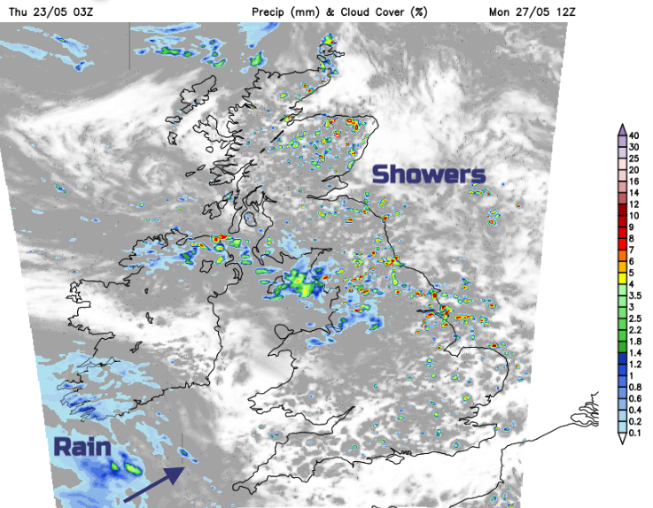
There will be early well-scattered showers for Wales and the rest of England but it becomes drier as the focus for showers heads towards the North Sea
There is another frontal wave showing itself, moving towards Cornwall later on Monday. Hopefully, that will stay away in daylight hours but it looks to subdue the shower activity ahead of it over the West Country and Wales . There will be more of a westerly breeze on Monday so the air won’t feel really warm but again in sheltered sunshine it will feel pleasant. UV levels are higher now and the tree pollen levels have been moderate.
It’s a mixed weekend but there will be good bright or sunny spells, you just have to watch out for the showers.
Loading recent activity...