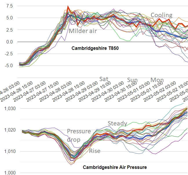
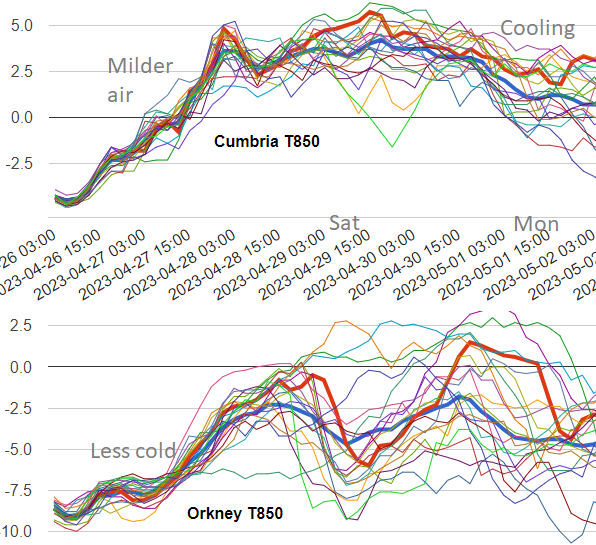
It's tricky to pin down the details at this stage but it will feel milder later this week and pressure will rise on Saturday. A bit of a mixed bag but warm in any sunny spells.
The early May Bank Holiday weekend is coming up. The air will become milder in the run-up to the long weekend. It has felt a bit nippy at times this week but as so often at this time of year, how it will feel depends on the sunshine amounts. Pressure does rise sharply after a low pressure moves through early on Friday and then steadies at the weekend. However, the weather remains quite unsettled. Some will be lucky and see fair weather with lengthy dry spells but others will keep more cloud and see outbreaks of rain.
Temperatures will be in the mid to high teens across the UK but should edge up to towards 20C, even the low 20sC for any sunny, sheltered parts of England. However, pinning those down is a little tricky at this stage. There will be some rain, which looks to linger over parts of Scotland. There will also be showery downpours with bright spells in between. Some of these showers will be heavy and slow-moving, even thundery at the weekend, so it really is a mixed bag.
Bank Holiday Monday actually is the 1st of May this year but the overall weekend weather is very much like April. The uncertainty of showers, changes in temperature from warm, strong sunshine to a bit of a nip in the air as it clouds over and a shower passes by.
Forecasters often get a lot of grief about a forecast like this, “you are including everything, covering all bases”. We can’t say with certainty about the detail yet but there is a picture of each day to be told. And then on the day, this kind of situation is when people exclaim “What is going on with the weather today, it's crazy!”. One minute it is warm and sunny, you’ve headed out of the door feeling happy and summery. The next, there is a blustery wind, dark ominous clouds and you are wishing you’d brought a coat and even a jumper, rather than thinking about the bits you’ve missed when putting on sunscreen. Worse still, you can get caught in a hefty downpour. It will be worth keeping an eye on the Netweather Radar as the showers develop. It’s a UK Bank Holiday weekend, so hope for fine weather, prepare for something else.
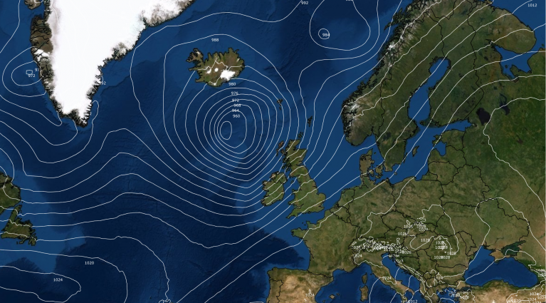
Low pressure will be pulling away eastwards over the North Sea on Friday. Around that there will be a cool breeze and more cloud. Most of the patchy rain over England will fade by Friday evening with breaks appearing in the cloud and Wales looks fair. East Anglia could feel mild into the evening with temperatures of 16 or 17C early on. It will feel cooler quickly for northern Britain with a band of rain moving down over mainland northern Scotland.
This band remains during the weekend with more cloud and outbreaks of rain for northern Scotland. The band dips along the west coast into Northern Ireland on Saturday and there is still the chance of rain on Sunday. A new front looks to move in over Ireland early on Sunday and that brings more cloud and rain, with an unsettled picture across the UK. There could also be a scattering of heavy, even thundery showers. On Saturday they look to affect Northern Ireland, Wales, SW England and the West Midlands into northern England. More areas could see the showers on Sunday although SE England and East Anglia might escape dry.
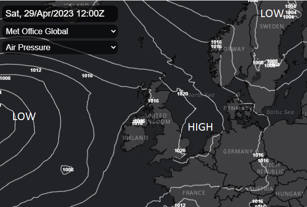
It looks like eastern areas and the far north could still be seeing showery outbreaks of rain on Monday but more places might become drier and brighter. Pressure is trying to rise again and will slowly quash the shower activity. Scotland and northeast England could still be in cooler air with a breeze from the north or northeast. The North Sea is still chilly at this time of year. What for the end of May Bank Holiday when it might be 2 degrees less cold.
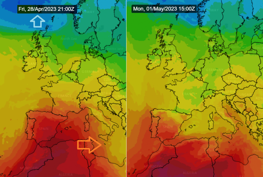
For those heading further afield this weekend, Portugal and southern Spain have seen temperatures over 30 to 35C already this week with more to come in the next day or so. It does look like a cold front will pass eastwards over Iberia on Saturday and ease the heat and highest temperatures. Here in the UK, we won’t see this hot, dry, dusty north African air. The highest temperatures will only appear where there are lengthy cloud breaks and good sunshine.
Belfast should see a warm 18C on Saturday with light winds and bright skies. Rain will arrive overnight and leave a cloudy more unsettled Sunday. If the winds do shift to a northerly by Bank holiday Monday it will feel cooler again.
Manchester will have a similar story, mild at 17C on Saturday but with increasing cloud and rain by the evening. Sunday looks unsettled at 16C and Monday could feel cooler with a chilly Monday night. Edinburgh looks to have a cool easterly wind on Saturday and will struggle at 8C with a bit of rain. Sunday looks brighter and will feel milder at 15C with hardly any breeze but the cool air could return on Monday in a north to north-easterly wind.
Cardiff should see fair, bright days and feel pleasantly warm at 18C on Saturday and Sunday but as the westerly breeze picks up Monday might feel cooler at only 12C with more cloud and a bit of rain in the morning. London’s temperatures are harder to pin down. With more cloud it could be 17 or 18C but if the sunshine breaks through they might pop up to 22C. For Bank Holiday Monday in a more westerly flow, southeast and eastern England should do well with brighter skies.
Loading recent activity...