Severe thunderstorms with powerful tornadoes continue to hit parts of the Deep South of the United States this weekend, producing hail the size of golf balls but more dangerous has been the number of violent tornadoes they are producing too.
At least 26 people died in the southern states of Mississippi and Alabama on Friday after a number of powerful tornadoes ripped through rural communities after dark, razing buildings to the ground, throwing cars and even buses around like toys and plunging homes into darkness.
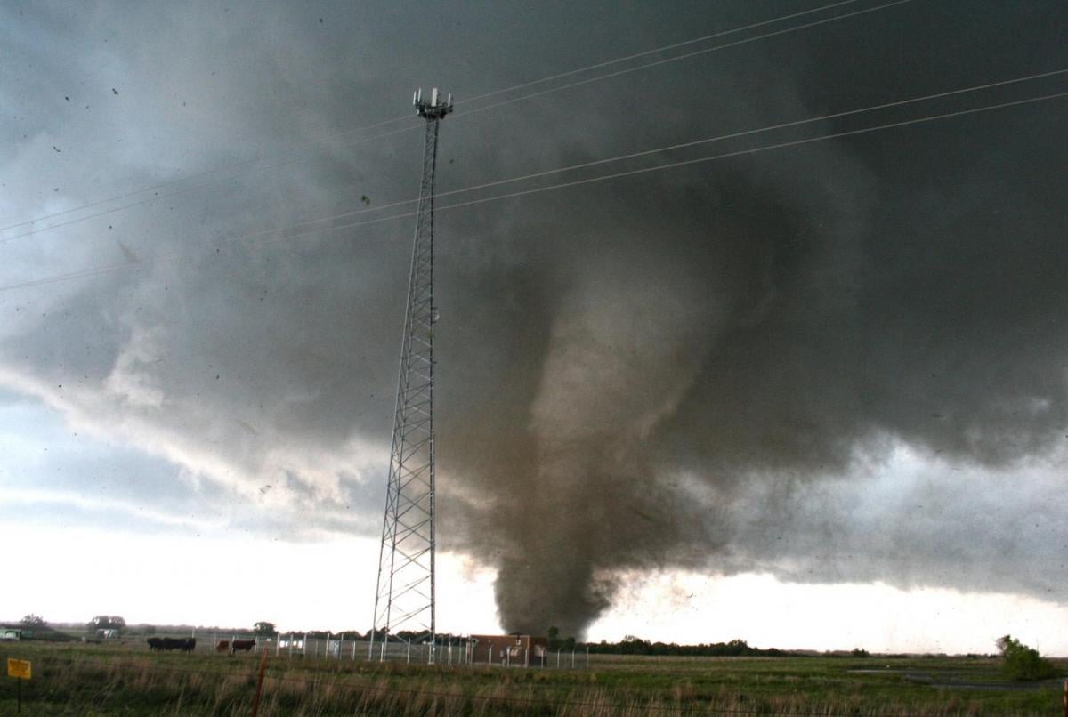
The worst impacts were spawned from a storm that carved a devastating path northeastward across the rural towns of Silver City and Rolling Fork, about 60 miles northeast of Jackson, Mississippi. The twister flattened entire blocks, obliterated houses, ripped a steeple off a church and toppled a municipal water tower.
This morning images started coming through on Twitter of more lives and property destroyed by a tornado ripping through communities in central Georgia early Sunday local time. Drone video near West Point in Troup County shows major damage to houses with whole roofs ripped off and external walls missing, trees ripped down to short stumps and other structures destroyed.
So why are parts of the USA so prone to these deadly tornadoes?
Although the United Kingdom has more tornadoes per area than any other country in the world, given the shear size of the USA, it sees more tornadoes than any other country in the world. It averages about 1,250 twisters a year. The UK sees around 35 each year, Canada, sees about 100 tornadoes per year. Violent tornadoes occur more often in the USA than any other country too, but why is this?
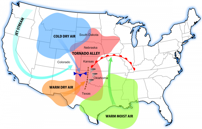
Most tornadoes in the USA occur east of the Rockies – particularly over the Great Plains, Midwest, Mississippi Valley and southern states further east. There are two areas that are particularly prone to tornadoes. ‘Tornado Alley’ is the most famous, a broad area that stretches north-south between Texas and Canada, with the core of the area centred on north Texas, Oklahoma and Kansas. The other area is know as Dixie Alley, which is where Friday night’s devastating tornado developed, it includes the southern states of Mississippi, Alabama and Florida.
But the reason why these parts of the USA see so many and, sometimes, such violent tornadoes is due to its unique geography. Warm moist air from the Gulf of Mexico, that fuels the powerful tornadic supercell thunderstorms, easily advects north all the way to Canada east of the Rockies across the centre of the USA, with few topographic barriers in the way.
However, warm and moist air from the Gulf of Mexico is just one part of the jigsaw created by the topography of the USA that leads to severe thunderstorms. There are three key ingredients necessary for the kind of severe thunderstorm that can produce tornadoes:
Once the above three ingredients are in place the stage is set for severe thunderstorms to develop. However, one final jigsaw to get them going is a forcing mechanism. This can occur in a number of ways. These include
To get the rotation in a storm, for it to become a supercell and perhaps produce a tornado, there needs to be winds at different speeds and directions at different levels of the atmosphere where the storm is. For supercells to form, with a rotating mesocyclone that can produce tornadoes (i.e. a strong rotating updraft into the storm) – usually winds increase and veer with height – creating what is known as strong vertical wind shear. The ideal set-up for tornadoes in Tornado and Dixie Alleys is a moist surface wind from the south, southeast or east with winds veering southwesterly or westerly and increasing with speed aloft. This change in direction and increase in speed of winds aloft combined with a strong updraft of warm air ingested into a thunderstorm causes a corkscrew effect to the rapidly rising air.
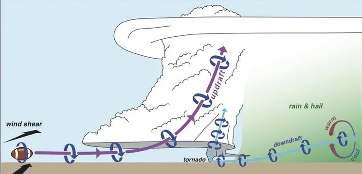
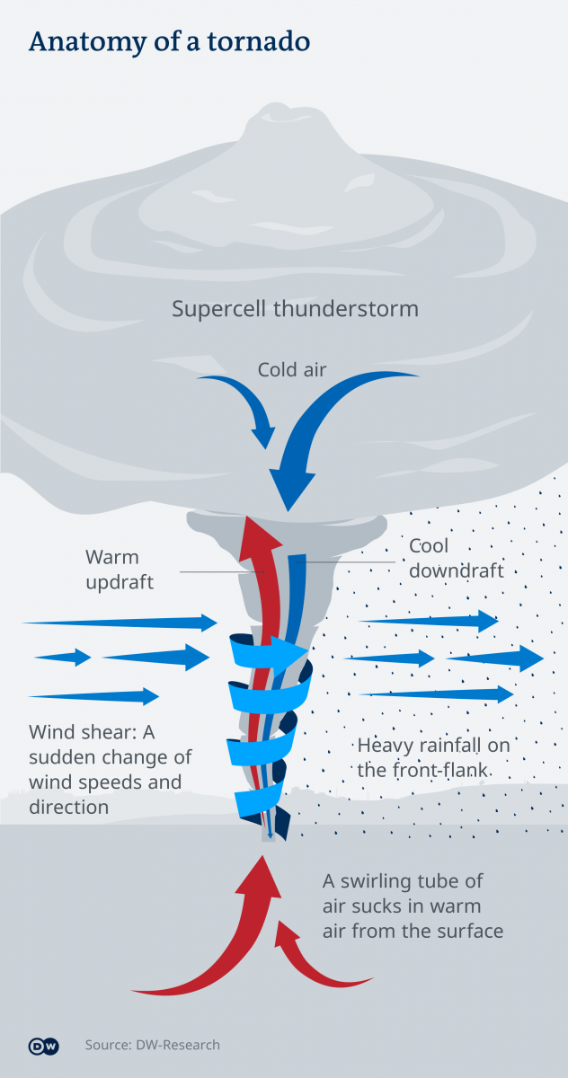
Huge amounts of convective energy can build up east of the Rockies when warm moist air from the Gulf of Mexico surges north and is heated by sunshine. When drier air surges aloft, it can act as a lid on this warm moist air rising as the land heats, with thermals reaching a certain height but not rising any further to cool and condense into clouds. This lid can concentrate this energy, creating large amounts of CAPE (Convectively Available Potential Energy) of up to 4,000 to 5,000 j/kg in summer. In the UK will rarely reach more than 1,500 j/kg. This pooling of CAPE leads to what is known as a ‘loaded-gun’ situation, where a forcing mechanism, such as a front, trough or convergence, is required to force the warm moist air up through the lid or cap. This can lead to explosive amounts of energy being released and can lead to large damaging hailstones and destructive tornadoes as updrafts exceeding 100mph are sucked up into storms. These strong updrafts keep hail suspended allowing them to grow larger and larger as the hail gets coated by frozen water droplets high in the frozen reaches of the cloud. Meanwhile, these very strong updrafts may start to rotate and increase in speed even more to form tornadoes - if strong low-level vertical shear is in place
Loading recent activity...