Another mixed day with hefty, thundery showers marching in from the west. Other areas missing them with mild air and spring sunshine. Temperatures are just dipping away now. Coastal flooding alerts.
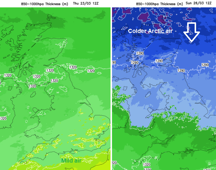
It remains very unsettled in a duller, wetter-than-average March so far, as a series of Atlantic systems continue to move from West to East across the country. These will bring further spells of rain or showers over the next few days. Although it is very mild at present, colder Arctic air is lurking just to the North of Scotland and will move southwards through the coming weekend, bringing a drop in temperature to all parts by Sunday.
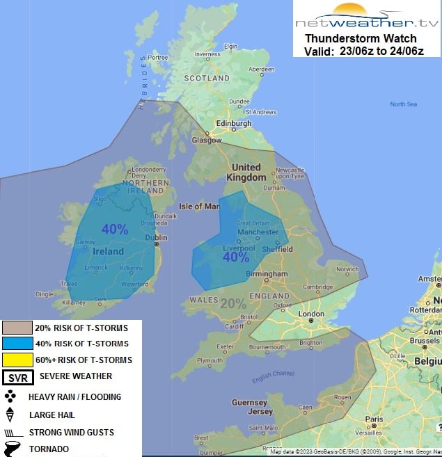
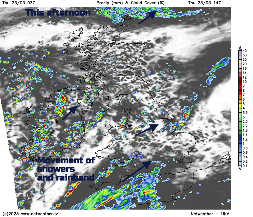
Most central and eastern parts are beginning fine and sunny, but there's already an area of showers across North West England and North Wales. Some are heavy, giving local thunder. Convective forecast "Thunderstorms possible across Ireland, Wales & N England today, with risk of hail and gusty winds. More isolated t-storm risk elsewhere."
Through the day further blustery showers will develop across England and Wales. Again some will be heavy locally, some areas seeing more than others, with parts of eastern England and eastern Scotland having the best chance of missing them altogether. However, across Northern Ireland, in the West and the South, they'll become widespread. Here the showers start mostly towards the coast but then merge into a longer spell of rain that'll move into the Home Counties, Essex and later Suffolk through the afternoon.
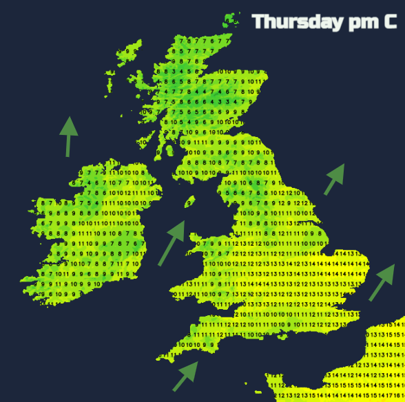
The blustery South to South Westerly wind will be fresh or strong across England and Wales. There will be gusts in the West up to 50 or 55 mph over exposed coasts and hills and in the squallier showers. But it'll stay very mild, with temperatures reaching 8 or 9C in the far North, 11 to 14C quite widely, and perhaps 15C again in some sheltered eastern areas. Coningsby in Lincolnshire and Northolt (western Gt. London) reached 15.8C yesterday. Cardiff 15.5C and the top UK temperature was 15.9C in Weybourne in north Norfolk.
The wet weather in the South and South East could spread as far North as Norfolk, to The Wash and the East and South Midlands into the evening, before clearing away into the North Sea overnight. Elsewhere expect further showers which will be most frequent in the West where some, especially across Northern Ireland, continue to be heavy and lengthy, perhaps with thunder. There could be a spell of heavier rain and strong, gusty winds for the Channel Islands this evening and Kent before midnight. There are still higher tides and numerous coastal flood warnings and alerts.
"Coastal/tidal flooding is probable along parts of South West England coasts on Thursday and Friday, with more widespread flooding possible for North West and South England coasts from (Wednesday) until Friday." Env Agency
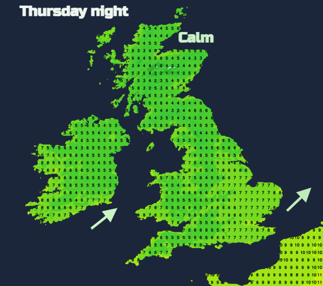
East of the Pennines, a brief lull will allow clear spells to develop, with further showers here more likely later in the night. That blustery South West wind will freshen again and temperatures dip slightly, 4 to 6C across the North and 7 to 10C further South.
Friday is set to be another day of showers in a fresh or strong and blustery South to South West wind. There will be gales in the West, perhaps briefly severe over Northern Ireland where damaging gusts are possible. There'll be sunny intervals, mostly in the East, but the showers look more widespread than yesterday. Some will be heavy and lengthy, especially in the West, transferring eastward through the day. As a result, top temperatures of 6 to 9C in the North and 11 to 13 locally 14C further South will be slightly down on recent values.
Further showers are likely into Friday evening and overnight, but with clear intervals. As the wind turns to the West or North West it'll begin to feel colder especially over Scotland, although temperatures generally shouldn't fall below 4 to 6C in the North and 7 to 10C further South. The fall in temperatures continues during the weekend as a northerly wind takes hold.
Colder in the northerly wind this weekend.