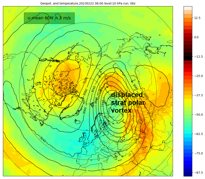
A major Sudden Stratospheric Warming (SSW) is now underway, with the stratospheric polar vortex already displaced from the pole over northern Russia, following zonal (westerly) winds at 10 hPa (high up in the stratosphere) reversing to easterly at 60 degrees North on the 17th February, pushing a weakened polar vortex away from its normal home over the pole.

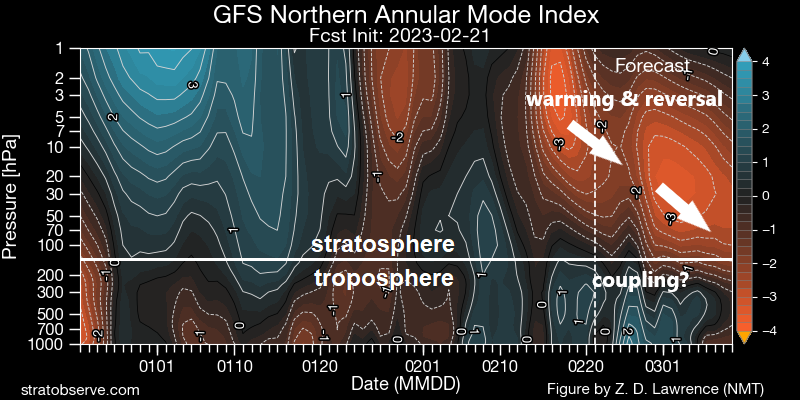
There are actually two stratospheric warmings since mid-month. The first one weakened the polar vortex and pushed it away from the pole, with a technical SSW of a reversal of zonal winds at 10 hPa 60N on the 17th. There will be a slight recovery of zonal winds at 10 hPa over the next few days, with the wind weakly zonal /westerly above 0 m/s, but it will turn easterly again (below 0 m/s) by early next week (27th) and staying reversed with stronger easterlies than from the first reversal. So the second warming looks to have a stronger impact with the reversal looking to propagate down to the troposphere where our weather happens.
The implications for our weather of the SSW and resultant polar vortex displacement to our northeast will still not be fully known for a few days. But there is growing signal from GFS and ECWMF weather model ensemble guidance for the displaced stratospheric polar vortex and stratospheric high over polar regions to be mirrored by upper and surface flow patterns in the troposphere (where our weather happens). This is thanks to the stratosphere wind patterns eventually coupling with the troposphere wind patterns.

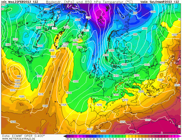
This mirroring of troposphere wind patterns with the stratosphere is showing up in recent weather model runs – which are signalling lowering heights / pressure and increasing deep cold pooling to the northeast of the UK over Scandinavia and NW Russia in the first 5 days of March and rising heights / pressure of the mid-north Atlantic north towards Greenland. Such a pattern, as shown by the 12z day 10 EMWF deterministic run chart below, could eventually pull deep cold air south across the UK in early March.

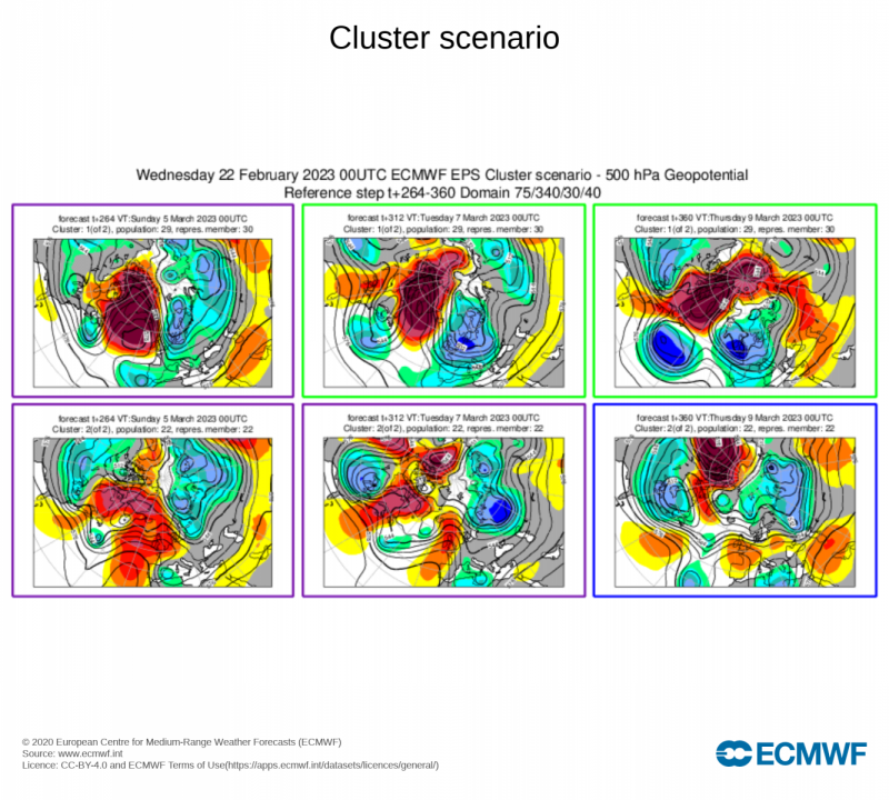
Weather forecasters tend not to rely on individual deterministic / operational runs for what may lie ahead more than a week away, rather they use ensembles. GFS runs 31 ensembles members, each with slightly tweaked starting data compared to the operational / deterministic run. This gives an increased range of possible states of the atmosphere in the future. ECWMF uses clustering of ensembles which display similar outcomes to each other, the cluster with the largest number of members showing a similar outcome, the greater the chance that outcome may come off. Below are the 00z EPS clusters for days 11-15, the largest cluster (29 members out of 51) shows a ridge to the west and trough to the east - with a northerly flow for a time.

However, with time, clusters also suggest low pressure moving out of North America over the N Atlantic towards Europe, which limit any deep cold flow reaching the UK from the north, due to the high near Greenland retrogressing too far west towards Northern Canada.
Today's NOAA CPC 8-14 day H500 prognosis also reflects current EPS and GEFS means in the same period, with Greenland/Iceland upper ridge and the troughing close to our east and northeast pulling down a cold arctic flow, but also the potential for lowering heights extending out over the North Atlantic from N America – which may eventually cut off the northerly flow should it phase with troughing to the east and northeast.
.gif)
But it must be stressed, these are ensemble means, so they mask a range of possible future outcomes which are uncertain given the models may not have a confident handling on the stratosphere -troposphere circulation coupling following the 2nd warming which looks evident on the GFS NAM index below.
A deep cold northerly flow, with potential to bring signiificantly low temperatures and even snow, is certainly a possibility in early March. However, lows moving east over the North Atlantic phasing with low pressure to the east and northeast of Britain may eventually cut-off the northerly flow. But still some uncertainty over whether the very cold air from the north will arrive, but if it does arrive, even more uncertainty over longevity. Lots of unknowns, but be prepared for a cold start to March, possibly very cold with a risk of snow for some. However, we’ll update on this potential over the coming days.
Loading recent activity...