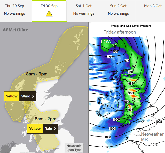
A deepening Atlantic low will bring gales to parts of Scotland and wet, blustery weather across the UK. It's a one-day event but will be quite a change.
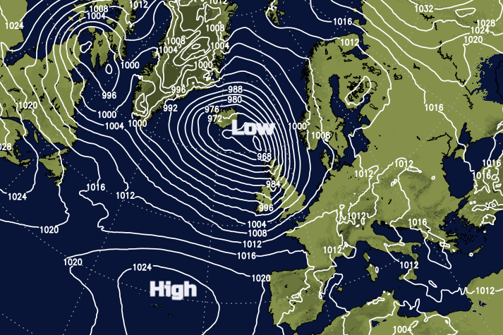
The UK will see wet and windy weather by Friday as a low pressure deepens between Iceland and northern Scotland. The band of rain will move steadily southeastwards through the day with the strongest winds for the Scottish Islands and Highland region, up to severe gale force at times.
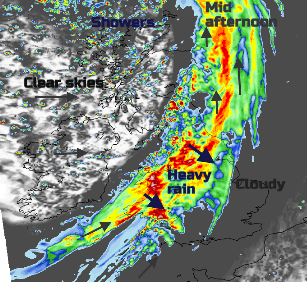
The frontal rain bands will sweep across the UK during Friday. This will bring a spell of heavy rain to all parts. Heavy rain is forecast over the Western Isles before dawn and will then soak western Scotland and Northern Ireland on Friday morning. By lunchtime, it will reach more of Scotland, northern England and western Wales with heavy downpours for NW England, the Pennines and Snowdonia. Through Friday afternoon the heavy rain will spread over more of Wales and England, reaching East Anglia, London and the southeast by evening. Conditions on the roads are expected to be difficult for the Friday evening rush with poor visibility, surface water and spray as the daylight fades.
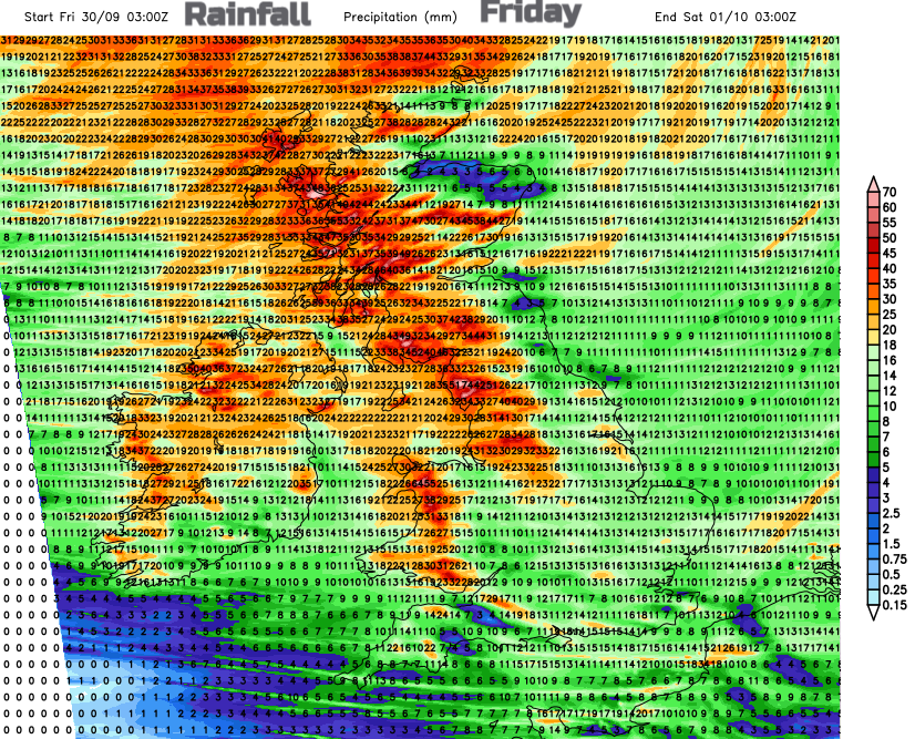
The 24-hour UKV rainfall chart shows the heaviest rainfall over Northern Ireland, Wales and Scotland although with some eastern shelter for both. Also, high rainfall totals for NW England into the Pennines and particularly for Cumbria.
Env. Agency for England forecast 29th Sept – “Local flooding is possible from rivers and surface water across parts of the West Midlands and parts of the north of England on Friday. Land, roads and some properties may flood and there may be travel disruption.”
"Minor flooding impacts are likely across some parts of Scotland during Friday which may lead to some disruption."SEPA
Many areas are still crying out for rain after many dry months. Western areas will see heavy rain in a relatively short time which could lead to localised flooding in prone spots or large puddles. 20 to 50mm of rain is likely which is 1 or 2” in just a few hours.
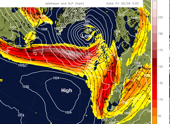
A stronger jet will be powering straight across the north Atlantic and it is the left exit area of that jet core which will develop Friday’s low. There will be further deepening early on Friday but there are only slight differences in timings from the various models around the rainband progress down through Britain.
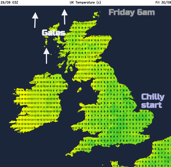
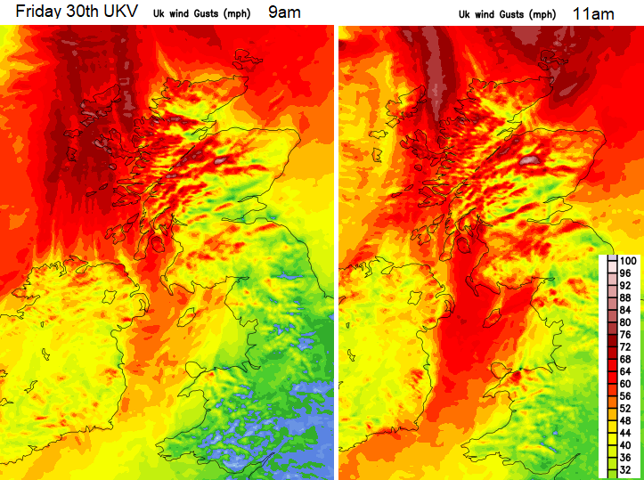
Friday will start off chilly for parts of Britain. Much of England and Wales will have light winds, clear skies but with mist and fog forming due to the low temperatures first thing. It will be quite a change by the end of the day. The Western Isles will experience southerly gales through the night as the rain sets in and then severe gales with gusts over 70mph to start Friday. The Minch inshore waters mentions “perhaps increasing Storm Force 10”.
There are already warnings that ferry services for west coast Scotland could see disruptions and it will be a wet and windy start here and also for Northern Ireland. Care will be needed around exposed coasts and over high ground as the wind speeds increase and high gusts continue. Gradually as the heavy frontal rain passes the southerly winds will veer to a westerly.
Around lunchtime the Northern Isles will see gales from the south, even severe gales with gusts over 70mph. It will be very windy through the Irish Sea, again with possible impacts on Ferry services and very wet and windy for the Solway Firth, Isle of Man, Cumbria, Dumfries and Galloway and Gwynedd around lunchtime. The winds will be strong SSW reaching gale force for exposed coasts and hills. Aberdeen will be windy in the afternoon as the front clears. This leaves brighter skies for much of Scotland and Northern Ireland in the afternoon but with a rash of sharp showers whizzing in on the brisk westerly wind.
The weather deteriorates across more of England and Wales through the afternoon with a moderate to fresh SW wind. There will be gusts of 50 to 60mph for exposed coasts and hills with a clearance from Kent by midnight.
This is not a hugely disruptive weather event, not a named storm but certainly looking wild in the far NW to start Friday. And yet it will be the beginning of a progression, no doubt, of autumn lows and seasonal wet and windy weather. People could have travel plans on Friday, particularly for Friday evening, so the warnings are a heads up that there might be impacts from this wet and windy spell. However, it is moving through with steady progress NW to SE before the weekend. It’s not related to Hurricane Ian, which stays over continental USA.