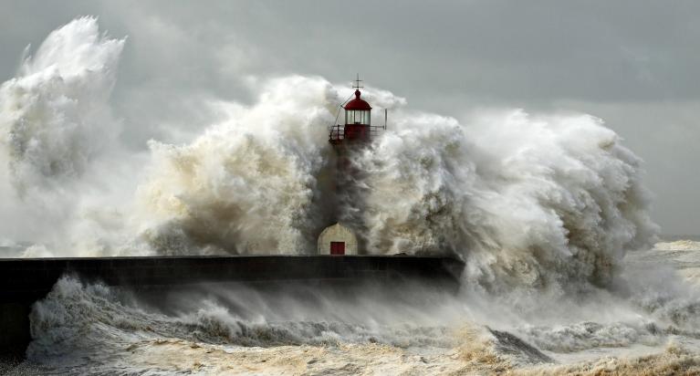
Hurricane Ian makes landfall on the west coast of Florida as a category 4 storm, with 155mph sustained winds and catastrophic storm surge bringing extensive flooding and destruction to properties in densely populated low-lying communities near the Gulf coast.
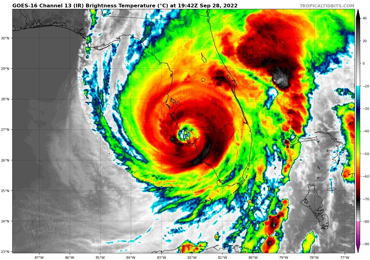
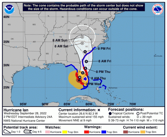
Hurricane Ian has made landfall along the west coast of Florida as I type, the eyewall moving ashore over Fort Myers on Florida’s Gulf coast, mid-afternoon local time. Ian strengthened into a category 4 hurricane earlier today and maintained this intensity all the way through to making landfall, packing sustained winds of 155 mph, with gusts of up to 175mph. Sustained winds just shy of making it a category 5 hurricane. Though Ian is only moving at around 9 mph before landfall.
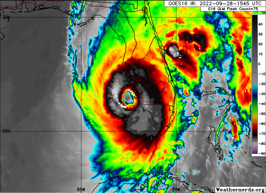
Such destructive winds in the eastern eyewall have already been battering the barrier islands to the west of Fort Myers on the southwest Florida coast. Sanibel Island looks particularly badly impacted by the storm surge. But now video footage is coming in of streets underwater in Fort Myers, with buildings being washed away and destroyed as the hurricane makes landfall here. More than 800,000 people are without power across western Florida as destructive winds and flooding reek havoc.
The National Hurricane Center had warned of “life-threatening storm surge, catastrophic winds and flooding in the Florida Peninsula," with millions under evacuation orders. And, unfortunately, footage now coming in shows these worst fears are being realised as Ian makes landfall.
The storm surge created by Hurricane Ian could be the most catastrophic of impacts, but extreme heavy rains and damaging winds unleashed by Ian will also add to the woes of those in the direct path of Ian towards the coast of the southwest Florida Peninsula, where there are exapnsive low-lying densely-populated communities.
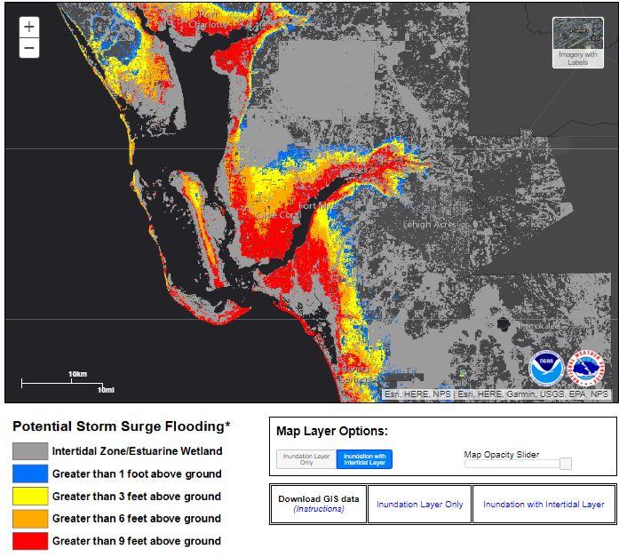
Naples on Florida’s southwestern Gulf coast, just south of Fort Myers, saw storm surge water levels rising fast this afternoon ahead of Ian. There was around 1 foot rise in 10 minutes, rising to a record storm surge levels, thanks to strong winds on Ian’s southeast flank blowing onshore as it approaches the coast. Further north, in Tampa Bay to the north of Ian’s landfall, water levels are actually receding as I type, because the wind direction is offshore. But water levels here at risk of rising rapidly as the wind changes direction.
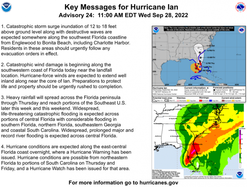
Up to 18 feet of dangerous storm surge is forecast along Florida’s Southwest coast, including Englewood, Bonita Beach and Charlotte Harbor. So, the biggest concern with Ian is the storm surge and even though Ian has made landfall, the storm surge is far from over.
Hurricane Ian is expected to make two landfalls, today along the west coast of Florida, then again along the Atlantic coast of southeast USA on Friday. So areas of coastal Georgia and South Carolina will probably be advised to make preparations, with possibility of Ian re-intensifying over the warm Gulf Stream waters of the Atlantic off SE U.S.A.
The track of Hurricane Ian is eerily similar to Hurricane Charley, which also crossed western Cuba then made landfall along Florida’s west coast at category 4 intensity on August 13, 2004. However, Ian is much larger than Charley was, with Ian’s area of hurricane-force winds 2.9 times larger than Charley.
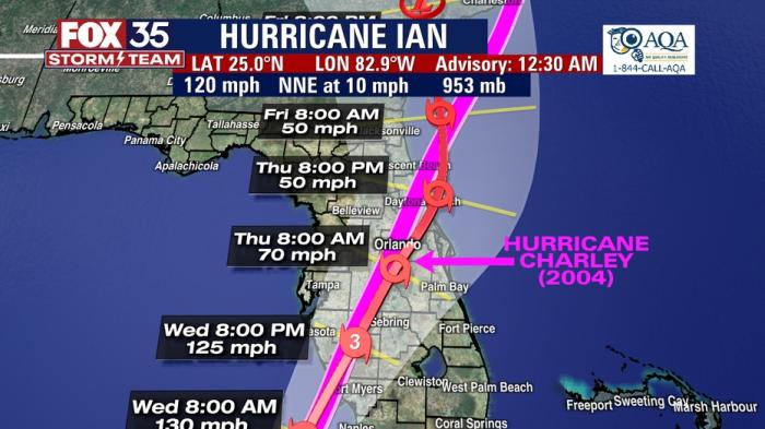
Charley took a similar path to that forecast for Ian, a path that tore across the Peninsula with damaging winds before sweeping into South Carolina after a second final landfall.
Charley caused $24.6 billion damage (adjusted to 2022 dollars). At the time it was the nation's second costliest hurricane behind only Andrew.
The larger wind field of Ian means the storm surge will be higher than was the case for Charley across the southwest Florida coast near and to the south and east of the Ian’s landfall.
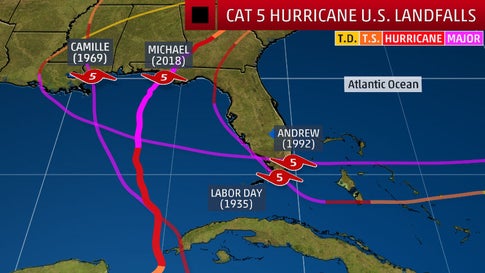
And to put into context what an exceptionally dangerous Hurricane Ian is being close to cat. 5 hurricane at landfall, only four category five hurricanes have ever made landfall in the continental U.S. with winds over 157 mph: Labor Day in 1935 with 185 mph winds; Camille in 1969 with 175 mph winds; Andrew in 1992 with 165 mph; and Michael in 2018 with 160 mph. Nearly all of these occurred during a two-week period that runs from August 17 to September 2. The names of the hurricanes are the most notorious in weather history so are not repeated again in the lists of names created each year.
Although Hurricane Ian made landfall as still very powerful cat. 4 hurricane, it could still make history for one of the most devastating hurricanes to hit Florida, especially the southwest of the Peninsula, given the scale of storm surge flooding and resultant destruction being witnessed as I type.
Loading recent activity...