Weekend weather: A deep low on Friday will throw heavy rain across the UK with strong winds. Uncertainty about rain in the south on Saturday but blustery showers rush in from the Atlantic then fade on Sunday.
A deep area of low pressure is heading across the north Atlantic to end the working week. This will bring heavy rain on Friday with strong winds and gales for exposed areas then leave a windy, showery flow for Saturday. There will be plenty of showers for exposed western counties, fewer further east and gradually cooler air. Forecast confidence then decreases around more rain for southern Britain. Will a frontal wave return and bring rain to southern England, or a cluster of heavier showers push in from southwest England and work across to London by evening? It looks like pressure will rise on Sunday and slowly subdue the showers and brisk winds. This leaves the weather on Sunday looking more settled.
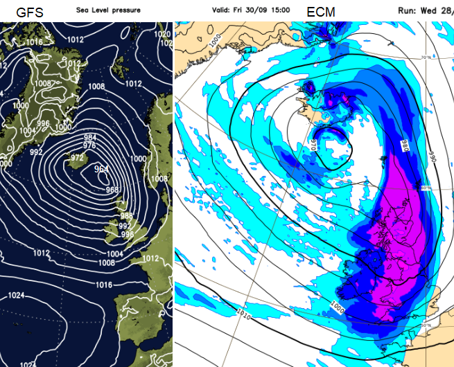
This low pressure will spend the next few days moving towards Iceland, interacting with the jet stream and deepening. Current timings show the intense frontal rain sweeping across Northern Ireland and western Scotland during the middle of Friday and then soaking the rest of Britain during Friday afternoon and evening. It could be that the rain doesn’t arrive over SE England until later on Friday evening but keep an eye on the Netweather Radar to see how far away it is. It will be windy everywhere with a southwest wind veering to a westerly later.
There could be disruption to travel with plenty of surface water and spray, speed restrictions on motorways and poor visibility.
There will be heavy rain overnight for southern Britain and East Anglia, so take note if you are camping this weekend. Skies clear behind the front but there will be showers packing in from the west. These showers will be heavy at times with occasional lightning, even hail or sleet over the mountains. The tops of the Scottish mountains have already seen a dusting of snow this week.
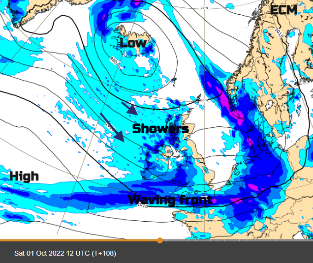
The ECM model shows the frontal band waving up over southern England, maybe into south Wales during Saturday bringing another spell of very wet weather. All the time the north-westerly flow will bring more blustery showers with a few bright spells but eastern Britain could be more sheltered and see some sunshine.
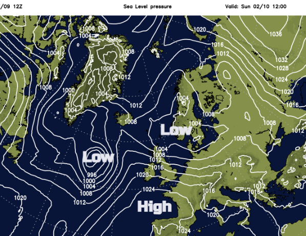
That frontal band in the south clears from Kent overnight and leaves the more settled weather for Sunday. However, the showers take their time to fade from NW Britain and northern Scotland.
The GFS model does not develop the southern wave on Saturday and so shows drier weather although with blustery showers passing by from the west. And the same high pressure builds to the south which allows a settled Sunday for many parts. The far north of Britain keeps the risk of a few showers though.
The Netweather MR model picks out a cluster of heavy showers or even a small circulation with strong winds moving across SW Britain then southern England on Saturday. This reaches SE England by Saturday evening with strong winds through the English Channel during the day. It leaves a blustery flow from the west on Sunday but does look drier for most parts of the UK. Gwynedd, Co. Londonderry, Lancashire and Highland all keep the risk of showers.
The UKMO model subdues the showers much more for Sunday. There will be more cloud over Northern Ireland, much of Scotland and NW England but overall, a fair day with brighter, even sunny skies for SE Britain.
Temperatures on Saturday will be 13 to 20C but windy, with the highest temperatures for the West Country, if there is fine weather rather than showers. It will feel cooler overnight especially for inland Britain where skies clear, down to 5 to 8C. Sunday should see the winds easing and similar temperatures but the highest over SE Britain.
There will be a bout of strong westerly winds during Saturday night and Sunday morning passing from Argyll over Scotland and affecting northern England. The heavy showers will still be around for the west coast but early hill walkers do be aware that the strong winds will take their time to ease down. Eastern England remains blustery into the afternoon even if there is more sunshine.