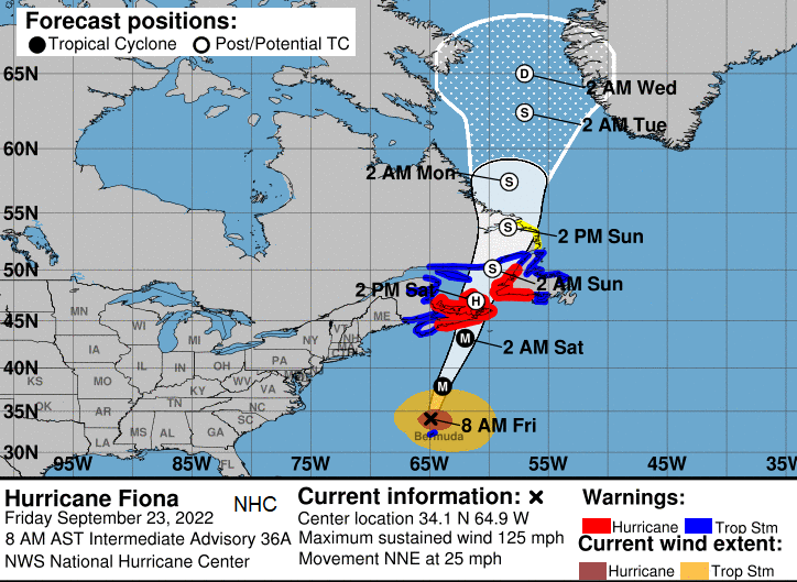
“Hurricane Fiona has the potential to be a landmark weather event in Eastern Canada this weekend, and we encourage the public to continue to monitor the forecasts regularly. “ CHC Sept 2022
Most of the hurricane watches and warnings in the Atlantic come from the NHC, the National Hurricane Centre, which is part of the National Weather Service of the United States. If a tropical cyclone moves out of the NHC area, which can happen as Hurricanes or Tropical Storms move far north and east in the Atlantic and leave their tropical state, warnings pass to the remit of other national weather services. Such as the UK Met Office, Met Eireann or AEMET and IPMA for the Iberian Peninsula. When Hurricanes just keep heading north from the Caribbean, they can affect eastern Canada. Sometimes they manage to reach the Maritime provinces (New Brunswick, Nova Scotia, and Prince Edward Island) or hit Newfoundland & Labrador as a hurricane or tropical storm. They can change to a post-tropical cyclone, that has transitioned from its warm core and tropical status, or they just cling on as a hurricane over increasingly colder waters. Sometimes it takes months of analysis to tell what happened, and when, but either way there can be huge amounts of rainfall, high winds and serious disruption.
"Canada has a hurricane centre because tropical storms, hurricanes and post-tropical storms can have a significant impact on Canadian weather and on Canadians."
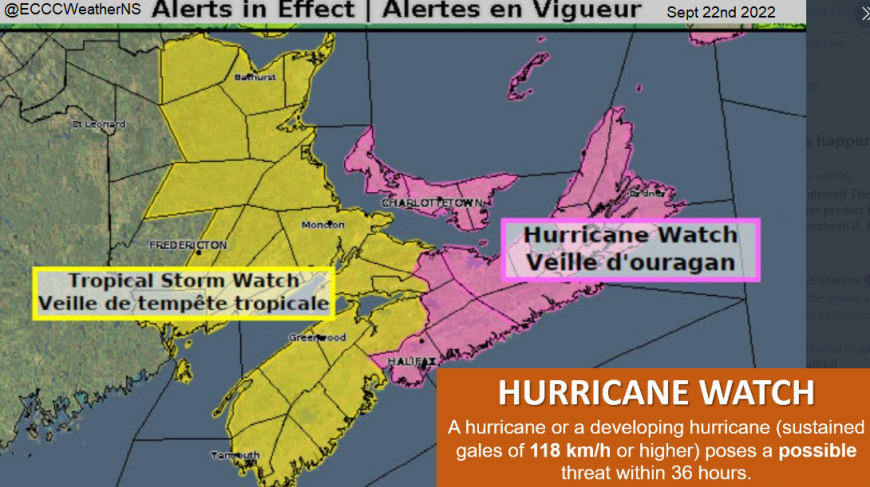
Example warnings and watches from CHC
Environment and Climate Change Canada’s (ECCC) Meteorological Service of Canada (MSC) is the agency responsible for delivering Canada’s weather service. The Canadian Hurricane Centre (CHC) becomes operational “when a storm system of tropical origin enters or threatens to enter the designated response zone (north of 36ºN and west of 41ºW) within 3 days”. However, the CHC can issue bulletins up to five days before to help with consistent and informed messaging about the storm and its impacts.
Autumn in this part of the world can bring significant storms, deep extratropical low pressures from the interior with howling winds and heavy rain, even snow later in the season. People here know about stormy weather. The issue with warnings for maritime tropical cyclones is that although there is huge impact potential, there will also be uncertainty about the track. This accompanies the geography of the region with areas of water in between large islands and the open Atlantic. There is plenty of space for a storm not hit land, which can result in perceived ‘it wasn’t that bad’ when in reality, highly dangerous conditions were just a mile offshore.
The main issue is convincing people to act this time. For remote, large areas, people have to protect themselves, using reliable and timely information.
Clear, concise and familiar messaging is needed alongside ongoing education. If you live in Canada and are used to the format of Environment Canada’s warnings and maps, then it makes sense to get Tropical Cyclone information in the same place.
Challenges around hurricane preparation and public engagement include recovering from any false alarms. Unfortunately, these can be detrimental. A previous recent cyclone can lead to" it won't happen here again" beliefs when actually another cyclone can follow on quickly after one impactful event. These hurricanes are rare and so people are generally ill-prepared. There might be no recent memories of such events.
To try to tackle this there are various public awareness outreach programs through schools, government, the media and communities within Canada. With climate change, there must also be adaptation of vulnerable areas and increased resilience when looking at land management to deal with any increase in severe weather events.
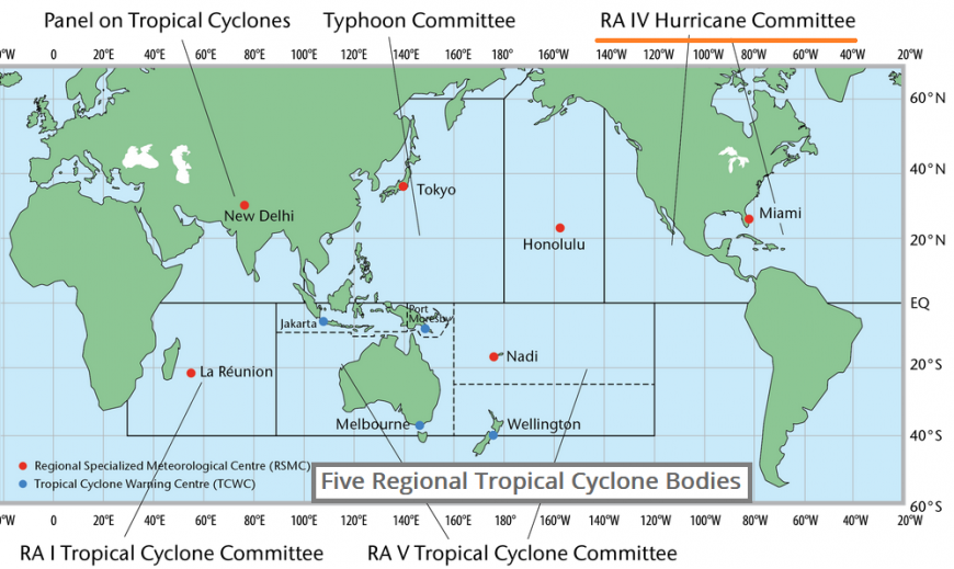
The national CHC was set up in 2000 after two regional centres were started in the late 80s. These had followed confusion around Hurricane Gloria in September 1985 when Canadians had to rely largely on U.S. forecasts for an intense storm. In the end, the storm's effects on Canada were much less than predicted and after a large study in 1986, Canada set up its own centre and joined the WMO’s Regional Association IV - Hurricane Committee, part of the TCP. "The TCP (Tropical Cyclone Programme) is tasked to establish national and regional coordinated systems to ensure that the loss of life and damage caused by tropical cyclones are reduced to a minimum."
The first CHC bulletin was for Hurricane Emily was in 1987 and used the same format as bulletins for the NHC. Tropical Storm Hugo hit Ontario in 1989 and many bulletins, warnings and reports followed from the Centre in the coming years with reconnaissance flights also starting up.
Like any national or tropical weather service, there were ups and downs but with overall progress toward quality forecasts and important life-saving warnings.
The backdrop of locals being familiar with regular severe autumn/winter storms did prove to be a hindrance when trying to warn of these different cyclones. It was hard to get across the varying wind strengths around a tropical core, depending on which quadrant passed by and the impacts of tropical rains. In 2003, Hurricane Juan's well forecast arrival found people unprepared. It had been more than 100 years since the city of Halifax has experienced such a hurricane (Cat2). Nine days earlier there had been an over-reaction of the media to Tropical Storm Isabel which then dampened their response to the real threat of Juan.
Some people did remember lesser Hurricane Hortense from 1996 but that had brought minimal impacts with landfall to the east of Halifax. Juan was just west of the city and much stronger. Some didn’t believe a hurricane would reach Nova Scotia and that the cold sea waters would weaken the storm. As is the case in 2022 for Hurricane Fiona, Sea Surface Temperatures (SSTs) were several degrees higher in 2003 than usual. The hurricane just kept on coming. Others believed that just as ‘lightning doesn’t strike twice’ another hurricane would not arrive. As is often the case, people and media focused on the track line diagram rather than the confidence and accompanying words and guidance.
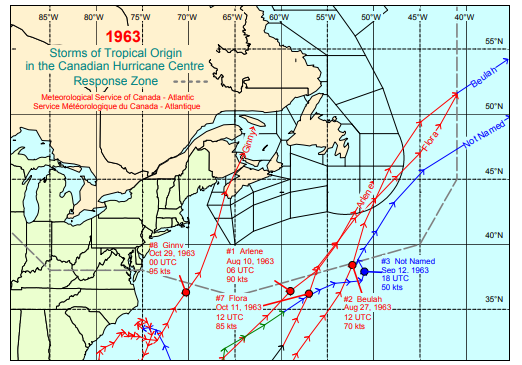
Juan 2003 and Ginny 1963 are seen as two of the strongest storms to affect eastern Canada but there have been others that have followed a path similar to that forecast for Hurricane Fiona 2022
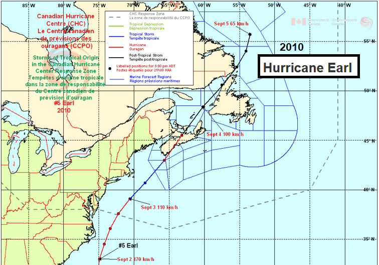
2010 EARL
What is striking about Hurricane Earl is how similar its path is to the forecast track of 2022 Fiona. Earl reached Cat4 in late August 2010, brushed North Carolina and made landfall in Nova Scotia on September 4th as a Cat1 hurricane with a central pressure around low 960mb. It moved across central Nova Scotia with hurricane force gusts, into the Gulf of St Lawrence and across Prince Edward Islands as a Tropical storm. It then transitioned and slowed down significantly as it approached SE Labrador.
Urban areas including Halifax observed peak winds of near 110 km/h (67mph) with driving rain. Trees snapped or were uprooted and roofs were damaged. Other tree branches fell and resulted in widespread power failures. It took several days for power to be restored in places. Reminders of these impacts are included in education and preparation resources. New Brunswick saw 3” of rain and there were wild conditions along the coasts. Peak waves of 23m (75ft) were recorded at the Halifax Harbour buoy. With a large tidal range in the area, how a cyclone coincides with the spring/neap or high/low tides is very important. Earl arrived at low tide but sea spray was blown inland by the storm’s winds which caused salt burn to foliage and vegetation.
“There was a period of approximately 10 hours prior to the landfall when the NHC was classifying Earl as a Tropical Storm, while the CHC was referring to it as a Hurricane (9 km/h /5.6mph difference between the two categories), an unintended discrepancy that generated some public confusion. Since the overall motion of the storm was accelerating, this small increase in wind at landfall is reconcilable, although 9 km/h of maximum sustained wind speed estimate is certainly within observational uncertainty. Discussions after the season resulted in Earl being officially classified as a Hurricane at landfall, but a strong Tropical Storm in the hours leading up to landfall. “ CHC
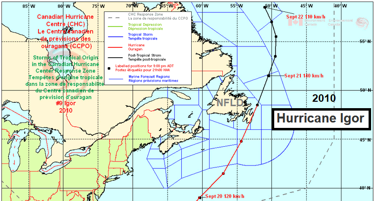
2010 IGOR
In the same month Hurricane Igor tracked west of Bermuda and then hit Newfoundland as a Cat1 hurricane. The central pressure fell to near 950mn as it hit eastern Newfoundland’s Avalon peninsula. It was Igor’s rain that caused the most impacts with well over 8” (200mm) for coasts in the south and east and 4” more widely. There were sustained hurricane force winds with gusts of over 100mph and a storm surge up to 1 metre high. Principal roads were washed away and communities were cut off. The recovery took a long time as new bridges were needed and rivers changed course. The military had to be brought in to help the relief efforts and deliver fuel and food. Igor was devastating for this most eastern part of Canada.
2011 Hurricane Irene had the greatest impact on Canadian forecast territory, bringing gusty winds and heavy rainfall and creating numerous problems in Quebec. Rivers flooded and many roads and bridges were damaged. Strong winds broke tree branches, causing interruptions to electrical service.
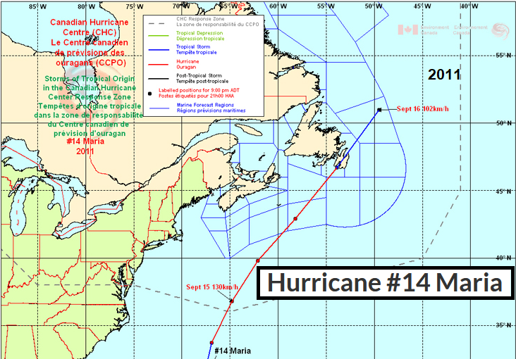
2011 Hurricane Maria made landfall in Newfoundland on Sept 16th as a strong Tropical Storm, down to 985mb. It transitioned to a post-tropical storm whilst leaving Newfoundland and merged with another low. This combined low pressure affected northern NFLD and Labrador on the 17th.
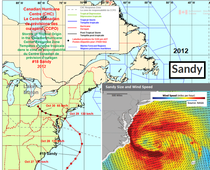
Hurricane Sandy- this was a very high-profile event for eastern seaboard and with major disruption for NYC. Its arrival on the evening of October 29 over New Jersey coincided almost exactly with high tide on the Atlantic Ocean and in New York Harbour
Sandy became a very powerful post-Tropical storm just prior to landfall near Atlantic City, New Jersey during the evening of October 28th. Post-Tropical Storm Sandy weaken rapidly after landfall and tracked west-northwestward into Pennsylvania on October 30th then dissipated on the 31st. However, it managed to cause extensive damage as the circulation extended well into eastern Canada and the Great Lakes. High winds blowing down the length of Lake Huron resulted in high waves and a storm surge, with seas of five to seven metres measured at the southern end of the lake disrupting transportation. There was tree damage in southern Ontario leading to power outages and other wind damage to vehicles, businesses and houses within areas warned by CHC.
There were difficulties with communication for Sandy affecting Canada as the devastating impacts in New York City and New Jersey had already been seen on television from this monster storm. This challenge was similar to the issues in the mid-80s with Hurricane Gloria that led to the setting up of the CHC. The early threat of heavy rainfall and flooding was adapted as the forecast changed and the concerns about wind impacts was increased for Ontario.
2014 Post Tropical Storm Arthur made landfall in SW Nova Scotia on July 5th 2014. It was a powerful storm with sustained winds of around 68mph and uncommonly early in the season. For such a strong tropical storm to reach the Maritimes in mid summer was most unusual and there was tree damage, power outages and localised flooding.
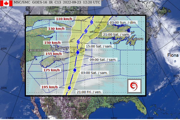
Fiona looks to be an astonishing event with very low pressure. It might break the national pressure record.and produce enormous waves.
Saturday 24th September sees a central pressure in the 930s mb forecast for Fiona. This could be the strongest hurricane or deepest low pressure to impact Canada on record. Hurricane Ginny in 1963 reached Nova Scotia at the end of October with a 948mb central pressure south of landfall and was one of the strongest cyclones for this region.
This will be an incredible, intense time for the CHC as Hurricane Fiona moves from the NHC area into their region and towards Canada.
As a storm progresses into the Canadian response zone, the CHC communicates with meteorologists at the NHC to discuss and update specific storm characteristics (i.e. exact position, predicted track, etc.). The information bulletins are produced by the CHC and shared. These warning bulletins are one part of the warning product package generated by the CHC. The second part of the package consists of live briefings given by CHC representatives. When a severe storm is approaching, the live briefing (by phone or online) will take place daily. Public Safety Canada and provincial emergency managers can attend remotely and then get on with their action plans.
"These storms often bring severe rainfall and wind speeds and behave differently than other types of storms and can therefore be quite complex and challenging to forecast. The Canadian Hurricane Centre provides the public with the expertise of specially-trained forecasters and issues tropical cyclone-specific public warnings to warn the public about these potential weather hazards. " CHC
More Fiona discussion in the Netweather community forum
Loading recent activity...