The Australian Bureau of Meteorology (BOM) confirmed on Tuesday that La Niña conditions have returned following recent cooling in the central tropical Pacific, with models indicating cooler than average ocean temps here will be sustained until at least the end of 2022.
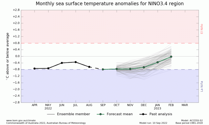
That current La Niña pattern started in September 2020 and it will be this century’s first “triple-dip“ La Niña, spanning three consecutive northern hemisphere winters and only the third since 1950. The most recent was late summer 1998 through to Spring 2001, before that, between 1973 and 1975.
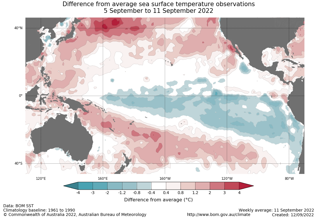
La Niña is part of the El Niño Southern Oscillation and is characterised by the development of cooler than average sea surface temperatures (SSTs) in the central and eastern Pacific Ocean. It is one of the main drivers of weather in the around the world, especially during late autumn, winter and early spring.
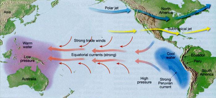
La Niña occurs when strong winds blow warm water on the surface of the Pacific Ocean near the coast of South America across the equator toward Indonesia, other parts of Asia and Australia. It's the opposite to the more well-known El Niño, which occurs when water in the central and eastern Pacific Ocean is warmer than average. Though this would be the first "triple dip" La Niña this century, it commonly occurs over two consecutive years.
La Niña causes cooler water to rise to the surface of the Pacific Ocean, which has wide-ranging ripple effects on the weather globally. La Niña has historically been associated with cooler global temperatures. But La Nina’s cooling effect on the planet did not stop 2021 from being one of the seven hottest years on record, while the summer of 2022 was the hottest on record for Europe and China, the second-hottest for North America and Asia, and the fifth-hottest June-to-August period globally since record-keeping began in 1880. This summer has seen the joint 3rd warmest August on record for the UK, with the average temperature being 0.3°C higher than the 1991-2020 average. And the sixth warmest July on record in the 143-year record. High temperature records broken around the globe, including the first time 40C has been exceeded in the UK.
Every month has been above average temperature-wise over the UK so far this year, while all the months up to August have seen below average rainfall apart from February. Generally, La Niña often tends to promote blocking high patterns over Europe and that has certainly been the case for large parts of this year, bringing below average rainfall and often well above average temperatures across the UK and also large parts of Europe too. The blocking has been particularly acute during summer this year, leading to prolonged drought and heatwaves.
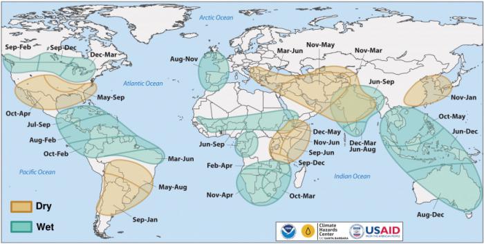
Timing of wet and dry conditions related to La Niña
On a more global scale, La Niña is thought to have contributed to flooding in eastern Australia this year and exacerbated droughts in the United States and East Africa. Ethiopia, Kenya, and Somalia are facing their worst drought in 40 years, with three years of La Nina likely exacerbating the serious drought in the Horn of Africa and creating a humanitarian crisis . Scientists say such a long La Niña period is probably just a random event, but some researchers predict that climate change could make La Niña-like conditions more likely in the future due to changes in ocean currents from fresh cold water from melting ice sheets in polar regions. The changes in ocean currents could be leading to a series of air pressure changes leading to a strengthening of tropical Pacific trade winds – which ultimately lead to cooling of the central and eastern Pacific and thus La Niña conditions.
An increase in La Niña conditions in the future would increase the chance of flooding in southeast Asia and Australia. A flood-weary eastern Australia have been told to expect more flooding in the coming months, as La Nina continues. While, elsewhere, continuing La Nina conditions may extend the risk of droughts and wildfires in the southwestern United States, and create a different pattern of hurricanes, cyclones and monsoons across the Pacific and Atlantic oceans, as well as give rise to other regional changes, such as pressure patterns over Europe.
La Niña typically suppresses hurricane activity in the central and eastern Pacific basins due to stronger vertical wind shear and enhances it in the Atlantic basin due to weaker vertical wind shear and trade winds.
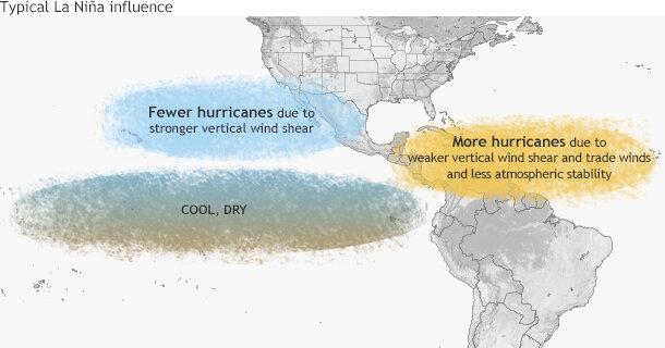
However, the Atlantic Hurricane Season has been quiet so far this year. Despite a recent flare-up of activity, with two-named hurricanes, Danielle & Earl, the 2022 season continues to lag and average season’s count of named storms by now. As of today, just six named storms have formed, two of which became hurricanes and as of last night Tropical Storm Fiona - which could become a hurricane next week. That's about four storms and two hurricanes behind the average pace, according to the National Hurricane Center. But La Niña has being ongoing since September 2020 and the 2021 Atlantic hurricane season was the third-most active Atlantic hurricane season on record.
Perhaps because a triple-dip La Niña is so rare, we may be seeing more unusual and exteme weather patterns and events which are not typical of a more normal La Niña patterns. But also these extreme events of prolonged flooding, drought and heat are being amplified by global warming. Which may make long-range forecasting this year more difficult, more particularly the winter season – which is normally easier to predict than other seasons of the year. Certainly weather patterns were unusually blocked over Europe, leading to extreme heatwaves, including the U.K. Perhaps we can expect more unusual weather pattens over the coming months?
Loading recent activity...