
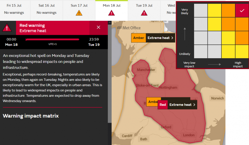
The UK Met Office has issued a red ‘Extreme Heat’ warning. It runs from Monday 18th July 2022 until Tuesday 19th. It comes as the signal of “Exceptional, perhaps record-breaking, temperatures” has strong agreement in the computer forecast models for early next week.
“An exceptional hot spell on Monday and Tuesday leading to widespread impacts on people and infrastructure.”
This intense heat will affect the UK by day and night, building from Sunday onwards. Scotland could reach the low 30s, Northern Ireland into the high 20sC and for Wales and England, widely into the 30sC.
This kind of warning only began last year, added to the suite of national weather warnings relating to the impacts severe weather could cause. These warnings are not just about the wind strength, the amount of rain, and temperature values, although those are important. It is about the background picture of recent ground and environmental conditions but also the capability of services to respond.
“Population-wide adverse health effects experienced, not limited to those most vulnerable to extreme heat, leading to serious illness or danger to life. Government advice is that 999 services should be used in emergencies only; seek advice from 111 if you need non-emergency health advice.”
Health providers are also now on red high alert in England “Reached when a heatwave is so severe and/or prolonged that its effects extend outside the health and social care system. At this level, illness and death may occur among the fit and healthy, and not just in high-risk groups.”
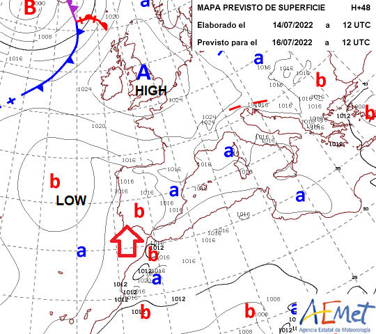
This heat already exists over NW Africa and Spain, Portugal. A cut off low will pump the very hot air northwards as our weekend high pressure glides to the east of the UK and helps pull the hot air towards the UK. Spain, Portugal and France already have heatwave warnings. With temperatures in the mid to high 30s and reaching 40C.
In 2003, it was estimated there were tens of thousands of premature deaths in the long summer heatwave across Europe. Elderly people are more vulnerable to the effects of extreme heat, just physically with age but for some, due to mental capacity. This can be the case for others of any age, are they able to understand what the warnings mean and how ongoing heat can affect the body and make informed decisions for early next week? Also, for those with ongoing health conditions, this episode will be an extra huge layer of strain for the body to cope with. For those not taking seriously how intense the heat will be, just Google ambulance waiting times as a baseline for your decision-making around heatstroke avoidance. What your body is used to is important, not that other countries see 40C. Decent air-con is still rare here in the UK.
Just taking it easy, seeking airy shade and rest, drinking more fluids is the main advice, if you can. For those who have to be out in the heat, just prepare for delays and maybe try to avoid the middle sections of the days. Covering up and leaving extra time to allow your body to adjust. Night time is going to be difficult.
The UK Extreme Heat red area covers large population centres with forecast temperatures widely of mid 30sC and charts showing high 30s, even low 40s C. Nights are also likely to be exceptionally warm, especially in towns and cities.
“Substantial changes in working practices and daily routines will be required”
The UK record is 38.7°C at Cambridge Botanic Garden on 25 July 2019. Before that, in 2003, the UK record was 38.5°C, at Faversham on 10 August 2003.
The colour of warning, yellow, amber and red is generated using a combination of 1. Likelihood- how confident are forecasters in the direction of the model story. 2. Impacts -how will this affect people, infrastructure and businesses. We have seen the High Impacts column being highlighted for a while now with the Amber warning for heat. It has taken until now to firm up the likelihood and confidence to move these areas to Red.
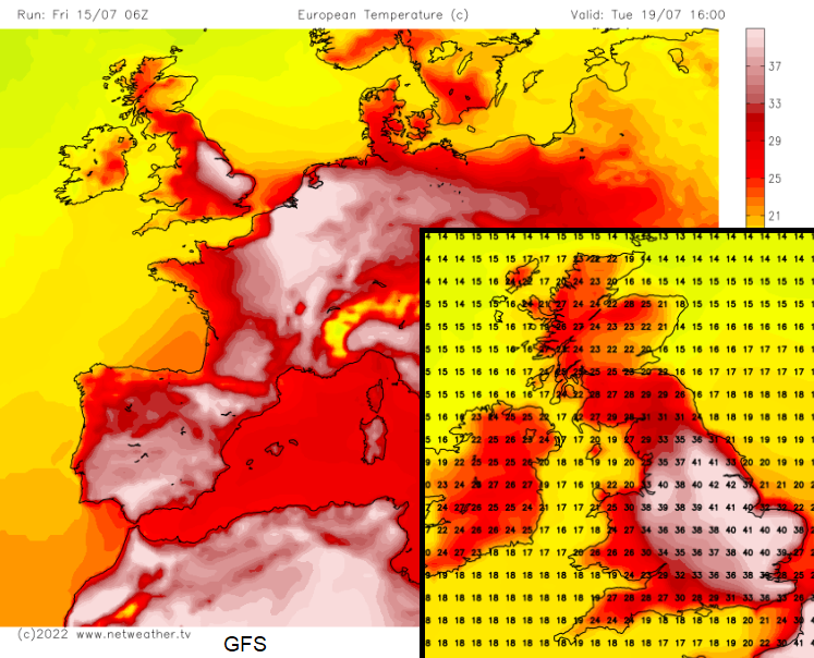
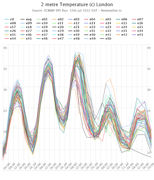 Ensemble forecast showing over 30C Monday Tuesday and some nearing 40C. The GFS model is even hotter.
We have already had some very warm days as strong sunshine heats the ground, day by day but as this hot air arrives on Sunday, we will have the strong July sunshine combined with unusually hot air reaching the UK. It will be the relentless nature of the heat, day and night, that will cause problems. The structure and fabric of cities holds the heat, stores it, and so the temperatures increase.
Equipment will overheat, which could affect power systems and other essential services. Water safety is being highlighted as people will try to cool down in lakes and rivers or at the coast. Disruption on roads, rail and to air travel looks likely with the heat not helping people's stress levels. Air pollution levels will also rise, in the hot continental air. This brings further health concerns with poor air quality. And look after your pets, dogs die on hot walks.
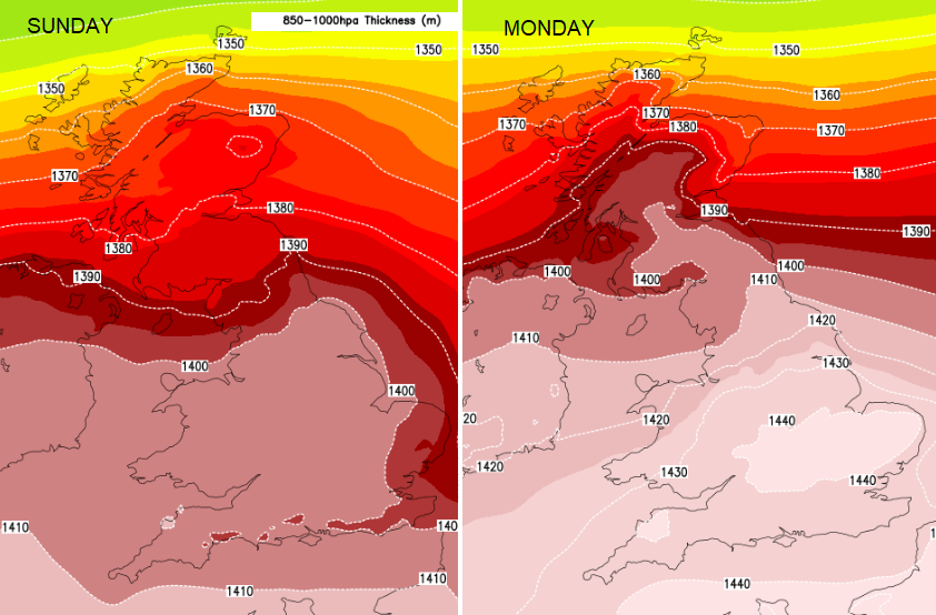
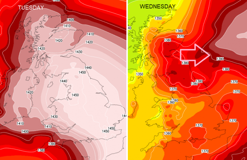 The arrival and departure of this anomalously hot air mass
There is a high chance that the UK record will be broken and a fair chance that 40C will be reached. It looks to end by midweek, so relatively short-lived, with showers appearing from the SW then NW later on Tuesday and overnight into Wednesday. As the last of the heat fades from eastern Britain on Wednesday there could be heavy, thundery showers but a lot of uncertainty.
Let’s get through this heatwave episode with the main advice being to start planning your own adjustments to cope with the heat early next week. And looking out for those who may need help. More summer weather discussion and chat on the Netweather community forum.
Loading recent activity...


