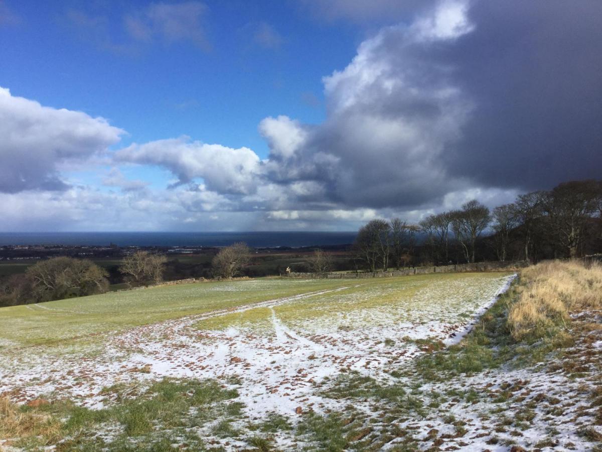
With many areas not seeing any snow falling, let alone settling snow this past winter, it’s perhaps ironic that snow has fallen in many places from widespread wintry showers on the last day of March and potentially the first day of April, particularly following a spell of warm weather – with temperatures reaching 20C last weekend in a few spots.
Predicting snow in the UK is often difficult, as the conditions are often marginal – where there is a fine line between snow falling or rain. This often the case in winter and even more so in late March or early April during the day– when the sun is stronger thus warms up surface temperatures quicker than in January. Often settling snow at this time of year, more particularly at lower levels, tends to occur when it’s dark and there is no influence from the sun. So, the freezing level at night, above which precipitation stays snow, tends to lower close to the ground. Snow can settle briefly during the day too this time of year, if the snow is heavy - as this lowers the ground temperature close to freezing, though this is more unusual away from high ground, any settling snow from overnight or daytime tends to quickly melt after snow stops falling.
Wintry showers falling as snow at times over the next 24 hours
.gif)
But there is a variety of factors, discussed below, which determines whether snow will fall or not, not just the temperature. It can still snow in late March and early April, even when the temperature is well above freezing, this happens when the surface airmass is dry, i.e. the dew point is 0C or below.
As a general rule of thumb, snow tends to fall when the air temperature is 2C or below. It doesn’t have to be 0C, because it takes a lot of energy to melt a snow flake, they can fall in air above freezing, though the flakes tend to be larger and wetter – sticking to surface more easily. Snow that falls at 0C or below tends to be drier and more powdery. Snow can fall above 2C, if the air is dry enough, e.g. dew point is 0C or below, though it may not settle unless the snow is heavy and thus cools the surrounding air towards 0C through evaporative cooling.
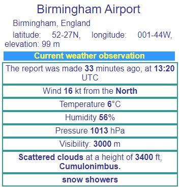
Air temperatures are well above freezing this afternoon, but snow is still falling in some places, for example Birmingham on recent METAR below:
Dew points are useful for forecasting snow. Generally a dew point of 0C or below is required for snow to fall. The dew point also accounts for why we sometimes get snow at surprisingly high temperatures in spring – like the next few days. A cold airmass in spring can often be dry too, with dewpoints of -3C, so although the stronger sun in spring heats up the surface, leading to a significant rise in air temperature after perhaps being below freezing overnight, in a dry and cold airmass there is no significant change in the dew point. So potentially the air temperature may reach +7C with a dew point of -3C, and the relative humidity falls considerably as a result.
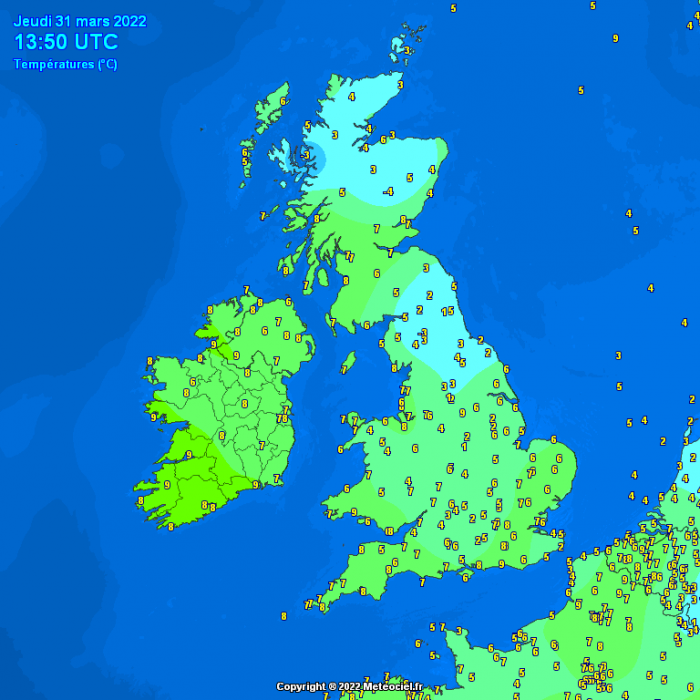
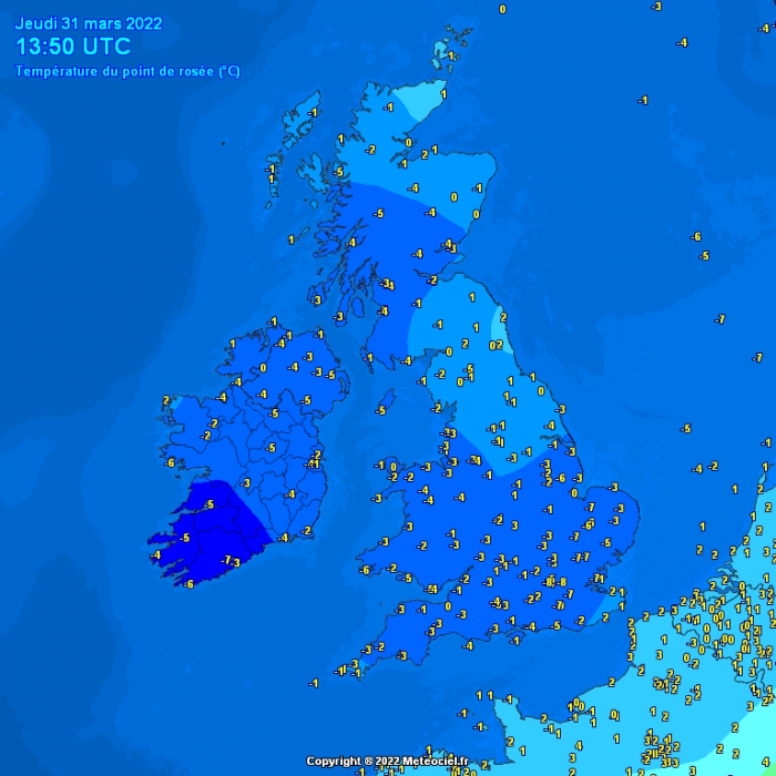
Dew points widely below 0C across the UK Thursday afternoon, so snow more likely to reach the ground intact if temperatures lower enough in heavier showers
So, when a wintry shower comes over, the low relative humidity and the sharp temperature gradient just above the surface enables falling snowflakes to reach the ground without melting significantly. Though in heavy showers, it doesn't snow at 7C for very long because the downdraughts associated with the showers and evaporative cooling allow the temperature to fall very quickly as the shower gets underway.
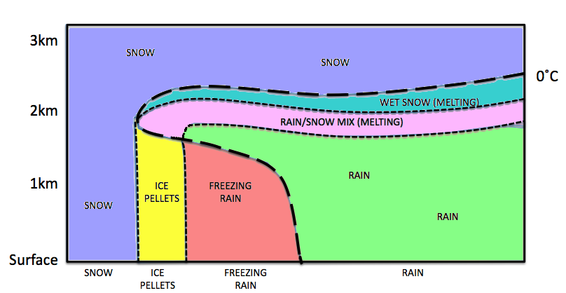
High up, where the clouds are, it’s always cold, so generally most of what falls in the UK starts off as snow. As the snow falls to lower levels it can turn to rain – this occurs below what is known as the freezing level. During wintry cold spells from the arctic or Siberia, the freezing level lowers towards sea level, allowing snow to fall to low levels. However, the freezing level may not lower enough in marginal situations, so lower levels see rain or sleet while hills that stick up above the freezing level see snow. So, the height of a location above sea level can have a significant influence on whether it will snow or not too. Generally, the higher up a hill or mountain – the colder it gets, roughly a 1C drop in temperature for every 100m gained in height. When the freezing level is just above the ground, whether over higher ground or lower levels, then that’s when forecasting snow can be tricky, particularly when precipitation becomes heavy and evaporative cooling takes place – lowering the freezing level. It can still snow below the freezing level too to a certain depth, as it takes a lot of latent heat energy to melt snowflakes, of which there is not much in a cold airmass.
 Source:ECMWF Forecast User Guide
During a cold spell, the sea is relatively warmer than the air, so temperatures in coastal areas are often higher than further inland. So, while it may snow 5-10 miles inland from the coast, along coasts it may rain instead – thanks to warming from the sea.
I’ve already mentioned evaporative cooling helping lower the freezing level and thus allowing snow to fall to lower levels. Evaporative cooling occurs when liquid water evaporates, this requires taking thermal energy from the surrounding air to change from a liquid to gaseous state, thus cooling the air. This is how sweat keeps us cool - when it evaporates, it takes in heat from your skin.
This process is most effective when winds are light, because denser colder air descending from aloft isn’t mixed with less cold air from elsewhere. The precipitation intensity further aids this process, light rain is less likely to turn to snow as heavier rain, because less moisture means less evaporative cooling to lower the temperature and freezing level.
It is not unusual to for wild swings between spring warmth to winter chill at this time of year. Below are some of the more notable flips from an early taste of spring back into winter in March or April:
2021 - A plume of warm air from the south allowed temperature to reach 24.5C in Kew, London on 30th March, generally there was widespread warmth across the south at the end of March. April was then cold, colder than March on average nationally. Snow fell on the 12th, as far south as London.
2013 – Trawsgoed, Ceredigon, west Wales reached 17.5C on the 5th. However, from around the 10th, a very cold easterly flow developed sourced from Siberia. Heavy snow fell on the 11th and 12th on the south coast and even Channel Islands, further snow brought disruption to NE England and eastern Scotland mid-month. Between 22nd-24th saw the most significant snowfall, as Atlantic frontal systems bumped into the cold easterly flow, bringing prolonged and heavy snow to north Wales, northern England, SW Scotland and N, Ireland
2001 – Cardiff reached 17C on the 7th, with a mild spell lasting until mid-month, but just when it seemed like winter was left behind, cold returned from mid-month, as a bitterly cold easterly flow developed. 10cm of snow fell in Powys on the 17th, also significant snow in the south on the 20th, as Atlantic fronts bumped into the cold air.
1989 – After a warm end to March, with Canterbury reaching 20.7C on the 28th, an area of high pressure developed over Scandinavia from April 1st, which ushered in unusually cold air from the east for a few days, with London seeing snow on the 5th, 18cm of snow at Tadworth (Surrey) on the southern edge of London.
1981 – The first half of April was sunny and warm, particularly in the north, Easter was cloudless, but soon after northerly winds set in, sweeping cold arctic air south on the 22nd. There was a maximum of only 1C on the 24th at Leeming (Yorks) and Nottingham. Significant snow fell across the Pennines, Midlands, West Country, central southern and SW England between the 24th and 26th, blizzard conditions across the Pennines with 20’ drifts across the Peak District.
1975 – Highs of 14-15C were recorded in England and Wales during the first week. But, by contrast, the Easter Holiday (28-31) was cold, with showers of snow, sleet or hail. There was snow cover in places during the holiday. Cold northerlies with snow showers continued during the first 10 days of April too, with lying snow in the southeast on the 9th.
1968 – A late March heatwave saw the temperature reach 25.0C at Cromer, Norfolk on the 29th, thanks to southerly winds. However, 4 days later, it was snowing in London and parts of SE England, after a cold front moved south on the 2nd of April, with a low of -10.6C recorded at Achnagiochan (Strathspey) that morning.
Loading recent activity...