


February 2022 will be remembered for its cluster of three storms. Dudley, Eunice and Franklin, their impacts and disruption. There were red warnings, gales, rain, snow and England’s highest ever recorded gust of 122mph at the exposed Needles lighthouse. This succession of Atlantic lows led to large rainfall totals and severe flooding for northern England, the Midlands and particularly along the River Severn. February was also milder than average, more so for England and Wales and completed a milder than average winter.
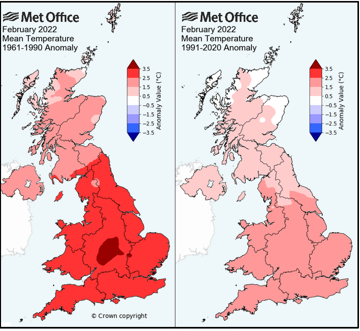
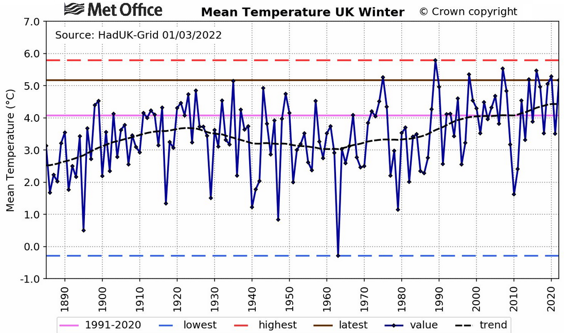
The image shows this February’s mean temperatures compared to two different 30 year periods. Our warming climate is almost downgraded by only looking at the latest anomaly period.
“Based on provisional data, it was the UK’s eighth warmest winter in terms of mean temperatures on record in a series from 1884… it was fourth warmest for both Northern Ireland and Wales, while England and Scotland were both ranked ninth. This means half the top ten mildest winters on record have now occurred since 2010. “ MO
All that mild air resulted in southern Britain feeling snow-starved this winter. There were snow showers for Northern Ireland, northern England and plenty for Highland Scotland in cold flows from the northwest. Northern Scotland has seen heavy snowfalls which caused distribution and school closures. Snow fell at times throughout the month with Storm Eunice giving a good covering as the warm front pushed northwards, up against cold air.
North-South views. Any snow left? "quite a lot actually, surprisingly. Seems the Eunice snow created a decent base with a bit more staying power than anything else this winter." Moray.
And a plea from Essex "please send some snow down here forgotten what it looks like."
Snow showers from the west and northwest have appeared during February 2022
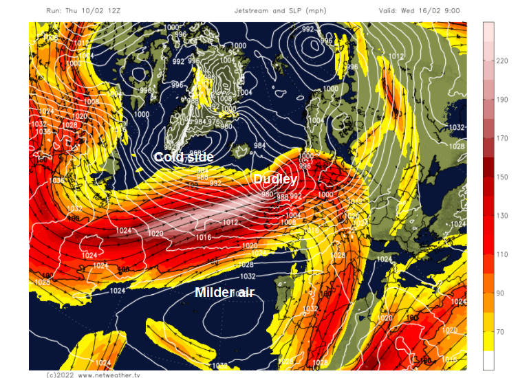
The last weekend in January had brought Storm Malik (named by northern group) and Storm Corrie (named by our western group) but it would then be two weeks until the UK Met Office announced a double whammy of Dudley and Eunice being on the way. Storm Dudley hitting the UK on 16th/17th February and Storm Eunice on Friday 18th.
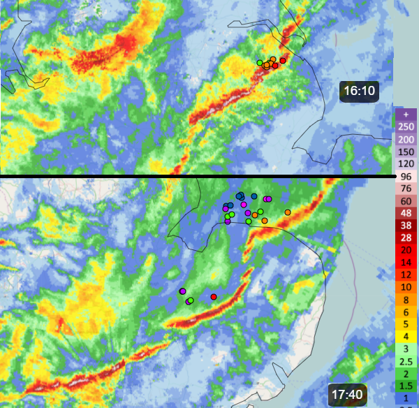
February was overall quite mobile. Not dominated by high pressure but with the Jetstream to the north or in the stormy spell coming right at the UK, there were plenty of low pressures whizzing by, active cold fronts and changes in temperature. Cold polar air brought the sleet and snow showers, but frontal bands often took their time to reach SE England. The temperature contrast NE to SE often enhanced line convection along these fronts which gave sudden gusty downpours. Storm Franklin started with one of these on Sunday 20th February. (Radar below)
Earlier in the month with the Jetstream away to the north, it was Iceland getting hit by deep winter lows and seeing many warnings for blizzard conditions. High pressure lurked over the Azores and Iberia which led to more settled conditions in the south of the UK, but windy weather further north. It was relentless. The vigorous lows did manage to sweep their weather fronts right down through the British Isles and into mainland Europe. This happened right after Storm Franklin cleared with wild conditions for Reykjavik late Monday 21st and the Icelandic low extending wet and windy weather to the UK by Tues 22nd. The month was busy and mobile. High pressure wasn’t anchored nearby, the Atlantic was active and the perception north to south of this month will be contrasting.
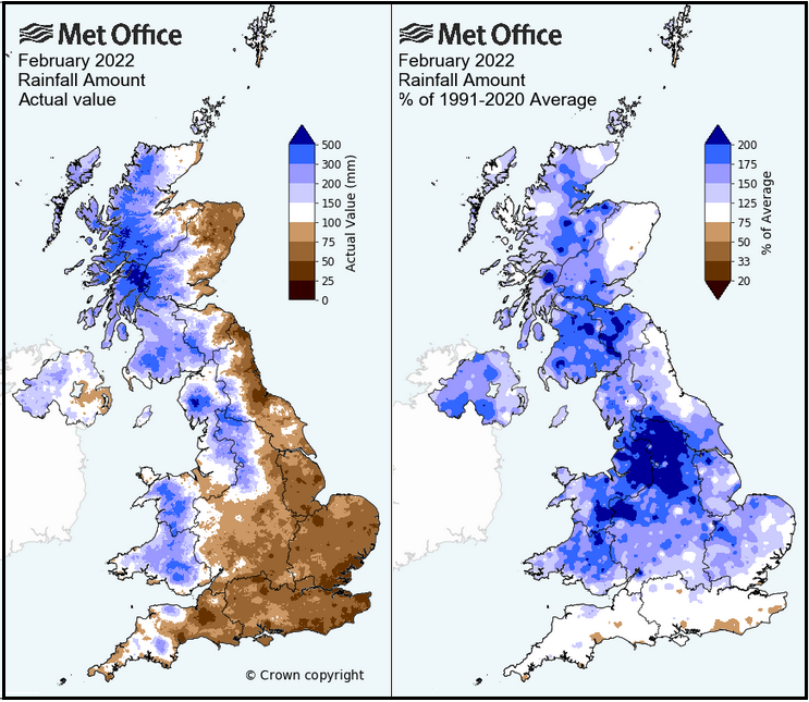
The winter rainfall was around average however February saw about one and half times the average rainfall for the UK and the four home nations. Looking at the Actual rainfall you can see that varies greatly. Eastern Britain was drier, which you would expect in a mobile Atlantic low with SE Britain also dry. Looking at the February rain, the dark blue areas stand out, where over 200% of average rainfall fell. It wasn’t like February 2020 when nearly the whole of the UK was dark blue and saturated although this time the Environment Agencies and council teams still had to put into place a large preventative response, along many rivers.
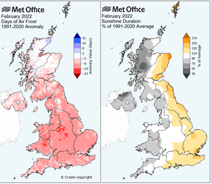
Western areas were duller with eastern Britain being sunnier than average. There were also fewer frosts than average, particularly for Wales and central Britain although the far north of Scotland was more frosty.
There has been snow and lots of windy weather for Scotland, certainly north of the Central Belt. Parts of central Britain saw a lot of rain and so flooding. And the south will feel winter hasn’t really happened this year. Onwards to spring.
Loading recent activity...


.png?w=767)

.png?w=175)