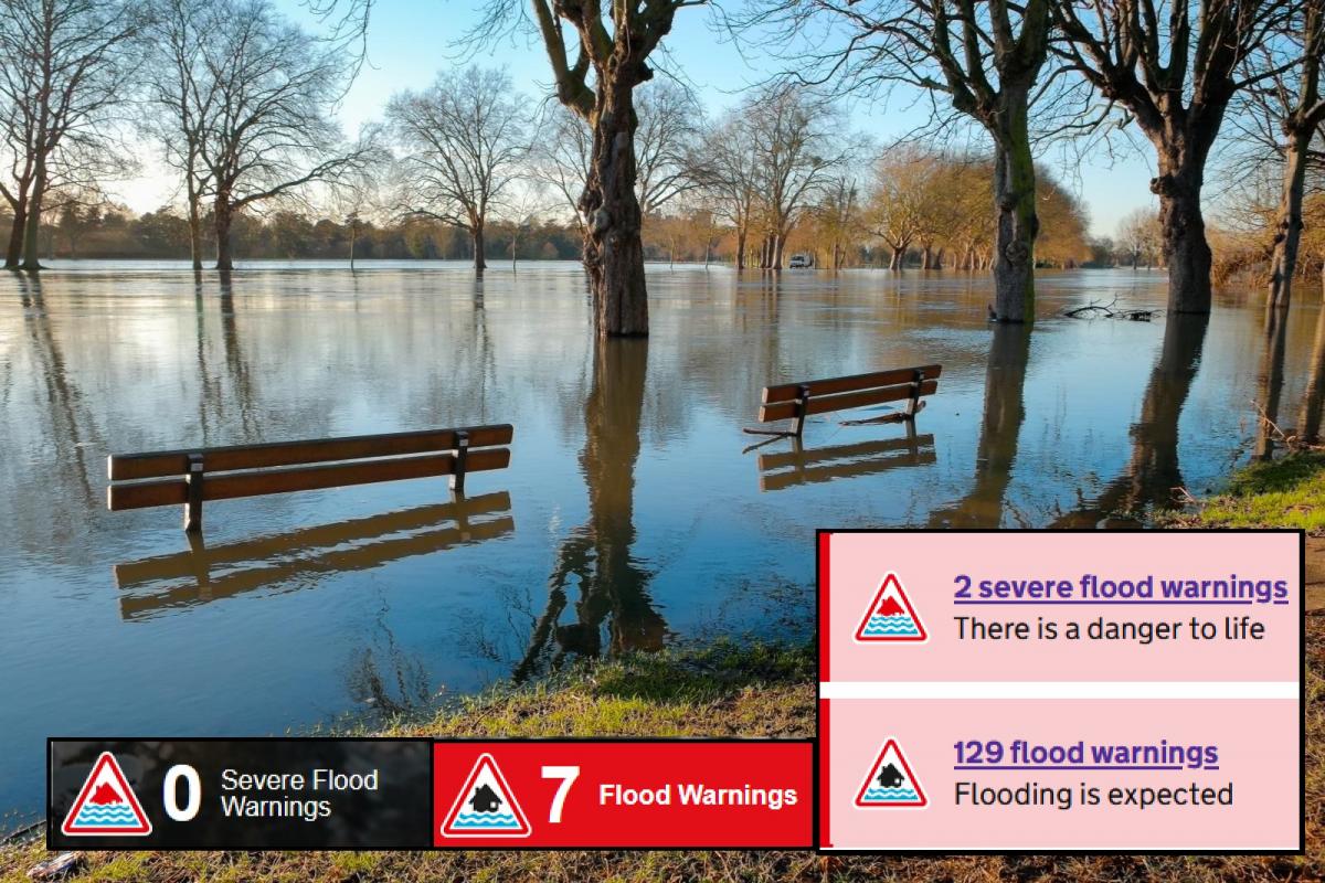
After the recent three named storms, parts of the UK were left with bulging rivers, flooded roads and tired emergency response teams. The wild gales and high gusts of Dudley, Eunice and Franklin did cause disruption and damage, but it was the recent rainfall that is still causing widespread flooding issues. Particularly for northern England, the Midlands and Wales. The River Severn is a slow responding waterway and Ironbridge has just seen a severe flood warning issued (Mon 3pm) with evacuations starting. Update 5pm- Second Severe Flood warning now for Bewdley, Shropshire, again for temporary flood defense concerns of over-topping.
“Residents in flood-risk areas urged to evacuate with support from police and council… a peak river level Tuesday evening which could be higher than the flood barriers. “ Env. Agency
The rainfall wasn't exceptional on Sunday but the catchment areas are now saturated. Some of the official river gauges have recorded their highest ever river levels. So, record heights from data stretching over 30 to 50 years. The Environment Agency with council teams have been tending to flood defences. South Manchester saw two severe flood warnings at the weekend with numerous other alerts and warnings. There have been many videos of those who decided to chance it, driving through floodwaters, yet ran the risk of wrecking their engines or having to be rescued, inconveniencing or even endangering others.
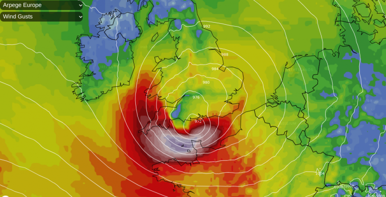
This succession of storms has brought all types of flooding. Coastal flooding as large waves from Storm Eunice battered western shores and a tidal surge moved up the Bristol Channel and into the Severn Estuary. Sunday’s torrential rain from a squall line on Franklin’s cold front brought sudden heavy rain with violent gusts, even lightning as it passed by. This meant poor visibility and surface water flooding as the roads and pavements struggled to drain away.
On Monday, the Thames Barrier had to close due to a tidal surge as the low centre of Franklin moved southwards over the southern North Sea. This extra push adds to the water levels in the Thames estuary as the sea basin gets shallower.
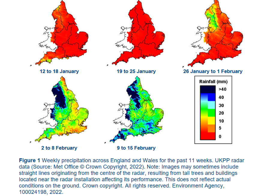
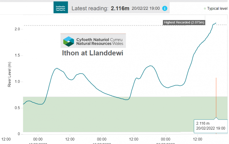
It has been the river flooding over the weekend into Monday which has been the main issue. With the active Atlantic throwing low pressure after low pressure our way, February 2022 has been much wetter than January. This onslaught has led to the current situations on the River Severn, Ouse, Derwent, Don, Wye, Wharfe and others.
The flooding issues have continued this week, as the Environment Agency tweet shows. Where rivers come together there is excess water. The Severn is a slower responding river than others, hence issues until Wednesday. People in these areas live with this risk and each time barriers and flood prevention measures are put in place but with our changing climate, can this continue? There will be more, heavy and prolonged rainfall. We saw lengthy spells of dry, settled weather under high pressure with little wind last year, even water scarcity concerns. And now it’s like the wind never ends and there is flooding.
Ironbridge is highlighted above "as extremely high river levels on the River Severn threaten to over-top barriers "with very fast flowing waters.
“The Agency deployed temporary flood barriers along The Wharfage at the weekend, which are expected to divert the majority of the flood water. However, there is still a high risk that some water will breach the top of the defence.” EA
The forecast into Tuesday includes another cold front from a storm over Iceland tonight. However, this will bring heavy rain to western Scotland and Northern Ireland but should weaken as it reaches northern England and Wales after dawn. There is a bit more rain each day for the Welsh mountains, the Pennines, Dales and Peaks. It’s not heavy or prolonged, (around 10mm on Tuesday morning, still unwelcome). These warnings relate to rainwater from the storms slowly making its way down through the river systems.
Floodline number 0345 988 1188
Loading recent activity...