
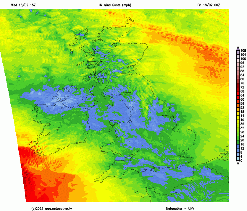
Two named storms are affecting the British Isles this week in quick succession. Storm Dudley today and overnight into tomorrow morning, though this first storm quite as bad as feared it might be, but still packing a punch of strong winds across northern England, southern Scotland and N. Ireland this evening and overnight before winds ease Thursday morning. Gusts of 60-70mph likely quite widely inland, 70-80mph over hills and around coasts. Capel Curig outside of the Met Office amber warning area in North Wales has seen a gust of 80mph. Some travel disruption from these strong winds are likely this evening. But it's the second storm, Storm Eunice, arriving on Friday that is of more concern, with potential for unusually strong and damaging wind gusts affecting more heavily populated areas of southern and central England during the day, as well as Wales.
Summary
A low is forming this evening way out west over the North Atlantic to the southeast of New Foundland and is expected to rapidly deepen during Thursday and overnight into Friday morning, as it comes under the influence of a powerful 200mph+ jet stream – which will take it towards and over the British Isles during Friday. The strongest wind gusts look to be across England and Wales on the southern flank of the deep depression by then – which looks to track northeast across southern Ireland, north Wales then northern England before moving out across the North Sea Friday evening. There is a high probability of gusts between 60-70mph inland across Wales, central and southern England, perhaps up to 80mph in a few places. Along the coasts of west Wales and SW England gusts could be even higher, with 90-100mph possible. Coastal flooding on the high tides is likely around southern and western coasts of England and Wales, given huge swell created by Eunice deepening over the Atlantic.
A Met Office Amber Warning is in force for much of England and Wales south of a line from Lancaster to the Humber. This may be upgraded to a RED warning nearer the time, given the potential for 100mph wind gusts in the southwest.
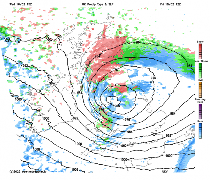
Snow will be an additional hazard across the far north of England and southern Scotland on the colder northern flank of the deep low, with blizzard conditions possible over high ground.
Detailed analysis
The ‘embryonic’ stages of the low that will form Storm Eunice can be seen as an emerging cloud head along a distinct frontal zone on satellite imagery this evening over the Atlantic to the southeast of New Foundland.
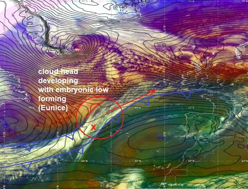
A potent upper trough of cold polar air, that exited NE Canada earlier in the day, is engaging a baroclinic or frontal zone lying between the British Isles and towards Bermuda. This frontal zone separates cold polar air streaming out of northern Canada and warm sub-tropical air streaming northeast towards the UK from Bermuda and the Caribbean.
A low forms this evening along the frontal zone, as the arrival of the upper trough causes cyclonic shear along the part of the front near the developmental right entrance quadrant of nearby jet streak, where air diverges aloft and converges at the surface - causing the front to buckle – generating a spinning motion and a low pressure circulation along the front.
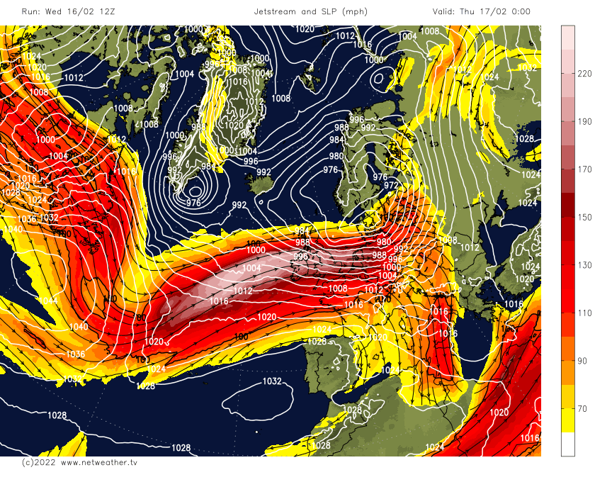
The low then continues to deepen (cyclogenesis) on Thursday - as it is forced northeast by the confluent upper trough advancing east over the North Atlantic and carried by a strong jet streak moving northeast. The low then undergoes Rapid Cyclogenesis (RACY) from Thursday evening overnight into Friday morning, as it moves into the highly developmental left exit region of a strong 200mph+ jet – where strong upper level divergence is created, causing air to rise from the surface to fill the void by air fanning out from the jet streak aloft, thus lowering pressure at the surface.
Watch Eunice rapidly deepen in the left exit of a strong 200mph+ jet streak
The rapidly deepening low looks to be of the Shapiro-Keyser type cyclone, as opposed to the more classic Norwegian cyclone type. The Shapiro-Keyser type is characterised by rapid deepening in their early stages, whilst the Norwegian type are slower to deepen.
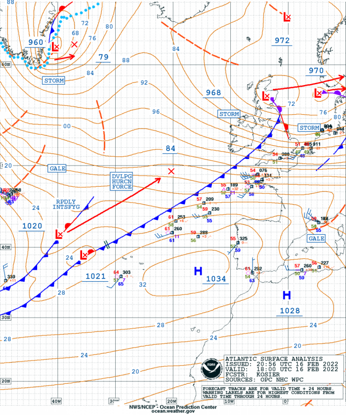
So after the wave has formed along the frontal boundary, warm air protrudes northward and starts filling the centre of the deepening low at lower levels. The northern part of the warm front is stretched around the warm core of the Shapiro-Keyser cyclone, while cold air continues moving rapidly towards the southeast and the cold front detaches from the warm front – causing a cold frontal fracture. This can be clearly seen on the fax chart below for 00z Friday.
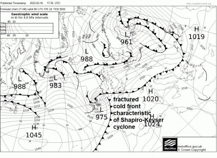
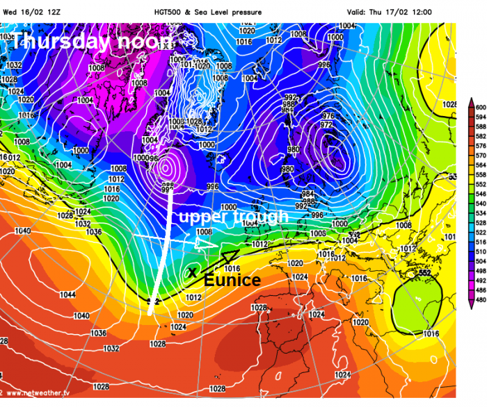
Storm Eunice low sees central pressure drop of 22mb in 12 hours (between 12z Thursday and 00z Friday). Rapid cyclogenesis is classified by a central pressure drop of more than 24 mb in 24 hours, so clearly this is very rapid deepening.
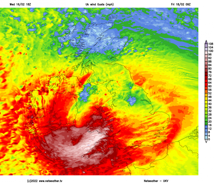
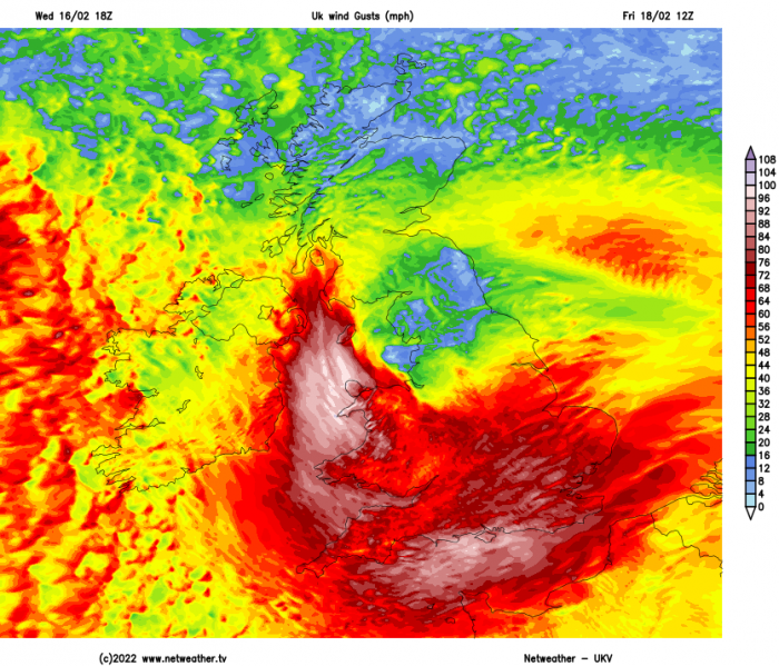
Models are now coming into general agreement of the track of the Eunice low on Friday. It will continue to rapidly intensify as it moves northeast across southern Ireland during the morning, before crossing the Irish Sea then NW England middle of the day before exiting NE England during the afternoon.
Wind gusts of 60-70mph are likely widely inland across England and Wales south of a line from Manchester to Humber, across south Wales, south Midlands, southern England and East Anglia UKMO shows gusts between 70-80mph between 9am and 3pm. Across northern coasts of Cornwall, Devon, the Bristol Channel and southern coasts of south Wales gusts between 80—100mph are progged. These are damaging wind gusts, so I would recommend only the most essential travel, the best advice is stay indoors, work from home if you can and cancel any non-essential journeys between breakfast time and late afternoon.
As well as the damaging winds, heavy snow looks like it could cause some issues across northern England and Scotland, particularly over higher ground. Cold air will be in place across northern Britain ahead of the Eunice low moving in from the southwest and will also wrap around the low on the western flank as the low clears. Up to 5cm is possible at lower levels, up to 30cm above 250m.
I can’t emphasis enough that this is a significant storm with potential to cause widespread damage and travel disruption, despite the news giving very little airtime this evening. Take care!
Loading recent activity...


