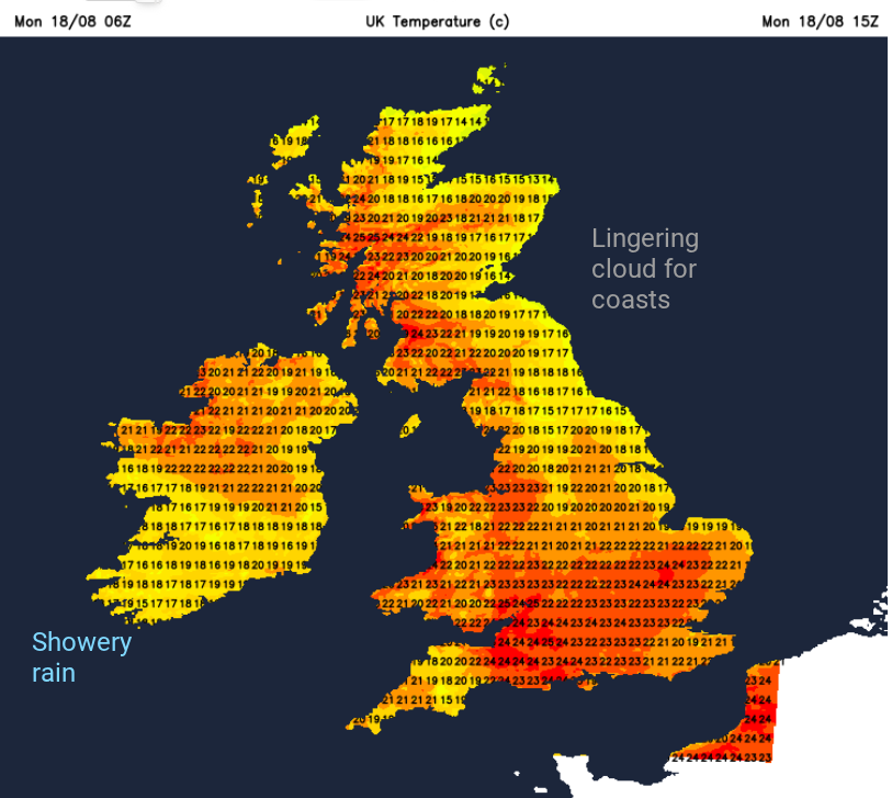
The weekend certainly delivered on August sunshine. The crowds at the Edinburgh Fringe (and organisers) would have been delighted, although there is a grey start to Monday morning. Southwestern Britain saw the highest temperatures at the weekend, tipping over 27C. It wasn’t the intense heat of last week, but still above average. The southwest will continue to see the top temperatures this week thanks to the positioning of high pressure. Here, there will be shelter and more sunshine. It will be a different story for North Sea coasts. Around the high pressure, centred near Iceland, there will be a northeastern flow which helped steer this blanket of cloud over parts of Britain for Monday morning.
Anyone who lives or holidays in eastern Britain will know the summertime drill. A grey, cooler start but the day does usually brighten up, the cloud thins and breaks and by later morning, often enough, the sunshine is back. However, this cloud could be quite stubborn along North Sea coasts and quick to move back inland later this afternoon. For Tuesday, the cloud looks thicker and likely to bring some patchy rain.
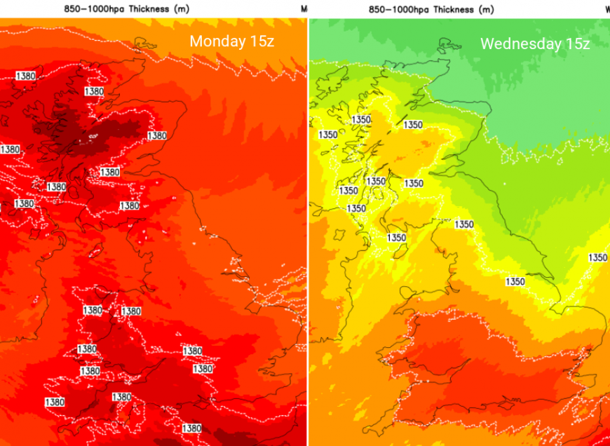
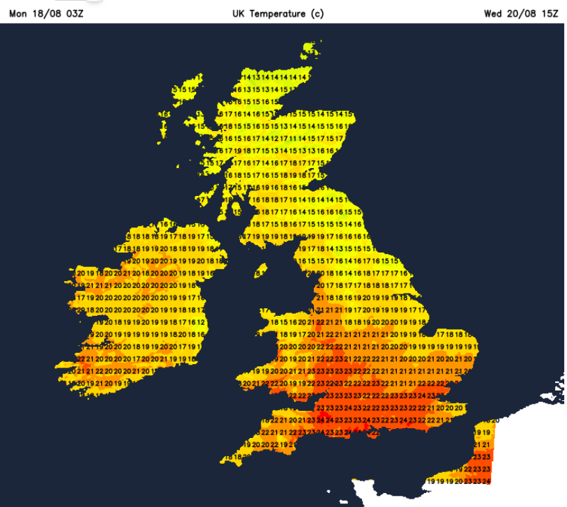
A change in airmass by midweek, with a cooler air flow from the north by Wednesday
For those areas that did qualify for an official heatwave last week, it was a combination of lots of sunshine heating the ground and warming the surface air in calm conditions and a southerly feed of the hot air. High pressure kept things steady with only light winds and often clear skies. This European heat has pushed temperatures over 40C in southern France and Iberia, with terrible fires spreading wildly amongst the dry vegetation. There have been evacuations in Spain, Portugal and Greece due to the spread of the fires.
For the UK, we are going to see a distinct change in air flow, which will be most noticeable for northern and eastern Britain. By midweek, cooler air will approach from the north. Starting for the Northern Isles on Tuesday afternoon with a northeasterly wind and then extending down through eastern Britain on Wednesday. The winds will back to a northerly for East Anglia as they fall light over most areas. Early on Thursday, there will be clear skies, hardly any breeze and this cooler air from the north, allowing inland rural spots to fall down into single figures. The same again early on Friday morning, perhaps colder for Grampian.
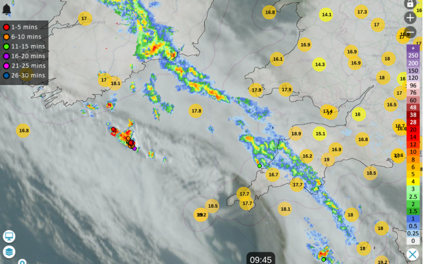
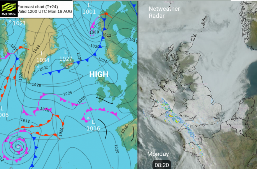
Netweather Radar showing the line of showers on Monday morning over Devon and Cornwall with a few sferics, extending over Ireland
There is very little rain in the forecast this week. There is a line of showers over Devon this morning, due to very warm air at the surface and cooling aloft. There have been a few lightning strikes today and there will be more showery outbreaks, even thundery ones, tomorrow for Cornwall, the western English Channel and the Channel Islands. Météo France has many thunderstorm warnings for Tuesday to add to the ongoing orange Heatwave warnings in the south.
The damp and grey weather from the North Sea will continue into Tuesday evening, making its way inland for England. As this feed continues from The Wash across to the M4 by night, there will be clear spells elsewhere.
So two things change this week; we won’t always have the wall-to-wall sunshine which lifts the temperatures day on day. Some parts of the UK will stay fine with sunny spells and will feel warm. Wednesday looks sunny again. We also have this change in airmass, no longer with the feed of hot air from the south. For many areas, it brings the temperatures back closer to average for late August. The lack of rain continues, although with showery outbreaks at the start of the week for southwest England and patchy rain on Tuesday in the cloudy flow off the North Sea. It’s not good news for the overall water picture in the UK.
Loading recent activity...