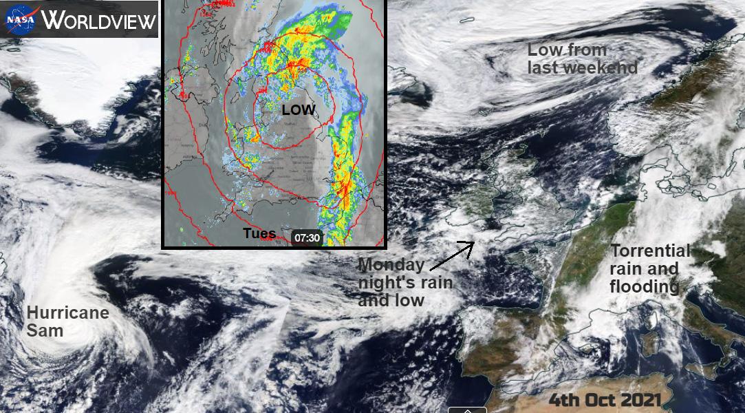
Parts of Southeast England and London awoke to flooded streets after a noisy night of torrential rain and gusty winds. This was from an active front that had made its way across southern Britain and was continuing to soak NE England and SE Scotland on Tuesday morning. London recorded 35mm of rain before 8 am and there was traffic disruption with so much water on the pavements and streets which also affected the railways and tube network. Knightsbridge was flooded with water lapping up at shop doorways and the M23, A4 and A3 had closed lanes with stranded cars
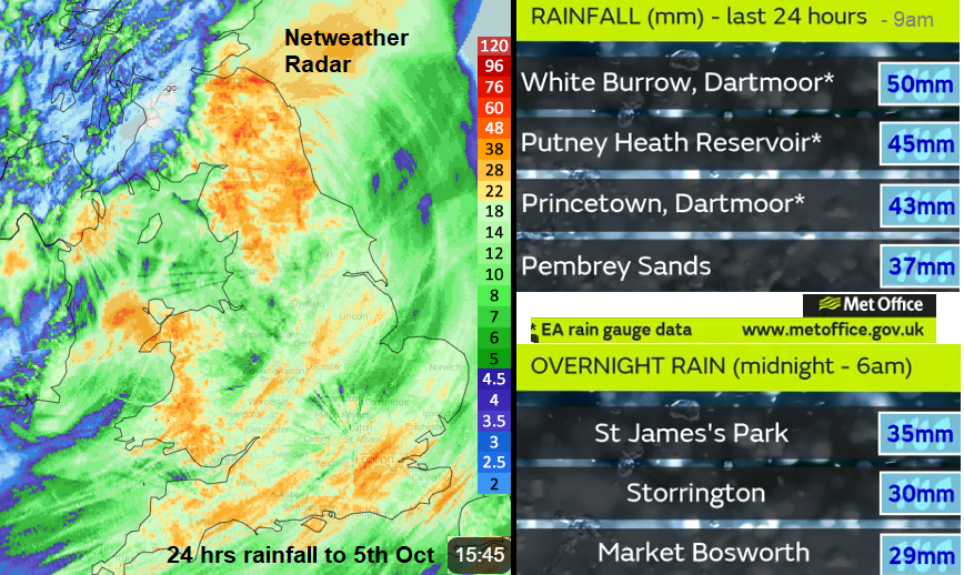
As Tuesday continued the heavy rain affected more of Britain with SE Scotland and NE England getting particularly soaked. Chillingham, near Alnwick Northumberland, recorded 74mm in 24 hours which is 3" of rain. There were other localised flooding issues as the rain just kept on coming and the day seemed to never get light.
Flooding can happen when the drains are overwhelmed, rivers burst their banks especially if there has been heavy and persistent rain recently. Cities and urban areas will be affected by torrential rain more than areas where the water can run off easily and soak into the soil. The drains need to be maintained but it is projected that with climate change the UK will see warmer and wetter winters (half of the year) and more frequent and intense weather extremes.
Once again, we’re seeing the impact of the climate emergency on our doorstep. In London we’re leading from the front to tackle this crisis, and I’ll continue to urge other politicians here and around the world to take the action that’s desperately needed. pic.twitter.com/6OM9aJ7bGa
— Mayor of London, Sadiq Khan (@MayorofLondon) October 5, 2021
Autumn heavy rainfall will happen, there will be storms and flooding, but climate change can add an extra slice on top, enhance these events just a shade further. And they will occur more often. The cost and impacts increase unless there is adaptation and also (as we hope to see from COP26) mitigation.
There had already been wet weather at the weekend, off and on, from a low pressure over the UK which went on to affect more of Europe. Its frontal band (with a secondary low) brought torrential rain on Sunday to France, particularly the south and then to northern Italy by Monday. Heavy thunderstorms brought huge amounts of rain, devastation from flooding and left landslides even when the worst of the rain was over.
Rossiglione in Liguria, north-western Italy, recorded 925.8mm of rain in 24 hours on Monday. 740,6 mm falling in 12 hours was a new European record (29" of rain). Just 35 mm fell in London overnight and caused flooding and travel disruption. These huge Italian totals swept away bridges, houses and roads with nearly 500mm of rain in 6 hours at Montenotte, a new Italian record.
As this low deepens and moves over more of Italy and the Adriatic this week, it will stay very unsettled for the central Mediterranean and Balkans but high pressure over Russia will manage to settle more of Europe including most of the UK.
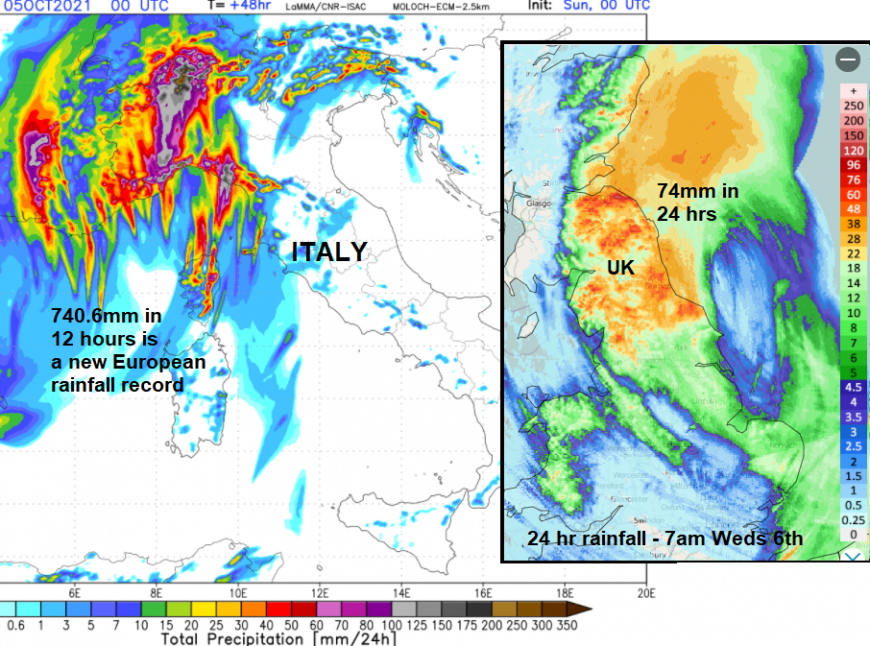
Total 24 hr precipitation for Italy 4th July and 24 hr UK rainfall until 7am Weds 6th
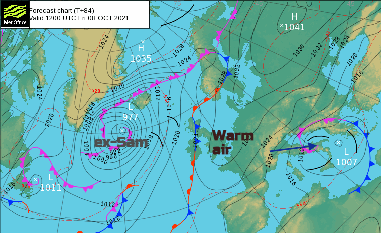
The NW of the UK is in for some potentially heavy and persistent rain from frontal bands linked to ex-hurricane Sam. The centre looks to be doing a magical mystery tour south of Iceland. As Tuesday's UK low pressure finally moves away from the east coast of Britain on Wednesday, taking its heavy rain and strong winds with it, the now extratropical low of ex-Sam will throw its warm front in from the west on Wednesday and then it's cold front will continue to wave about right into the weekend. Plenty of uncertainty here but the potential for some heavy rain. There will be warm air ahead of this system lifting temperatures across the UK.
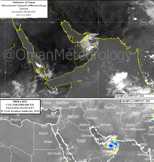
Another tropical rainmaker has been Cyclone Shaheen. This started its life as Cyclone Gulab over India but as its remnants moved over the Arabian Sea (a different Region) it was renamed Shaheen and took a rare path. It moved into the Gulf of Oman and affected Iran and Oman with at least 13 people being reported to have died in the mass of water. Many more are missing as torrential tropical rain fell on hard-baked ground. Others were affected by the high winds, blowing dust around and causing injuries and breathing problems.
Streets were submerged and buildings damaged in the flash flooding, schools closed, and flights were cancelled. Even as the storm has weakened inland the clear-up operation will be huge and includes the capital Muscat. "Al-Khaboura, also northwest of Muscat, received 369 mm of rain within 24 hours. This is roughly the normal precipitation for five years in this desert area."
Loading recent activity...