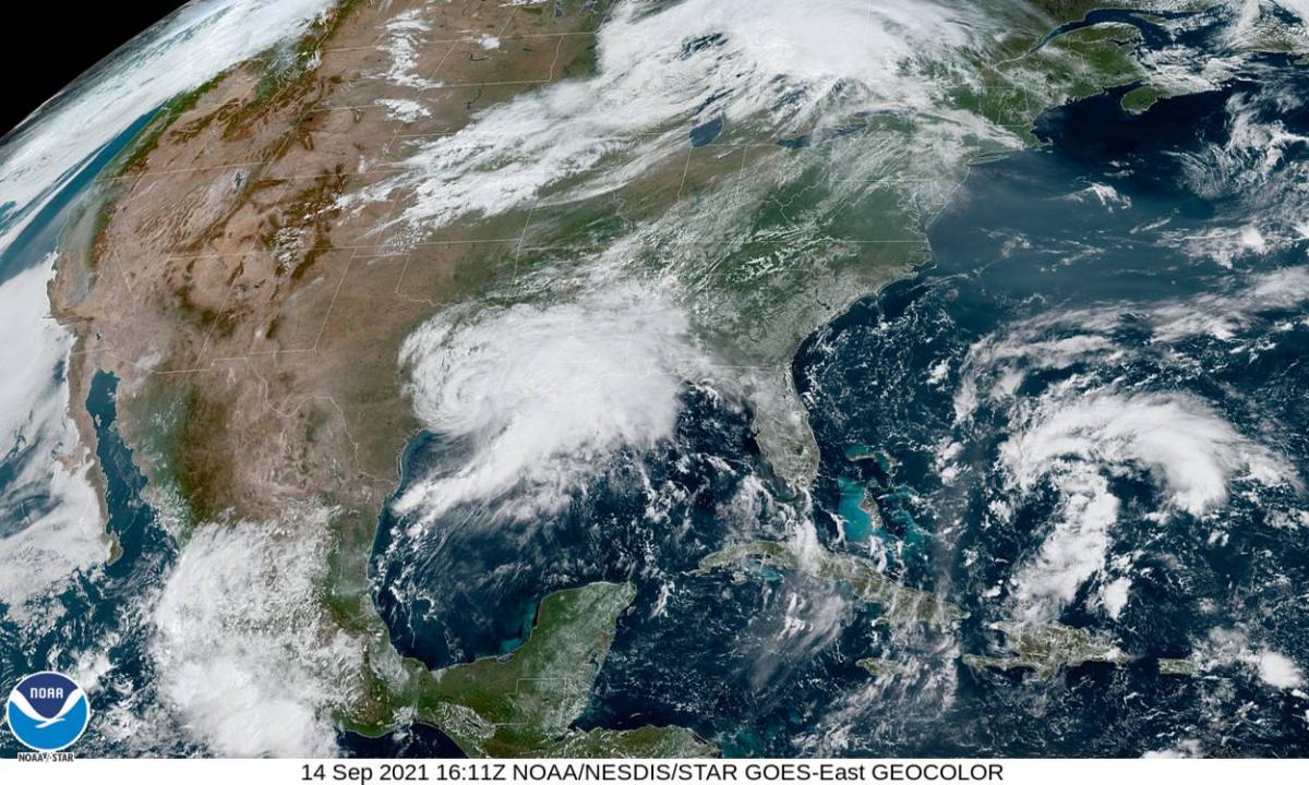
Tropical Storm Nicholas made landfall on the Texas Gulf coast briefly as a hurricane early Tuesday morning and, although now weakened, will bring up to 15 inches of rain to parts of Louisiana still recovering from Hurricane Ida a few weeks ago.
As if the residents of Louisiana needed any more rain. Parts of the state are still recovering and repairing after the floods unleashed by Hurricane Laura and Delta last year, then recently the life-threatening flooding and wind damage in the south of the state caused by Hurricane Ida – which made landfall as a category 4 storm in the state on the 29th August. There are big concerns again for more flooding in Louisiana over the next few days, as Tropical Storm Nicholas moves slowly across the state on Wednesday before weakening on Thursday. 3-5 inches of rain is forecast to fall widely across the state, but across central and southern Louisiana 5-10 inches may be common, maybe up to 15 inches locally. Though forecasts seem to vary. This could lead to life-threatening flash flooding in places.
Nicholas made landfall as a category 1 hurricane on the coast of Texas Monday night, with 75 mph winds, before downgrading back to a Tropical Storm, as it lost wind intensity moving inland. Regardless, Nicholas is likely to unleash very heavy rainfall bringing life-threatening flash flooding to parts of southeast Texas, central and southern Louisiana for the rest of this week, as it takes a slow path northeast along the upper Texas coast and towards western Louisiana today and into tomorrow – then the storm is expected to linger over central to southern Louisiana on Wednesday and Thursday.
Nicholas made landfall briefly as a hurricane at Matagorda Peninsula (90 miles southwest of Houston) early Tuesday morning, bringing a dangerous storm surge resulting in coastal flooding and sustained winds of 75mph, with higher gusts. Nicholas is moving slowly north-northeast from the Gulf coast at a speed of 8mph and the centre of the tropical storm is now moving over the Houston Metro area as of typing Tuesday afternoon. Over 400,000 customers are without electricity in the Houston area of Texas, as Nicholas packs sustained winds of 45 mph, with higher gusts. The storm has already dropped a lot of rain along the upper Texas coast so far today, with Galveston recording 9.7 inches of rain, with 6 inches widely falling between here and southwest Louisiana so far today.
Flooding rainfall will be the greatest risk from TS Nicholas over the next few days, as the slow-moving storm funnels large amounts of deep tropical moisture from the Gulf of Mexico inland as it moves northeast, bringing torrential rainfall on the north and northeast side of the storm between Houston, Texas and into southern and central Louisiana, including New Orleans, from now through to Wednesday night. Rainfall of 4-8 inches forecast for far southeast coastal corner of Texas today, locally more. But as the heaviest rain moves away from southeast Texas, attention turns to Louisiana from now on, where the highest rainfall totals will be from now until Thursday, with up to 15 inches falling locally in southern Louisiana. This is likely to lead to localised flash-flooding, exacerbated in areas where debris from Hurricane Ida a few weeks ago has not yet been removed and may be blocking normal drainage.
Isolated tornadoes, higher tides bringing coastal flooding and strong winds will be additional hazards on top of the primary threat of heavy rain leading to flash flooding across SE Texas and Louisiana over the next few days.
The map below, from NWS New Orleans, highlights potential areas of high rainfall in Louisiana over the next few days, though it should be noted that different models and forecasts vary over where will see the highest totals.
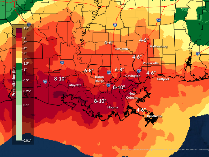
Parts of southern Louisiana are likely to bear the brunt of the heaviest rain over the next few days, the same area is still reeling from the damage caused by Hurricane Ida that struck at the end of August, with power restoration and recovery work still ongoing. There are still some 95,000 customers still without power across Louisiana as of Tuesday morning. Some places in the state are even still repairing the damage caused by Hurricane Laura and Delta that hit last year too.
There are suggestions from some scientific circles that these tropical systems are becoming, on average, slower-moving over recent years, perhaps attributable to climate change changing weather patterns making this more likely.
Meteorologists are also keeping an eye on a tropical wave of thunderstorms moving out of Sierra Leone out over the tropical eastern Atlantic – which has a 70% chance of developing into a tropical depression in the next two days and 90% chance in the next 5 days. Also there’s another disturbance just north of the Bahamas, where an area of low pressure has had its chances of developing into a tropical depression grow in the last 12 hours, 30% chance in the next few days to 60% in the next five days. This is expected to move north but keeping away from the US eastern seaboard for now.
Loading recent activity...