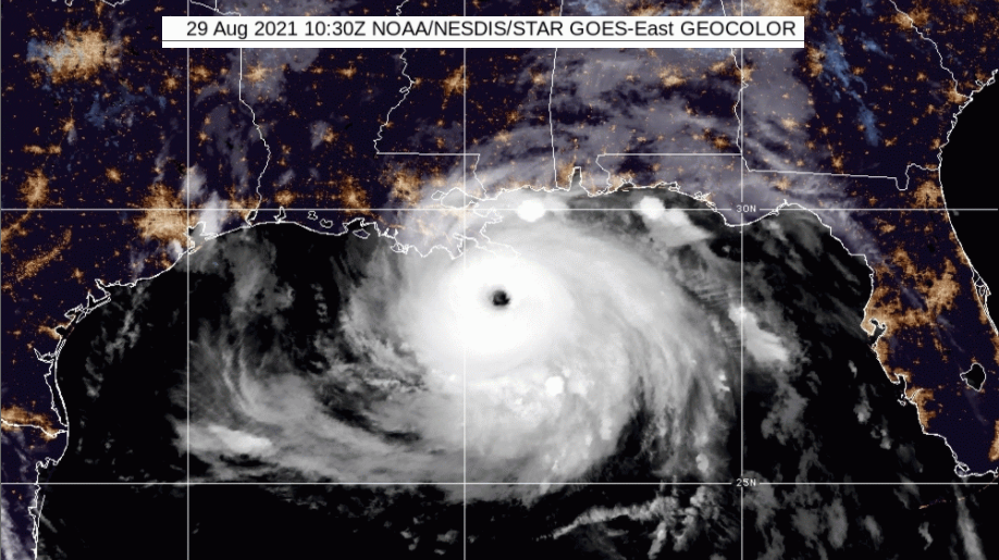
Hurricane Ida has intensified to a high Cat.4 over the warm waters of the Gulf before landfall on Sunday 29th . Louisiana, New Orleans and Mississippi are waiting.
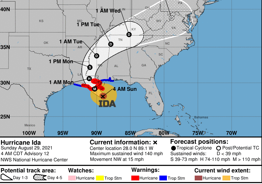
Hurricane IDA - "continues to strengthen and now has maximum sustained winds of around 150 MPH with higher gusts, and a minimum pressure of 935 mb" NHC 12Z 29th August 2021
Residents of Louisiana and southern Mississippi are finalising their hurricane preparations. Sorting emergency supplies, preparing for major power outages and flooding. Those who can leave have been advised to go, others will have to await the storm surge and destructive winds.
Hurricane Ida has already made landfall passing over western Cuba on Friday with wild conditions and flooding from the storm surge. Next, rapid intensification is expected over the warm waters of the Gulf of Mexico to major hurricane status. The upper-level wind pattern is favourable, there is plenty of moisture and the ocean heat content is very high along the way. Ida could reach Category 4 before it hits the Gulf Coast of the US on Sunday 29th August.
This will be sixteen years to the day when the catastrophic Hurricane Katrina hit this region with the devastating flooding and storm surge. Katrina had suddenly intensified to a Category 5 on approach before making landfall as a Category 3. A breached levee resulted in 80% of New Orleans being flooded. Katrina remains the costliest US hurricane with millions left homeless and estimates of 1,000 to 1,800 people dying in the event, mostly in Louisiana.
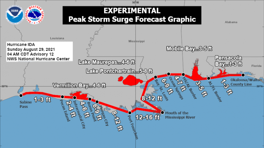
The main concerns from Hurricane Ida will be:
Storm Surge
“Danger of life-threatening inundation, from rising water moving inland from the coastline. Persons located within these areas should take all necessary actions to protect life and property from rising water and the potential for other dangerous conditions. Promptly follow evacuation and other instructions from local officials.” NHC
This storm surge is expected to raise the water levels by as much 5-15 ft in the warnings for Louisiana. The deepest water will occur along the immediate coast near and to the east of the landfall location. Overtopping of the local levees is possible in a wider area. Residents of New Orleans who live outside the city’s levee system have been ordered to evacuate. Those inside have been told there isn’t time to set up the highway procedures for a mass evacuation of the city and so should “hunker down”. Louisiana has seen some mandatory evacuations of towns and coastal areas. The surge will be accompanied by large and destructive waves.
“Extremely life-threatening inundation of 10 to 15 feet above ground level is possible within the area from Morgan City, LA, to the Mouth of the Mississippi River.” NHC
Hurricane Winds
Ida is expected to be an extremely dangerous major hurricane when it reaches the coast of Louisiana. The highly populated area of New Orleans is under the hurricane warning now which also includes the far SW corner of Mississippi.
“Potentially catastrophic wind damage possible where the core of Ida moves onshore. “
Residents are being reminded that preparations to protect life and property should be completed before conditions outside make preparations difficult or dangerous. And there isn't much time left. The winds are expected to pick up during Saturday night, into early Sunday with the Hurricane conditions forecast for the northern Gulf Coast on Sunday 29th.
Sometimes the various weather models show different paths or timings, and this lowers the confidence in the forecast and makes evacuation order decisions more difficult. For Ida, the models show very good agreement. Ida is forecast to make landfall in Louisiana late Sunday or early Monday morning, local time. The storm will then move inland heading north then northeast. “there is high confidence in the track forecast.” NHC
Once Ida makes landfall it will slow and weaken, without the energy source of the warm Gulf waters, drier air and increased wind shear up through the environment. Ida will continue to bring heavy rain and some areas have already seen terrible flooding this month.

Rainfall
Through Sunday Ida will bring heavy rain over the land. Accumulations of 8-16” with even isolated 20” is possible in the south through Monday. This will lead to flash flooding as the heaviest rain areas move inland.
There will be a busy start for this weekend along the Gulf coast but then on Sunday it will be a case of wait and see for the residents of Louisiana, New Orleans and Mississippi.
Atlantic Hurricanes- Your complete guide
Typhoons, cyclones and hurricanes around the world
Netweather community thread Hurricane Ida
Loading recent activity...