An unprecedented heatwave is currently gripping the Pacific Northwest of North America, with temperatures some 30F above normal for late June over the past weekend and the last few days. The heat has not only been widespread across Northwest U.S.A and Canada’s British Colombia but also unusually intense, with temperature records widely broken by double digits Fahrenheit.
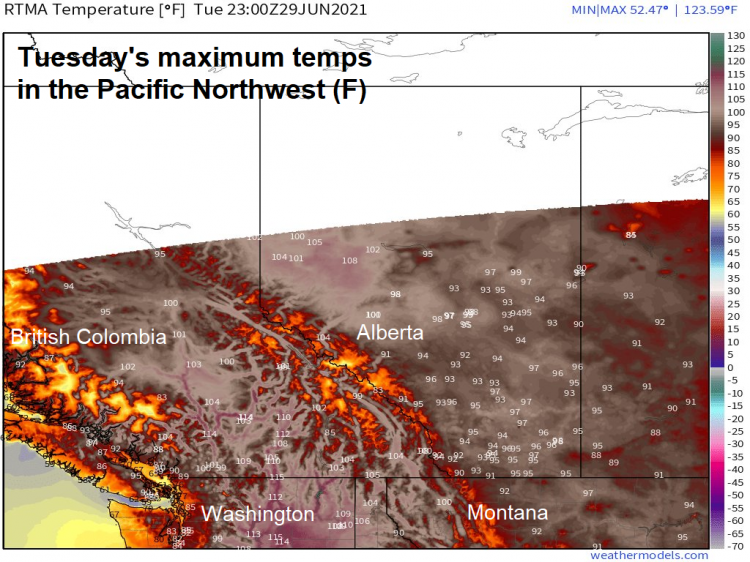
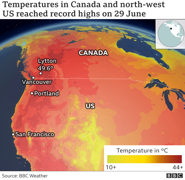
Lytton in the southern interior of British Colombia and in the foothills of the Rockies broke Canada’s national high temperature record for a third day straight on Tuesday 29th June, reaching 49.6C (121F). Previous to this heatwave, Canada’s national high temperature record was 45C, set on July 5, 1937. Sunday, the town reached 46.6C, then broke this record again on Monday, by reaching 47.9C (118F), surpassed by Tuesday, which was just shy of 50C. This is higher than the Las Vegas all-time temperature record of 47.2C, a city much further south in the Desert Southwest of the U.S.A. The town's location in a valley between mountains trapping heat building under high pressure. To add to Lytton's woes, a raging wildfire threatens, with the town's Mayor ordering an evacuation of the town.
Many other places in the Pacific Northwest have smashed their high temperature records by 5-10C, which is unprecedented. The worst of the heat has extended through British Colombia in Canada and south of the border into the U.S. states of Washington, Oregon, Idaho, Montana and California. As well as Lytton in BC reaching 49.6C, Portland in Oregon broke its all-time record three days in a row. Monday reached 46.6C (116F). Salem to the south reached 47.2C (117F). Seattle set a new record with a high of 42.2C (108F). Numerous other locations in Washington and Oregon states have broken all-time records by large margins.
“We’ve never seen anything like this before," said Dustin Guy, a meteorologist with NWS’s office in Seattle. “We’ve only had three days of 100 or more degrees in 126 years, and it looks like we’re ready to get three of them in a row now. There’s really nothing to compare it to. We’ve never in anybody’s lifetimes seen anything quite like this before in Seattle."
The Pacific Northwest is more used to a more temperate climate like the British Isles, with mild and sometimes rainy weather as low pressure systems roll in from the west, so many houses, like in Britain, lack air conditioning, which makes this extreme heatwave even more deadly. This issue not just the exceptionally high daytime temperatures, the nights haven’t cooled down much in the Pacific Northwest. So opening windows makes little difference with people’s bodies unable to cool and recover from the exposure to heat during the day. This can lead to potentially life-threatening stress on people’s health if they do not find somewhere to cool down during the day.
The high wet-bulb temperature has also been a contributing factor to the rising sudden death toll induced by the extreme heat. The wet-bulb temperature is the temperature read by a thermometer covered in a water-soaked cloth, kind of mimicking human skin, over which air passed over it and is technically defined as the temperature of a parcel of air, cooled to saturation by evaporation of water into it. The higher the wet-bulb temperature, the lower the human body’s ability to efficiently shed heat and cool down. The body’s natural way to cool down is to sweat; the ambient heat of the air evaporates the sweat, which helps cool us down. But if the air is 100% humidity with a high wet-bulb temperature, the air cannot soak up any more water, so sweat on the skin does not evaporate, leading to the body overheating. 35C (95F) marks the upper physiological limit a human body can withstand, around or above the body will overheat. But values much lower than this can have serious health implications. The combination of high humidity / wet-bulb temperatures and high temperatures in the Pacific Northwest means those exposed to such high heat and humidity for long periods are at risk of serious health issues or even death.
The exceptional heat has been caused by a ‘heat dome’, a large and deep area of high pressure caused by an omega-shaped block in the wavy jet stream. Exceptional 500 hPa heights (the air pressure at 6,000 metres) in excess of 597 dm were recorded in the ridge of high pressure over British Colombia – which is historically intense for this area in late June. The sinking air within this intense high pressure block or heat dome compresses the already hot air on the ground, exacerbated by winds blowing downward off the Rockies towards the Pacific coast, rather than cooler winds blowing in from the ocean, further enhancing the heat which is trapped under the blocking high. Deeper and more intense depressions or tropical cyclones over the North Pacific, strengthened by warmer ocean temperatures through the climate warming, could be behind the stronger-than-normal high pressure systems and associated heat domes that develop.
Statistically, the Met Office has calculated and said such an event to be a once in tens of thousands of years occurrence in a climate without human-induced climate change, but now these sort of events could occur every 15 years with AGW. So, what would seem to be an extremely rare event will become more probable to occur again in areas not used to such extreme heat in coming years and decades.
The intense heat dome high pressure system is forecast to shift east across the Rockies to affect Alberta, Saskatchewan and Manitoba as well as the northern Plains of the USA, cooling off a little near the Pacific coast. Still, it will remain hot inland across British Colombia for the rest of the week and into the weekend, before winds turn westerly over western Canda next week, bringing in cooler Pacific air to the interior too.
Loading recent activity...