A Major Sudden Stratospheric Warming (SSW) occurred today over the Arctic. A SSW is a reversal of the zonal winds from westerly to easterly in the polar stratosphere, driven by the Stratospheric Polar Vortex. The reversal of winds in the polar stratosphere is marked by a dramatic spike in temperature, by as much as 50C, occurring at high altitudes above the North Pole. The warming is often triggered by strong poleward and upward energy from waves in ridges and troughs of the upper flow forming lower down in the troposphere further south in the mid-latitudes.
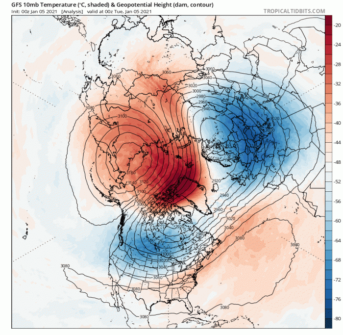
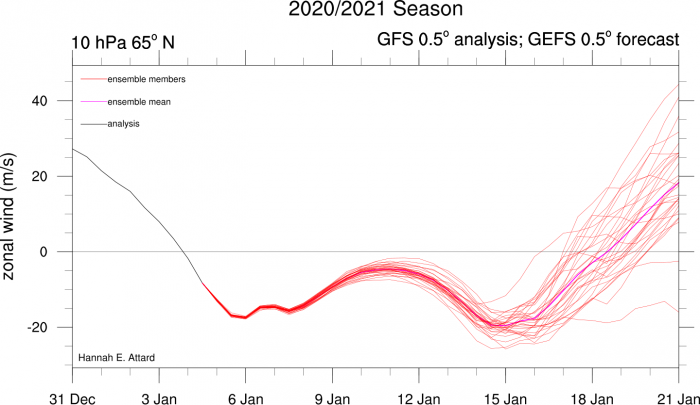
A SSW is technically defined to have happened when the mean zonal wind at 60°N and 10hPa (approx. 30km high) reverses to easterly. This reversal can be seen on the graph below, where the 10 hPa zonal wind goes below 0 m/s (switches easterly):
A SSW event usually has a significant impact on the troposphere patterns in the mid-latitudes, where our weather patterns occur. Following a SSW, the weakening of the polar vortex and switch to easterly winds can eventually extend down towards the top of the troposphere. This eventually leads to a weakening of the tropospheric jet stream and can be followed by a switch to easterly winds in lower altitudes of the mid-latitudes to bring associated cold conditions over northern Europe and/or North America and these impacts can be long lasting.
ECMWF model shows easterly winds (in blue) descend from the stratosphere toward the troposphere over the polar region (far right):
However, every SSW is different and around 66% of them lead to colder conditions, so not all SSW events lead to cold. For example, the SSW in February 2018 led to the ‘beast from the east’ later that month and into early March, whereas the SSW in January 2019 had no significant impact for the UK and NW Europe, due to the easterly winds in the stratosphere not propagating down into the troposphere. In fact, it stayed mild for the rest of the winter.
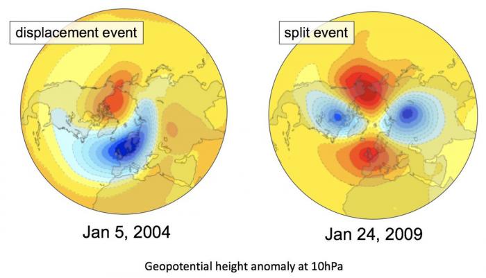
It can take anything between 2 to 6 weeks for the impacts of the SSW to work its way down 30-50km up, so there are no clear indications yet that the current SSW will lead to cold and wintry conditions later this month. Also, the duration of the reversal of zonal winds of a SSW, which ultimately determines how much impact it has on the weather patterns, is affected by whether it is a displacement of the Polar Vortex or a split of the Polar Vortex. The Polar Vortex takes longer to recover from being split than being displaced. So, split SSWs tend to cause the longest periods of unusual weather; 3-6 weeks, as opposed to 1-4 weeks for displacements. The current SSW looks to cause a displacement of the Polar Vortex towards Europe, but a renewed warming in the coming days could split the Vortex.
We have, of course, been and currently are in a cold spell of weather, but this is not related to the SSW, though the tropospheric upper patterns that have brought the cold spell, which set in following Storm Bella clearing on Boxing Day night, has likely helped provide poleward energy that has impacted the stratosphere to bring on the SSW. The current cold spell has brought some snow in many places along with some hard frosts, with the lowest temperature of the cold spell so far dropping to -10.2C in the Highlands of Scotland. The cold weather looks set to continue for the rest of the week and into the weekend, with some snow in places Thursday and Friday along with a risk of frost. However, later in the weekend and into next week, milder conditions look to spill in from the Atlantic, as high pressure that's been across the north declines southwestward, the milder conditions initially across northern areas before reaching all parts through early next week.
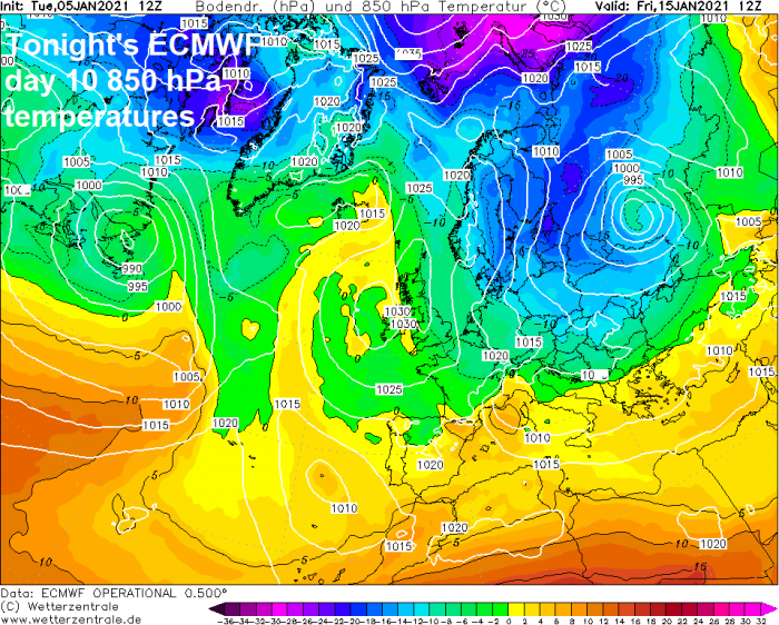
There is not currently any strong signal yet from model guidance for much colder weather to return later this month after a return to milder conditions from early next week. Though the last few ECMWF deterministic runs have hinted at deep cold building over Scandinavia and eastern Europe in 10 days time - which may come west to the UK if the upper flow, which flattens out next week, becomes more amplified again.
But it should be noted that there are other drivers controlling our weather patterns, particularly tropical forcing such as La Nina and MJO/Indian Ocean convection background forcing and currently a strong Pacific jet stream which is likely behind the return of a more mobile Atlantic pattern with milder conditions next week. If the SSW doesn't quickly impact the troposphere, or it may impact NW Europe unfavourably for colder weather (SSWs have been implicated in bringing mild southwesterly winds to the UK too), then we could see milder weather for a few weeks or more.
So don't read too much into recent hype headlines from some media proclaiming the Beast From The East is coming due to the SSW. The current SSW may not lead to the same bitterly cold weather that we saw in late February / early March 2018. There is no guarantee that this event will bring the same as already discussed.
To follow the current talk about the Sudden Stratospheric Warming, there is a thread dedicated to it here:
Loading recent activity...