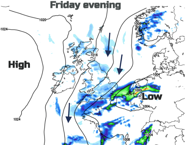
Another low which looks to deepen as it moves away from the UK on Friday evening bringing us cool north winds. Some fair weather over the long weekend though, just not that warm.
A brief midweek lull as Storm Francis clears away eastwards and the clear up of trees and branches continues. There will be more rain as heavy showers get going around another low pressure Thursday into Friday. Not a storm like Francis but more wet weather on wet ground with already lingering puddles.
The low pressure does look like it could deepen Friday night over the southern North Sea as it moves away from SE Britain. It could impact the Netherlands (or northern Germany) whose Met service KNMI is in the same Name our Storms project with Met. Eireann and the UK Met Office. Three in a row? Ellen, Francis and would be Gerda? Just getting carried away now with this unusual August weather although it would be nice for KNMI to sneak a 'Naming' this season. There will be a noticeable northerly wind for Friday night and Saturday for the Low Countries and Britain.
So, after a midweek lull the next low moves in. Your weather app may not do well with the timings of showers during Thursday or Friday but there will be a spell of more unsettled weather with heavy even thundery showers by Friday, particularly for England and Wales. East Anglia and SE England look particularly prone on Friday evening if you are eyeing up outdoor pub bookings for the weekend.
High pressure will be building out west, starting off the more settled theme for the weekend but in between, we have this cool northerly flow which if you are camping take note. It might be drier by day, after a soggy week but the air will be cool, especially by night although the sun’s rays still have strength and warmth as the winds become light. You’ll need everything, warm jumper and hat, sunglasses and sunscreen.
There will be a few showers in the northerly flow, coming down coastal areas, but not reaching inland too far in the west nor for central Britain. Eastern England could be a bit more mixed, especially for Saturday morning. Eastern Suffolk, Essex and Kent could stay very windy through Saturday night, depending on how the Friday low develops.
For much of the UK, high pressure will be in place and that means settled, fair weather with light winds, bright spells but temperatures in the high teens, just up to 20 or 21C. Cool considering what August can offer.
For Bank Holiday Monday for those who do have the day off, it looks to start fine but there is a frontal band of wet and windy weather heading in from the Atlantic and it seems to be speeding up. So over Ireland during the morning now. Something to watch but most of Britain could still manage another fine day.
Meanwhile, in the US, the southern Gulf coast is bracing itself for the arrival of major Hurricane Laura.