As a deep Atlantic low moves across Ireland and the UK there will be another August spell of wet and windy weather. Heavy rain will bring a risk of flooding and with strong winds possible travel disruption.
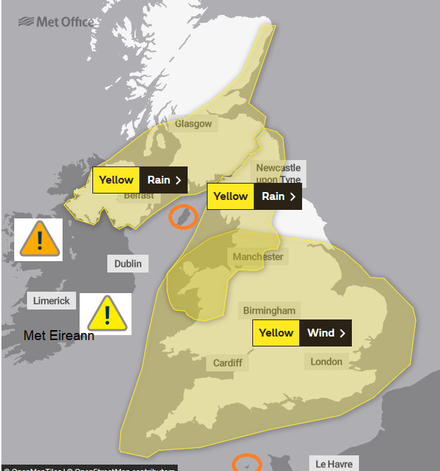
Another week in August, summer 2020 and another named storm. Storm Francis this time. An Atlantic low which will move over Ireland and the UK on Tuesday 25th bringing very wet and windy weather. There is already a collection of weather warnings for rain over Ireland, Northern Ireland, parts of Scotland, the Isle of Man, northern England and NW Wales. Wind warnings for Ireland, Channel Islands, Wales and much of England with other parts of the UK seeing some miserable wet and windy conditions. If you can delay plans by a day it may well be worth it.
This low pressure was named by the UK Met Office this time (Storm Ellen by Met Eireann last week). There wasn’t an Amber warning out at the time, although lows can be named if an Amber (or Irish orange warning) is likely. There are now Orange warnings from Met Eireann out for strong winds but no Amber for UK yet.
Anyway, there will still be some unseasonal weather with heavy and persistent rain bringing the risks of flooding and travel disruption. The strong winds will be gusty and together, it won’t be very nice on the roads, camping or if you were planning a day trip. Another wet playtime for many Scottish schools which isn’t ideal. Northern Scotland escapes the worst of the weather on Tuesday morning becoming wet and windy later, the far NW misses most of the storm.
Rain
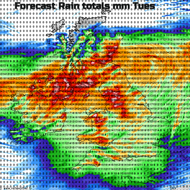
Met Eireann - Intense rainfall associated with Storm Francis is expected at times Monday night and Tuesday. The most intense rainfall is expected to ease off in southern counties during Tuesday morning. Some flash flooding likely.
The rain will move up from SW Britain during Monday night, through Wales and Ireland. By Tuesday morning it will be over much of England, into southern Scotland and Northern Ireland.
Met Office - Storm Francis will bring some very strong winds leading to disruption to travel and power supplies along with potential damage to trees. Heavy rain is expected during Tuesday and early Wednesday and is expected to result in some flooding and disruption to travel.
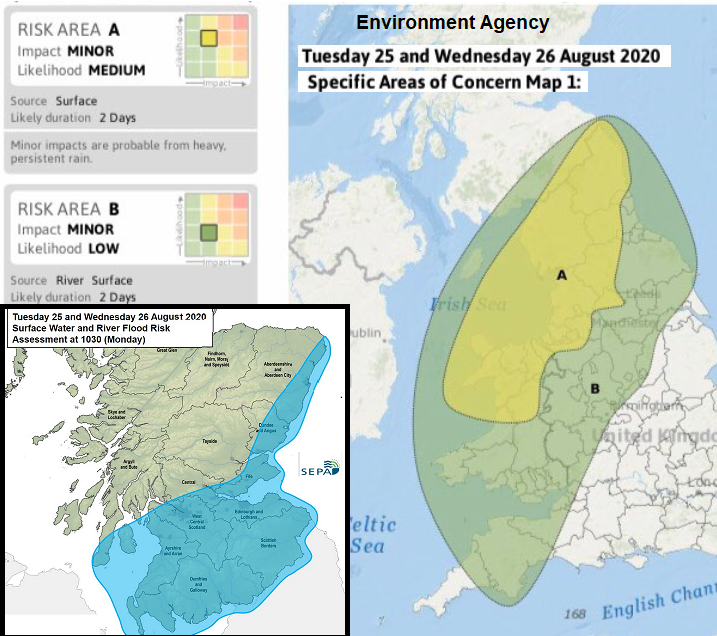
Although the cold front rain will clear eastwards from England, the occluding frontal bands will continue to bring heavy rain over Northern Ireland and the southern half of Scotland as the low slows. NW Wales and NW England also see more rain and there are flooding concerns due to surface water and about the river levels. Southern Britain becomes drier in the afternoon, with a mixed picture for Northern Ireland, Wales and northern England as clusters of heavy showers are driven by. Eastern Scotland and the Central Belt stay wet into the evening but gradually as the low centre slips eastwards there will be some improvement. Showery in the north overnight with rain slow to clear NE England, SE Scotland on Weds morning but by lunchtime, the last of the rain will be dragged away the east coast of England as Storm Francis heads off to Denmark.
Quite a soaking and there will be flood alerts and warnings appearing.
Winds.
Storm Francis is not developing as Storm Ellen did, with the red warning for Cork and the intense damaging core of winds. This is a windy day in August with trees in full leaf and the possibility of travel disruption, some damage to roofs and fallen trees. Care will be needed along coasts and if hill walking.
The strong gusty winds start over SW Britain on Monday night as the rain arrives affecting Wales, SW England across to the Isle of Wight on Tuesday morning. Through the afternoon it becomes increasingly windy over southern Britain with gales, even severe gales for Wales around coasts and hills and up the Bristol Channel. The winds begin to veer to a Westerly into the evening, strengthening around Kent coasts as a strong west to WNW wind picks up for north Wales and Merseyside into Lancs. And for the Isle of Manon Tuesday night.
The Isle of Man starts the day with a Amber warning for “Spells of heavy rain, accompanied by strong to gale force southeast winds, from the early hours of Tuesday morning” To the north and northeast of the two centre there will be fresh to strong easterly winds. These accompany the heavy rain and will funnel through the Forth and the Central Belt in an unusual direction. These winds will affect Strathclyde, western Scotland and Northern Ireland, backing to a north-easterly across the North Channel. This corridor of windy weather over Scotland edges northwards, hitting the east coast, spreading to central Scotland as the winds die away in the centre of the low.
Around teatime, evening rush hour there will be a calmer, drier slot around the centre of the low where the winds drop and it looks like that will be for Northern Ireland in the afternoon then southern Scotland into the far north of England. All the while the gusty winds continue around about for southern Ireland and rest of Britain.
As the low slips away from NE England, the winds and gusts take their time to ease. Eastern Scotland seeing the winds backing and the windy conditions continuing over southern Britain into Tuesday night,
By Wednesday morning Northern Ireland and western Scotland will have lighter winds but from a cooler NW or northerly direction. The rest of Britain will be blustery with westerly winds for the southern half of Britain, still strong for eastern England and fresh NW to northerly winds for northern England and eastern Scotland up to the Northern Isles. The strong winds clear SE Britain during Wednesday afternoon.
There is another low pressure forecast for Thursday into Friday which will bring more wet and windy weather adding to the wet ground from mid-week but signs for something more settled for the long weekend.
Loading recent activity...