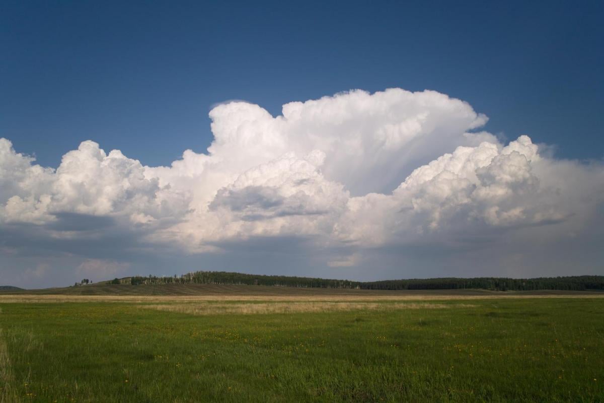
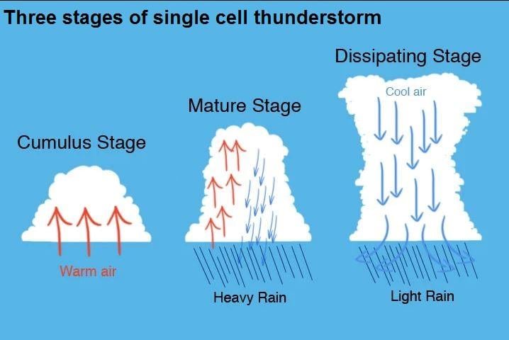
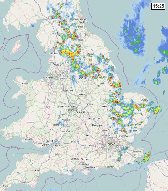
Single-cell thunderstorms - are small, brief, weak storms that grow and die within an hour or so. They are typically driven by heating on a summer afternoon. Also known as a ‘pulse’ thunderstorm, a single cell storm consists of a short-lived updraft of rising moist air that is soon cut-off by the rain falling down into the updraft turning it into a downdraft, leading to a short life of the storm. This occurs because upper winds are weak (weak wind speed shear) and thus do not tilt the downdraft away from the updraft. Usually these storms are non-severe. They may produce brief heavy rain and lightning.
Example of single cell thunderstorms across northern and eastern England
Multi-cell storms - are fairly common thunderstorms in which new updrafts form along the leading edge of rain-cooled air of the downdraft of the storm (the gust front). Individual cells usually last 30 to 60 minutes, while the system as a whole may last for many hours. Upper winds tend to be stronger than when single cells form, so downdrafts tend to be tilted away from the updrafts. These storms are generally non-severe, but occasionally they may produce isolated severe weather. These storms may produce hail, strong winds, brief tornadoes, and/or flooding.
.jpg?w=700)
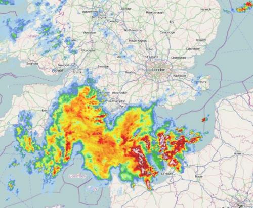
Squall line - is a group of storms arranged in a line (also known as a Quasi-Linear Convective System or QLCS), often accompanied by high winds and heavy rain. Squall lines tend to pass quickly and are less prone to produce tornadoes than supercells. They can be hundreds of miles long but are typically only 10 or 20 miles wide. They can produce severe weather, with locally damaging wind gusts in excess of 50 mph and flash-flooding.
Example of a squall line moving across Wales & SW England during July 21, 2017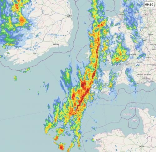
Supercell - is a long-lived (greater than 1 hour) and highly organized storm feeding off an updraft that is tilted and rotating. This rotating updraft or mesocyclone - as large as 10 miles in diameter and up to 50,000 feet tall - can produce tornadoes and large hail, as well as damaging wind gusts. Supercells usually form with a combination of strong instability and vertical wind shear (veering of winds with height) – causing the updraft to corkscrew or rotate. Usually supercells produce some or all severe hazards – which includes large hail, damaging wind gusts, tornadoes and flooding.
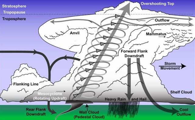
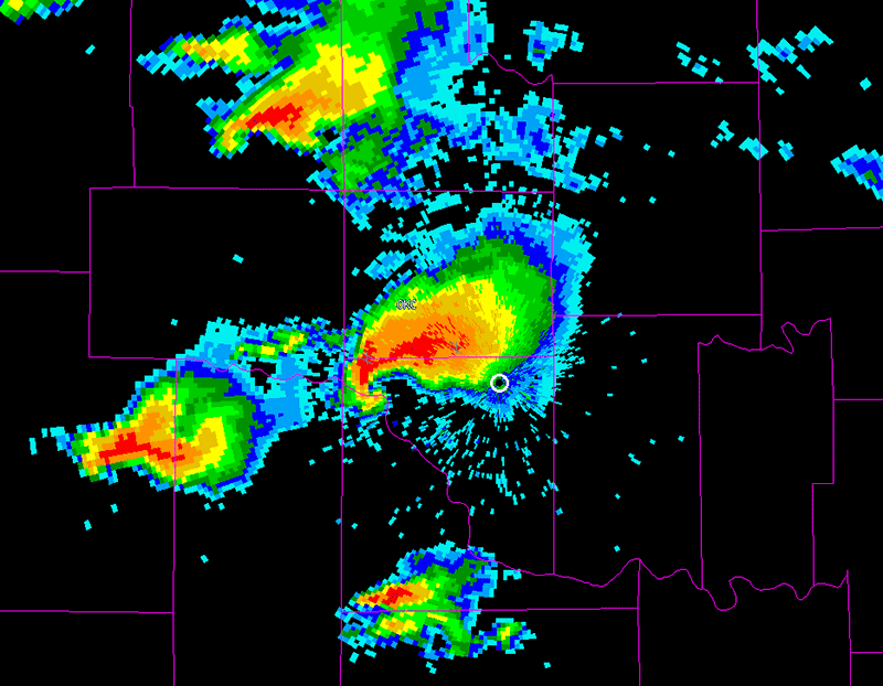
Classic radar signature of a supercell
Supercells are fairly rare in the UK, perhaps occurring one or twice a year on average, the video below is an example of one north of London on 27 May 2018:
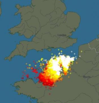
Mesoscale Convective System (MCS) - is a collection of thunderstorms that act as a system. An MCS can spread across several counties and last more than 12 hours. These storm systems can contain supercells and sometimes can develop their own low pressure circulation or Mesoscale convective vortex (MCV). These thunderstorms systems usually form and are driven by strong wind speed shear aloft, if vertical shear (veering winds with height) is strong too, embedded supercells are possible. Severe weather can be produced by these systems, particularly large hail, damaging winds and flooding, tornadoes are also possible with any embedded supercells.
Mesoscale Convective Systems in the UK are relatively rare, occurring once or twice a year on average. They are usually associated with Spanish Plume setups, more about this can be found below:
An example of an MCS approaching southern England, May 27, 2017
Derecho - is a widespread, long-lived wind storm that is associated with a band of rapidly moving showers or thunderstorms. They can produce destruction similar to that of tornadoes, the damage typically is directed in one direction (straight line winds) along a relatively straight swathe. By definition, if the wind damage swathe extends more than 240 miles (400 km) and includes wind gusts of at least 58 mph or greater along most of its length, then the event may be classified as a derecho. Given, by definition, Derechos produce damaging winds, sometimes accompanied by large hail and extreme rainfall too, they always produce severe weather, They don’t occur in the UK but can sometime occur in mainland Europe and USA with the right conditions.
Example of a Derecho crossing the Mid-West of USA, June 29, 2012
A thunderstorm which produces one or more of the following:
Severe thunderstorms, usually supercells, can develop when, in addition to rich moisture, strong instability and strong lift, the wind field the storm forms in or moves through develops strong directional and speed shear or strong vertical shear. This strong wind shear when winds veer in direction from the surface to around 700 hPa combined with strong mid to upper level winds in excess of 50 knots. The combination of strong instability and strong wind shear tends to ‘tilt’ the column of the storm cloud, displacing the updraft area from the downdraft area. This allows the updraft area to sustain for a longer period of time, as the downdraft doesn’t ‘suffocate’ the updraft, while the veering winds with height allow the updraft to rotate, causing a mesocyclone or supercell thunderstorm.
This rotating updraft or mesocyclone can suspend hail long enough to allow it grow large enough to form hail bigger than an inch in diameter. In stronger severe storms, hail can grow up to 3 to 4 inches.
Also, a tornado may form in the mesocyclone – if low-level instability becomes sufficiently strong and low-level wind shear causes a rotating updraft to narrow and spin faster to form a condensation funnel reaching the ground.
Another phenomenon that may develop in severe thunderstorms are damaging wind gusts. This is where the downdrafts of the thunderstorm can reach such speeds when it hits the ground to fan out and cause wind speeds in excess of 50 knots, causing locally damaging straight-line winds. This strong damaging wind gusts can sometimes be mistaken as a tornado circulation. The difference is usually strong straight-line winds blow one direction, whereas winds in a tornado circulation change direction as it passes.
Rainfall in thunderstorms can be very intense, leading to large rainfall totals in a short space of time over a small area – this can lead to flash-flooding, sometimes without warning, catching people out.
Yes, most years, normally on a few occasions in the warmer months, particularly summer. In the warmer months large hail, damaging wind gusts and flash-flooding are likely from severe storms, tornadoes are also not rare either but less likely. In colder months severe weather less likely, particularly large hail – as this requires lots of warmth and moisture. Tornadoes are probably more frequent in autumn and winter – particularly around our coasts.
Loading recent activity...