The World Meteorological Organisation (WMO) and ECMWF (European Centre for Medium-range Weather Forecasts) have voiced concerns about how weather models could be affected due to the reduction in observation data from aircraft as flight numbers have plummeted. “They are concerned about the quantity and quality of weather observations and forecasts, as well as atmospheric and climate monitoring. “
Observation data is input (along with the previous model run) and forecast data comes out. In between, the supercomputer does all the hard work, the weather modelling. The main source of observational data comes from satellites. The Met Office says this accounts for 90% with the rest from ships, aircraft, sea buoys and stations on land, which can either rely on a person, an observer or be automatic. They process around 100 million observations a day in normal times, these are quality controlled before a proportion of these are added to the model.
“National Meteorological and Hydrological Services continue to perform their essential 24/7 functions despite the severe challenges posed by the Coronavirus pandemic,” said WMO Secretary-General Petteri Taalas. “The impacts of climate change and a growing amount of weather-related disasters continue. The COVID-19 pandemic poses an additional challenge and may exacerbate multi-hazard risks at a single country level. “
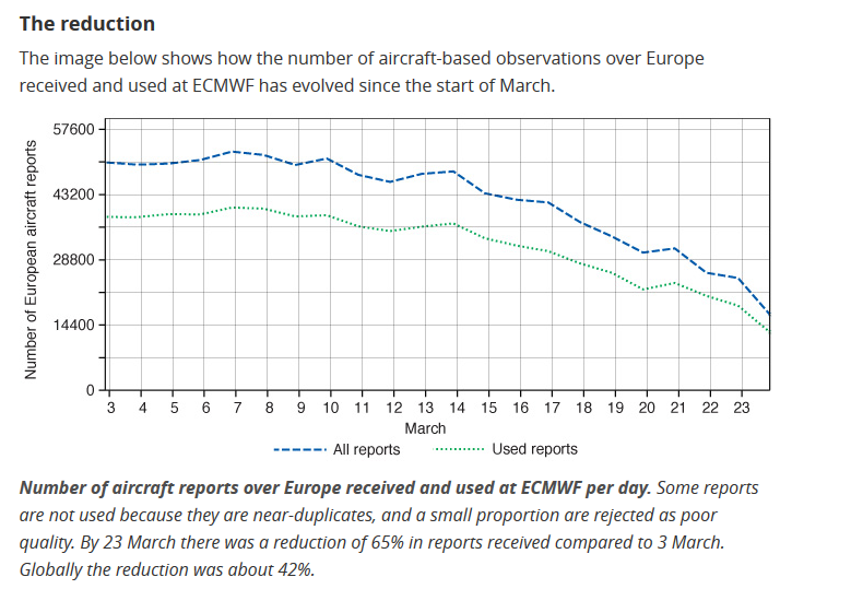
Due to the COVID_19 pandemic, the number of aircraft flights has fallen dramatically and so has the data coming in. These worldwide observations help to create a snapshot of what is actually happening at certain points in time on the surface and also at various heights in our atmosphere. There is also now a decrease in the number of surface-based observations as people’s movements and working is restricted.
So what impacts do different types of observations have on the forecast? Observations, such as those from the surface at weather stations and airports, marine observations from ships and buoys, radiosonde soundings upwards and radar. FSO, Forecast Sensitivity to Observations investigates these impacts and has done for aircraft data. In 2019, aircraft observations gave 13% impact of all observations at ECMWF. They have recently added satellite wind observations to help with any drop in data. The Met Office gave 8% of impact from aircraft data and in 2018 announced they were “the only National Met Service collecting aircraft based observations from commercial aircraft using its own network of receivers. “
For a long time observations have come from pilots then AIREPs of routine in-flight conditions and the hourly METAR from airfields. More recently there has been a WMO programme called AMDAR Aircraft Meteorological Data Relay. It takes in upper wind and temperatures data, increasing the accuracy of jet stream forecasts and aids higher precision and reliability for thunderstorms, icing and turbulence forecasting. This is remote data, which might not have been forecast at all. It validates the model outputs and adjusts satellite biases, whilst still advising pilots of significant weather and improves the accuracy of warnings.
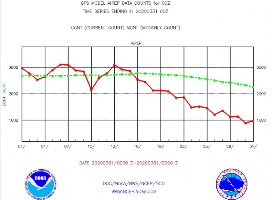
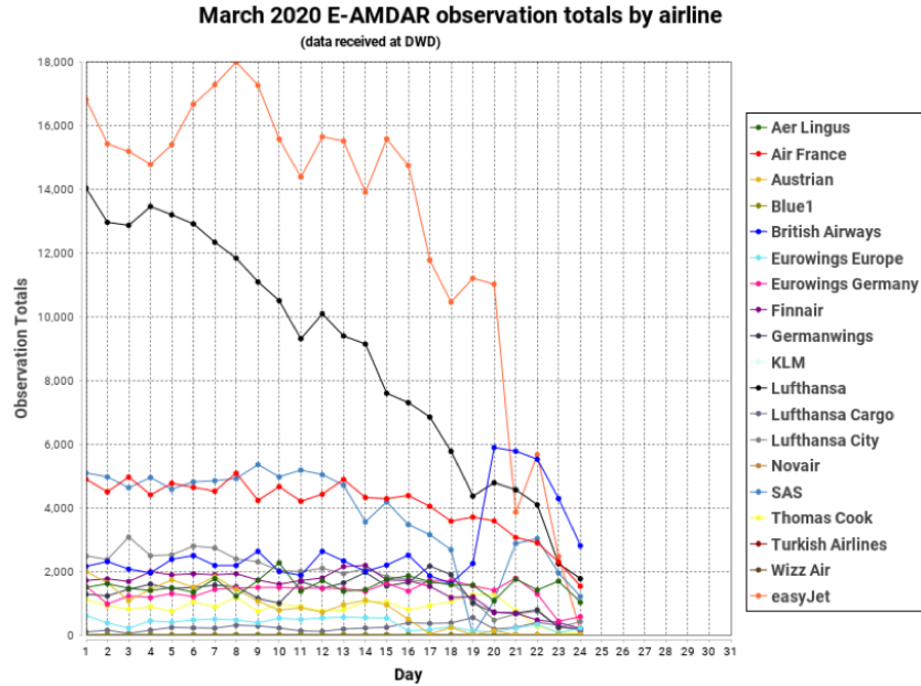
EUMETNET (a collaboration between the 31 national weather services in Europe ) co-ordinate the European aircraft reports and have been badly affected in recent weeks. “AMDAR coverage will be reduced by 65% or more …expected to continue into the summer” This observational data creates a starting point guess globally which with quality plentiful data can be a good start. With less data, more guesswork is needed to fill in the gaps.
As domestic flights continue over the US the effects have been less in an area that is traditionally dense in data. That will change. Data from other parts of the world area will continue to be affected in the coming weeks. Some cargo flights report but that is a much smaller proportion. “We are anticipating the substantial reduction in the availability of US AMDAR data to continue over the coming weeks, likely to generate some measure of impact on the output of our numerical weather prediction systems,” Christopher Hill National Oceanic and Atmospheric Administration (NOAA).
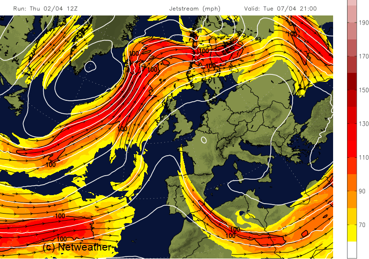
The AMDAR observing system “ uses onboard sensors, computers and communications systems to collect, process, format and transmit meteorological observations to ground stations via satellite or radio links. “ These are high resolutions measurements from the surface way up into the troposphere which is transmitted in real time. The largest impacts are centred around 250-200hPa, typical aeroplane cruising altitude, for wind and temperatures data. It is Jetstream measurements and modelling that are suffering.
"The current decrease in obs availability is as well impacting the monitoring of crop growth or flood risks, as these models now get less input data." E. Muller
Discussions are underway to boost the observation network. Finland, Germany and Switzerland are putting into place extra radiosonde launches.
And the Aeolus satellite will add a bit of wind data. Discrete weather events can affect the model performance anyway so no-one is keen to leap to conclusions about the impact of fewer aircraft obs too quickly.,
From ECMWF “ the number of aircraft observations has gone down significantly over the last couple of weeks both over Europe and globally. In the coming days and weeks, we expect a further decrease in numbers, which will have some impact on forecast quality in the short-range, particularly around the polar jet stream level (10–12 km altitude)."
"Sensitivity studies at ECMWF have shown that removing all aircraft data degrades the short-range wind and temperature forecasts at those levels by up to 15%, with significant degradations at all forecast ranges up to seven days. There is a smaller, but still statistically significant, impact on near-surface fields, up to 3% on surface pressure.”
For those saying, well it's not all bad, air quality has improved and aviation was contributing to about 3% of global CO2 anyway, the WMO respond “The economic and industrial slowdown as a result of #COVID19 is no substitute for long-term #ClimateAction to cut greenhouse gas emissions”
Loading recent activity...