Quite a change midweek as heavy and persistent rain sets in with warnings from the UK Met Office. Over 100mm of rain is possible for high ground with a risk of flooding and disruption
There is the risk of flooding and disruption as heavy and persistent rain sets in. The Met Office has issued an Amber warning for heavy rain for NW England and North Wales midweek. Working in conjunction with the Environment Agency, the warning runs from Wednesday 22nd afternoon overnight into Thursday 23rd morning and states:
“Rain will become heavy and persistent later Wednesday and Thursday with flooding and disruption likely.” “The heaviest rain is expected over north-facing hills and where strong winds enhance rainfall accumulations. Many places within the warning area will see 30-40mm of rain, with high ground of northwest England seeing 70-90 mm. Whilst mountains of north Wales may see 100-150mm or more.” MO
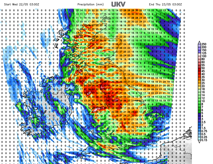 Forecast 24 hour rainfall totals from UKV model
This is an unusual setup with low pressure moving up the North Sea out of Europe with its rain bands rotating over Britain today. In the north-to-northwesterly flow down over Northern Ireland, then the Irish Sea, the moisture-laden air will encounter Eryri/Snowdonia and be forced upwards. Air rises from the sea up against the mountains of north Wales and orographic enhancement occurs. Heavier rainfall results and it will take time for that rain to flow back down to places like Colwyn Bay.
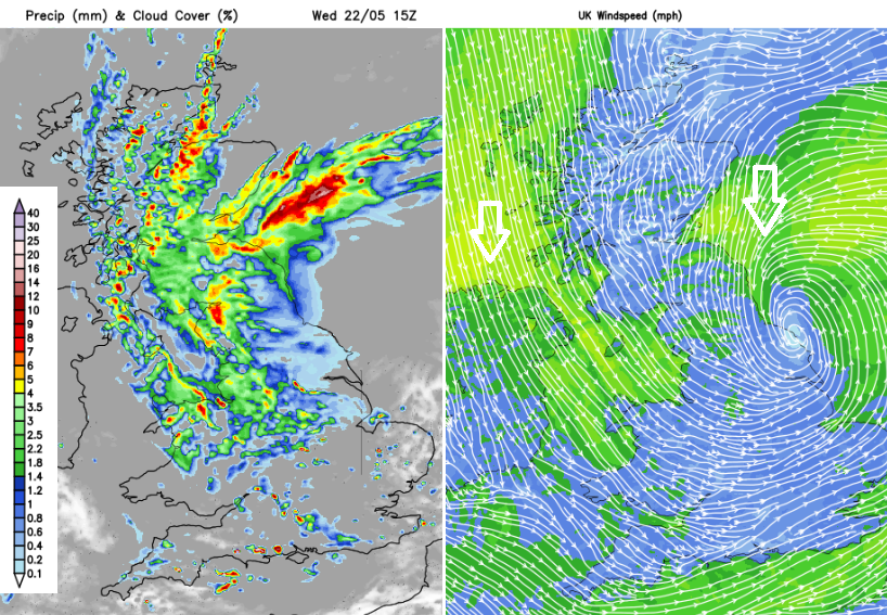 Higher rainfall totals for north-facing high ground
The moist flow persists through Wednesday, through the night and although it begins to ease off on Thursday morning these areas remain in a damp flow thanks to the northwesterly wind: North Wales including Anglesey, NW England the amber warning includes Cheshire, Manchester and Merseyside, just reaching the Peak District.
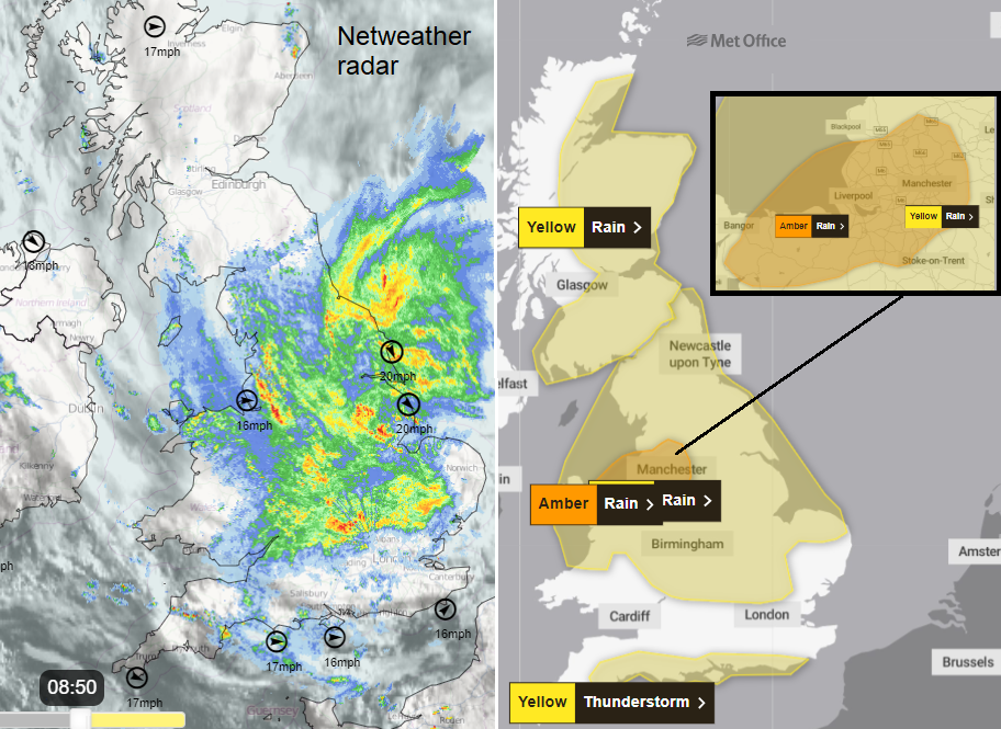 Netweather Radar showing rain before 9am and Met Office warnings for Heavy rain and Thunderstorms
The Amber warning relates to a Medium likelihood of Medium Impacts from heavy rain and covers more highly populated areas. There is a wider yellow Met Office warning for heavy rain over a central swathe of Britain. This also mentions north-facing hills with some uncertainty about which areas will see the heaviest rain. You will know your local conditions and tricky places that quickly respond or flood in heavy and persistent rain. It is harder for visitors and holidaymakers. The Yellow warning indicates a Low likelihood but still of Medium impacts.
There are flood alerts for the Midlands and ongoing groundwater concerns for central southern England with alerts from the Environment Agency here too.
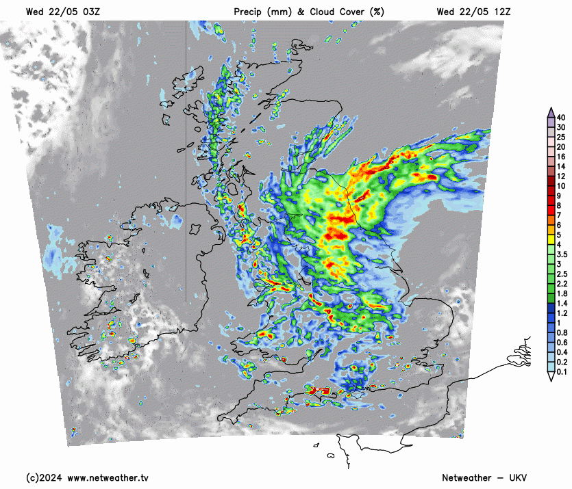
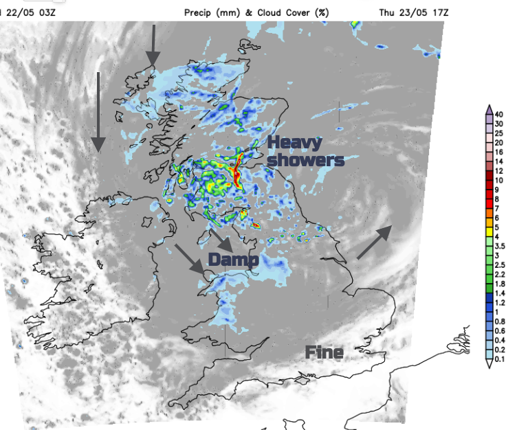
The main area of rain for Wednesday will drift northwards, covering more of northern England but leaving East Anglia brighter and perhaps around the Humber by this afternoon. There is uncertainty here about how far westwards the main rain will tip, which could leave the Humber up to the Tyne, claggy and damp all day or some brighter lee gaps may develop for eastern England in the afternoon. Overall the flow looks cloudy and damp into SE Scotland as the heaviest rain continues over the Pennines and northwest and north Wales. It should turn more showery for mid-Wales and the Midlands by late afternoon.
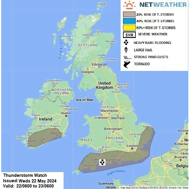
There is a different warning for southern counties of England, for thunderstorms. “Scattered showers and thunderstorms may lead to some disruption.”MO. The Netweather convective forecast for Wednesday 22nd
"instability and breeze convergence could trigger some heavy showers and thunderstorms late morning and through the afternoon. However, this is dependent on southern extent of cloud cover / extensive rainfall covering much of England, so only delineating a 20% risk of a thunderstorm at this time, given uncertainties of sufficient cloud breaks/surface heating. "
A line of heavy showers is forecast from SE Ireland across Pembrokeshire to Devon and Bournemouth and although many places in southern England will stay dry there is the risk of heavy downpours or thunderstorms today. The risk of a downpour extends over southern Britain by this afternoon with parts of London and the Home Counties looking more likely to catch a shower by this evening.
Scotland starts the day mostly dry but cloudy, there are a few isolated showers. Heavy showers will break out along the west coast as the main rainbands rotate north and westwards off the North Sea. It looks pretty miserable by this evening around Aberdeen with the heavier rain reaching Shetland tonight. The north winds will pick up as the rain continues to tip westwards which could give drier weather to the lee (the south) of the Grampians).
Northern Ireland looks to escape most of the wet weather today with just a few showery bits brushing the east coast this afternoon Country Antrim will turn wet later this evening and overnight with driving rain thanks to the cool north wind.
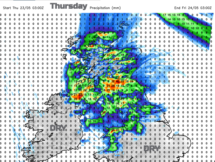 24 Hour rainfall totals for Thursday UKV
Thursday
The rain will be easing off with a dry start for much of southern Britain, bright in the southeast. Areas exposed to the blustery winds will continue to be cloudy and wet, adding continuously to the rainfall totals as Wednesday’s heavy rain flows down off the hills. It is the stationary nature of this low pressure which will cause problems with persistent rainfall. The rain might be welcomed by some after the lengthy settled dry spell, for those who missed the thundery showers.
There is a signal on the UKV model for heavy downpours to develop through the Central Belt of Scotland and the far north of England during Thursday afternoon and evening. So those will add to any surface water and bring further tricky conditions on the roads.
As we head into the Bank Holiday weekend we leave this very wet spell behind.