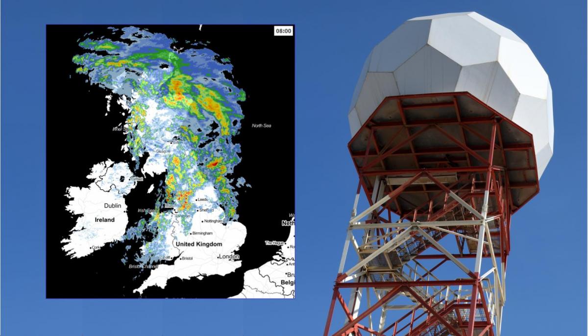
How does the rain radar work? There is a network of radar stations across the UK and Ireland scanning the skies and outputting images showing rain, snow and thunderstorms helping the weather forecast.
Across the UK and Ireland is a network of radar stations, gathering data about our rainfall and assisting the weather forecast with vivid, familiar output. Where it is raining, who's got a wet day, a scattering of heavy showers, thunderstorms, snow, hail or how fast a front is moving across the UK. Radar pictures are amazing and easily available but sometimes it's not quite as straight forward to interpret them as you might think.
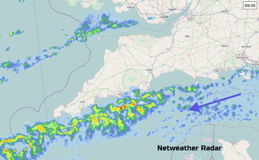
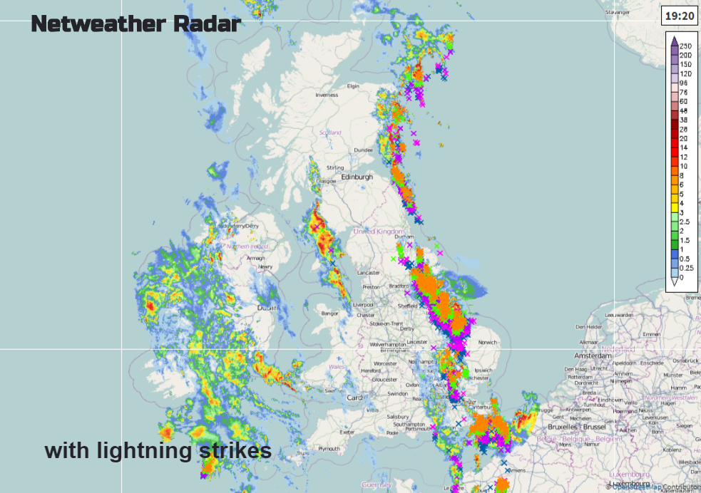
Weather observation data is vital and comes from many sources. From the sky, weather satellites above us with increasingly clearer, more regular images from around the earth. From observers taking hourly, daily, weekly even monthly readings, or automatic stations sending in their data constantly (IT allowing). There are observations from ships and buoys and from weather balloon sondes. Another key weather feed is Radar. RAdio Detection And Ranging, the images you see on television broadcasts, our own Netweather Radar, or on your mobile phone. These are images of current rainfall, not a forecast but what is actually happening outside.
In the UK. these pictures are invaluable for nowcasting if a heavy shower is on its way, watching frontal rain heading in from the Atlantic or summer thunderstorms marching north. It can be used to verify how the model is doing in its early frames, is the rain in the right place? Watching the progress of thunderstorms or how they are developing in situ on a summers afternoon, is there a risk of flash flooding? And as initial actual data, it can be fed into the forecast models. If this is clearer, more detailed and there is wide coverage then it will aid the whole forecast process. Radar gives the location and intensity of precipitation, rain, hail and snow in real time.
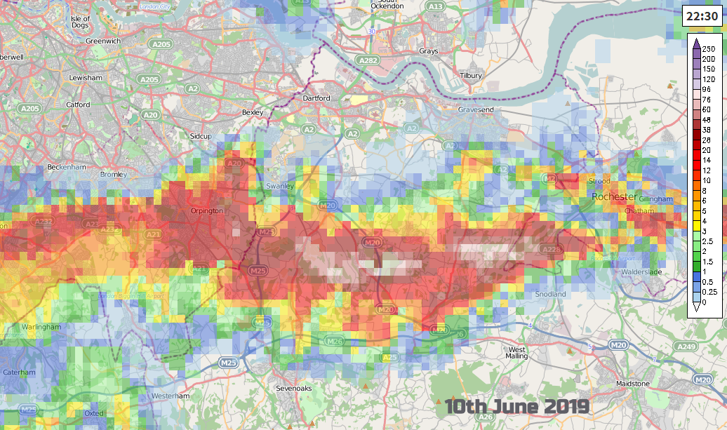
Along with the rain gauge network, the radar data is invaluable for flood forecasting. Image above Netweather July 2017
With all this in mind, the Radar network across the British Isles has been upgraded in recent years. The stations are land-based and cover 99% of the UK, (nothing for Shetland) and there is coverage for Ireland and the Channel Islands. There are 18 weather radars; 15 looked after by the UK Met Office, two in Ireland and one on Jersey. They each provide data out to 250km and have a five minute scan period.

The radar site has a tall structure with a radome around the actual radar as a protective cover. This will protect the radar from strong winds and hail. Currently, in Cumbria, there is a portable temporary radar gathering extra data. This doesn’t have a cover and so has wind restrictions on its operation. The permanent radar stations are designed to be more robust. As low pressures come in from the Atlantic there can be strong winds with the heavy rain. However, calmer waving fronts can result in tremendous rainfall totals as can thunderstorms.
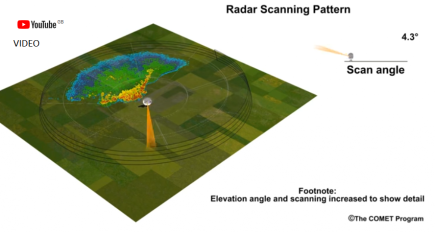
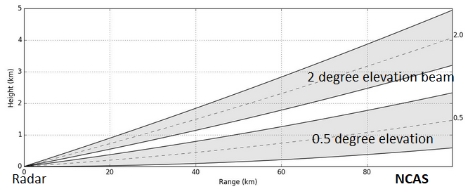
Elevation
The radar dish has a diameter of 3.7m. A radar beam is sent out, around the circle and gradually round at different elevations and then the radar station listens for the return echoes. This takes most of the time period. The pulse has a specific wavelength of 5.6cm. It comes back as reflectivity, a tiny bit of the radar signal is reflected back off the precipitation and recorded. The resulting data is then sent for processing. The time and strength of the signal give its location and intensity. The resulting picture isn’t always straightforward, there are a few nuances to interpreting radar images but the Met office sort a few things and then issue a composite picture of rainfall rates.
After the upgrade, as the resolution improves, we can see clearer images of showers, thunderstorms and frontal bands. Analysis of the data can look at growth rates of flash flooding events which can then be used to review emergency responses and help water authorities and the environment agencies prepare and plan.
What is good about Radar?
It covers most of the UK, near real-time, about 5 minute lag, improving resolution. Images 24/7 every five minutes. Comparison to rain gauge data to check and improve output, ground-truthing with Environment agencies. It is easy to see what is happening most of the time. Recent upgrades have improved precipitation type information. For tornado warning areas like the US, radar is invaluable to issue warnings and save lives.
Issues with radar imagery
Clutter – It is not only precipitation which will reflect back the radar beam. All sorts of stuff gets in the way. Occultation - an event that occurs when one object is hidden by another object that passes between it and the observer. When an object in the foreground blocks from view (occults) an object in the background.
Permanent echoes – Hills, buildings or surface obstacles can block the radar beam, and are referred to as clutter. Some of these obstacles can be dealt with as they are always in the same place and so there is a base image to clear out. A network of overlapping radars can help to minimise this problem but the Dublin radar has been plagued by issues for years in a built-up area. Wind turbines or certain trees cause problems which are quite distinct at times. Usually, a site is chosen to avoid most interruptions but with land use restrictions and overall distribution, choice is not always wide and hilly Cumbria still needs monitoring.
Spurious echoes – Birds and insects are the most interesting ones. Sea waves and military exercises in the Channel with chaff also causes echoes too. They come and go, it’s worth just questioning the image first if something odd appears. Dual polarisation will help remove more spurious echoes in the future.
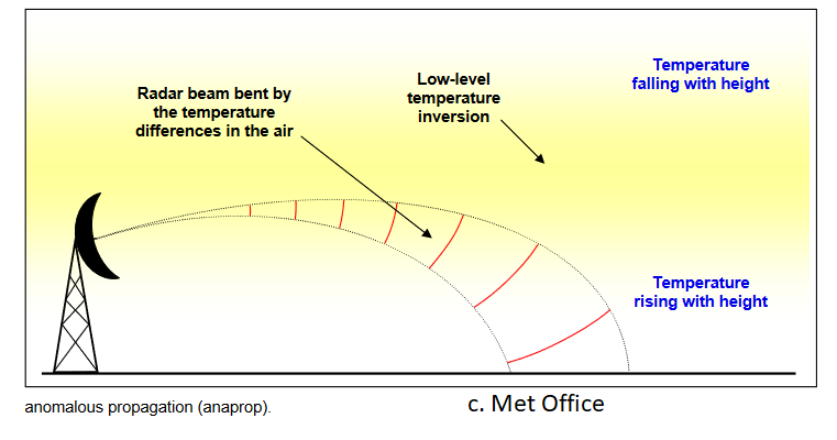
AnaProp (AP) Anomalous propagation “Radar beams are like light beams, in that they travel in straight lines through a uniform medium but will be bent (refracted) when passing through air of varying density.”
In the UK it is usually a low-level temperature inversion that results in AnaProp being seen (temperatures increase with height, often early in the morning in still conditions when surface is cooler) the radar beam is bent downwards and strong echoes are returned from the ground. Americans call it ducting. This usually occurs in anticyclones and so strong signals do stand out quite easily as being false. It can be seasonal in its appearance too. .”
Bright Banding- Radar echoes from both raindrops, hail and snowflakes are calibrated to give correct intensities on the rainfall display. In rain/snow events where the temperature is near 0°C, melting merging snowflakes which have large, wet, reflective surfaces, give strong echoes as they collapse into raindrops. These produce a false band of heavier rain, or bright band, on the radar picture. It looks odd so knowing about Bright Banding is useful, you have to remember winter to winter though.
AMS “The bright band is observed primarily in stratiform precipitation. The strong convective currents in active showers and thunderstorms tend to destroy the horizontal stratification essential for creating and sustaining the bright band.”
The positioning of the radar station is important but also the height of the dish. It helps if the beam is not obstructed by objects but if it is too high it might be above the freezing level in winter and report ice or snow when closer to the ground there is only rain.
Sometimes people moan that it’s raining where they are but it’s not showing on the radar, or the other way round. Rainfall radar output does need some understanding. There are also observations on the ground about cloud heights and present/past weather, webcams and rain gauges to assist and give extra information. Do remember that rainfall at the surface may vary from what you are seeing on the radar output. Processing can help with some of the issues but not everything.
Drizzle – The radar can cope well with rain, snow and hail but drizzle droplets are generally too small to be observed reliably. It can be missed unless it is falling close to the radar as it comes from low-level clouds.
Improvements - There has been new technology available for a while, it was just a case of finances and time before the UK upgrade took place. New hardware and software have been introduced with various radar stations being out of action for a few months, at different times. The doppler was installed first and then the dual polarisation radome and new tower infrastructure. Some of these sites were quite remote or exposed and the local weather didn’t always help the time scales.
Doppler - Doppler radar gives extra information about how the precipitation is moving. It still detects the intensity of the rain but also speed in a particular direction from the radar station. Full Doppler capability is now in place across the UK.
'The radar transmits pulses of radio waves, rather than just one beam, then keeps track of the phase (shape, position, and form) of those pulses. By measuring the shift (or change) in phase between a transmitted pulse and a received echo, the target's movement directly toward or away from the radar is calculated. This then provides a velocity along the direction the radar is pointing, called radial velocity. A positive phase shift implies motion toward the radar and a negative shift indicates motion away from the radar.' NWS
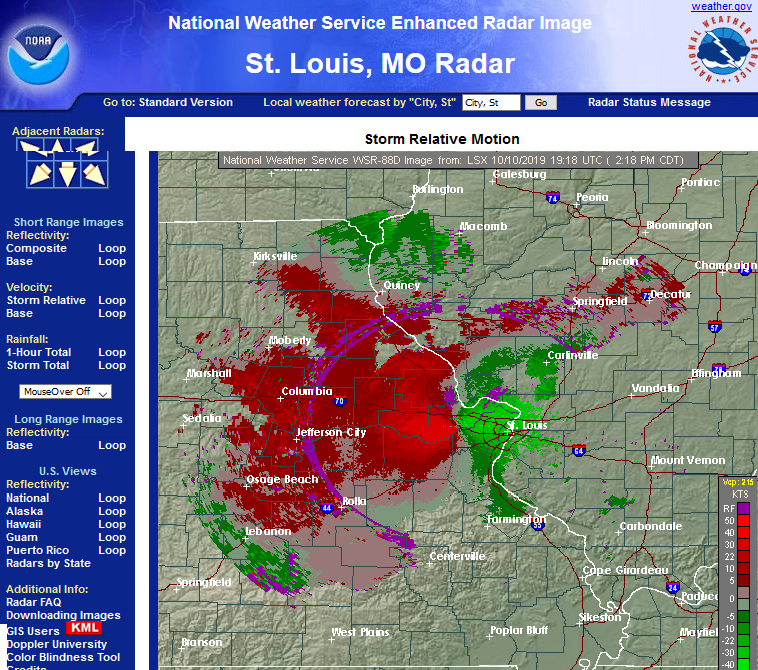
This has been used by storm chasers and the National Weather Service in the US for tornado warnings. It can identify rotation, with different colours showing motion towards and away, often red outbound wind and green inbound. We don't get to see the doppler output but the information will feed into the forecasts and warning procedures with other agencies.
Dual Polarisation - Dual Pol
.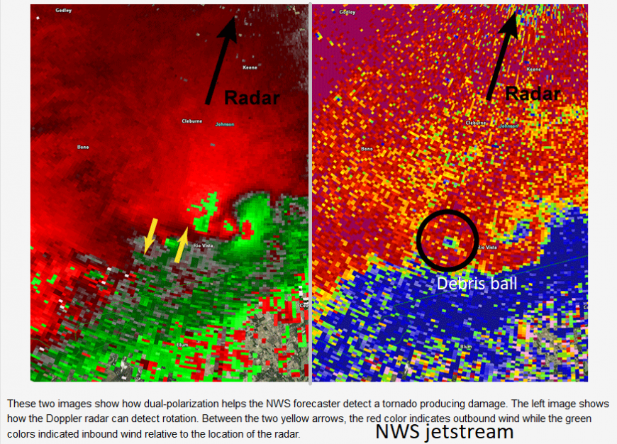
For tornado detection, doppler would have shown rotation but at night or in remote areas, before dual-polarisation, there wasn't a sure way to say that a tornado formed. As Dual-Pol can detect tornadic debris- here a debris ball, so it can provide additional confirmation of tornadoes occurring. Are more being reported?
The UK network can now recognise the size and shape of raindrops and snowflakes. One part of the upgrade was to include dual polarisation measurements. This allows types of precipitation to be identified; rain, hail, snow and ice crystals.
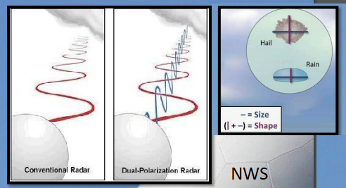
“New software and hardware attachments will be integrated with each radar dish so that both vertical and horizontal radio pulses will be transmitted and received. The radar station will analyse the amplitude and phase properties of return signals, from both the horizontal and vertical channels, to determine the shape, density and speed at which the precipitation is falling. The dual polarisation design is switchable between single linear transmission and simultaneous horizontal and vertical transmission” Met Office
So it can go back to the old single way or do it's flat & upright combination of signals. It is also helpful with non-meteorological echoes, as discussed in the clutter section, Dual Pol can help clear out or distinguish unwanted echoes. It can also help with more accurate accumulation rates. When used alongside the rain gauge network, merging radar precipitation rates and accumulations improves the output.
Expanding the Network
Over decades new sites have been added and there is good coverage across the UK now but there are still some areas that could be improved. Two ongoing projects address gaps in eastern England and NW England but in different ways. For East Anglia a new permanent is planned, in Cumbria, a temporary portable radar is in use this year with an eye to more long term future plans.
East Anglia
An additional radar station for East Anglia. After a review, this was recommended to improve the overall network coverage and provide better observations from the North Sea. After the Beast from the East more observations for eastern England were required looking at heavy showers and particularly snowfall.
It wasn’t just about winter setups but also convective storms in the summer and slow-moving systems, both of which could bring high impacts to the region
East Anglia can be one of the driest parts of the UK so any improved rainfall data would be useful in managing water resources and emergency responses. Across the network if there is good data, the forecasts improve so the warnings are more useful, councils and services can prepare, people can adjust their behaviour, they stay safe and insurance claims are lower. Rainfall data is used by sewage systems companies and farmers always want information about water supplies, for planting, treating or harvesting. There is also Norwich airport and two RAF bases nearby.
The proposed site at Old Buckenham is about 30km SW of Norwich and will extend the coverage nicely out over the North Sea. It is currently going through the planning process with a public meeting throwing up some interesting concerns. About why it had to be so tall – it needs to exceed the tree line so there isn’t interference. Will there be any noise? – there is some sound but it should be minimal. Will the radar affect TV, radio or Wi-Fi? – No, the weather radar operates within a narrow frequency band. The Met Office has to apply to OFCOM for a license to use a specific frequency in a location.
Current plans would see work starting in 2020 but take several months. For a new permanent fixture, a lot of time, planning and budgeting is needed, even if a suitable site is identified.
Cumbria XBand
On the other side of Britain, there is room for improvement with the level of radar detail provided over Cumbria. This region has seen significant recent flooding episodes, including Storm Desmond, but is poorly observed by the national radar network.
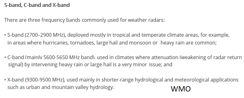
The Met Office in collaboration with the Environment Agency has put a NCAS mobile X-band radar in place, for a year, to gather extra data. It is a fancy bit of kit from Hampshire which has visited the Cape Verde Islands and NE Scotland. It is portable, smaller and can be used to gather information for a business case, say a more permanent radar facility. It can be transported but does have some restrictions on its use, a temperature range of -10 to +35C and winds of up 56mph. X-band is a secondary banding for radar, with S and C bands being used and kept for meteorological purposes.
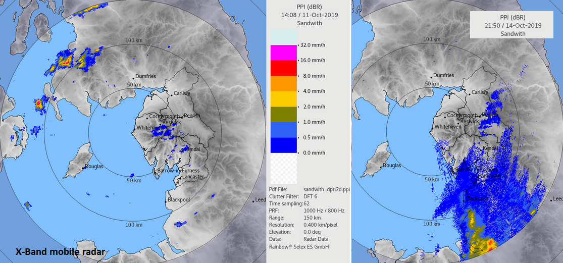
It is hoped that the extra information will improve flood forecasting in the UK. The rainfall output is not being fed into the radar picture, it is just for research this year. I asked the various agencies about their plans. (Met Office/Env.Agency/NCAS)
You have a temporary portable rain radar installed in Cumbria, can you tell us more? Is there a gap and what do you hope the portable radar will do? "The quality of the coverage over part of North Cumbria could be better and we (the Environment Agency and Met Office) are looking into the feasibility of investing in a permanent radar in North Cumbria.”
"The other objectives of the temporary radar are that in real-time it does provide an additional source of information during heavy rain incidents so will help to manage the flood response. After the 12 months the data collected will be used for a number of academic studies – in particular, to help improve our understanding of the extent to which rainfall is orographically enhanced – which is an issue that regularly affects the uplands of Cumbria. "
Does Cumbria's topography pose any particular problems to radar and rain gauge network? "The remoteness of some sites does pose communication issues for automatic collection of data but new technologies are helping to resolve this and we are investing in new technologies to improve the timeliness and resilience of data collection."
With climate change and expected heavier rainfall events, what adaptation and future-proofing is going on? "Last year the Met Office completed an £11m upgrade programme. All 15 UK radars were upgraded over 6 years to improve their reliability and to exploit new doppler and dual-polarisation technology. The resolution and accuracy of rain measurement have been significantly enhanced which will future proof the network as the climate changes."
What will happen to the portable radar after its year posting in Cumbria? "It will return to NCAS Hampshire before being prepared for its next project in Indonesia."
In order to create the radar images that you view on your phone or PC, for rainfall data to be used as initial observations in Numerical Weather Prediction or warnings there is this growing, improved network of radar stations around the British Isles. The radar images are great for weather information, to see if it is going to rain on your way to the bus stop or on your washing but they do need a bit of understanding to be really helpful.
Loading recent activity...