The Bahamas evacuates as Florida watches Hurricane Dorian even with uncertainty in the forecast. Spaghetti plots show plenty of variation and will there be any influence on our UK weather?
"DORIAN FORECAST TO STRENGTHEN INTO A MAJOR HURRICANE DURING THE NEXT COUPLE OF DAYS. " NHC
The Atlantic hurricane season had been rather quiet with just Hurricane Barry back in July bringing storm damage and terrible flooding for Louisiana. Now there is Hurricane Dorian which looks likely to hit Florida early next week, so at the start of September.
The governor of Florida has already “declared a state of emergency to ensure local governments and emergency management agencies have ample time, resources and flexibility to get prepared. “
Previously Dorian had moved near to Barbados, St Lucia, St Vincent, Martinique and the Grenadines as a Tropical Storm. Then Puerto Rico had a hurricane watch, but the warning ended up being slightly further east over the Virgin Islands where there was heavy rain, wild winds and a large swell.

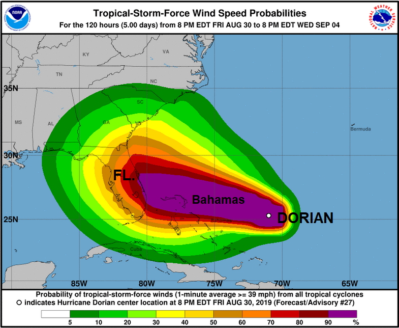
Interests in the north-western and central Bahamas should monitor the progress of Dorian.
"Expected hazards include the central Bahamas...2 to 4 inches, isolated 6 inches. The north-western Bahamas and coastal sections of the southeast United States...4 to 8 inches, isolated 12 inches. This rainfall may cause life-threatening flash floods." NHC
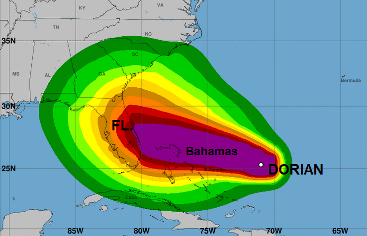
Currently Dorian is out at sea and forecast to curve NW right towards Florida. This is still several days away so it’s worth looking at the full cone graphic, not just the central path. However, if you are heading to Disney World next week it might be worth keeping uptodate with the forecast.
Heavy rains and flood risk are being highlighted for parts of the Bahamas, Florida and other areas in SE US. There are variations, as always, with the different weather models.
"The GFS is a northern outlier from the rest of the guidance, showing a weaker ridge and bringing Dorian close to the Florida/Georgia border, while the UKMET and ECMWF models show stronger ridges and remain the southernmost solutions near South Florida. Given the spread in the guidance, the new NHC forecast blends the previous forecast with the simple multi-model consensus aids and the HCCA and Florida State Super Ensemble aids, and it actually ends up in a position very close to the tightly clustered global model ensemble means. The most notable change in the new forecast is that it's a little bit slower than the previous one as Dorian approaches Florida."
This is from the National Hurricane Centre (NHC) Discussion, but it is part of the Key Messages too, that people should not get caught up on a specific path and that storm force winds could affect Florida by Saturday night, the Bahamas earlier. The ECMWF shows Dorian over New Providence, the most populous island in The Bahamas, containing more than 70% of the total population.
What will it do after that? Well, it’s tricky to say as we don’t know if it will head west across Florida. If it does it could end up in the Gulf of Mexico or just pull north over the southern States bringing heavy rain and extensive flooding. It could curve up the eastern seaboard, hit a different part of the US, or just stay out at sea. The forecasts charts are about likelihood and risk.
You may see lots of paths on a graphic that looks like a plate of Spaghetti. These aren’t useful if you are worried about your actual house or school on Monday at 11am but these help forecasters look at a bigger picture.
As people in Florida and the Bahamas make preparations: getting extra food and water, looking at escape routes and potential adjustments to their Labor Weekend plans there is a new app to report "Price Gouging". Where stores vastly inflate prices of key items under panic buying in a state of emergency. The airlines are being called out for their part in this, although not covered on the app.
People in the UK are always keen to know if these hurricanes will affect our weather in the end. No answer on that currently for Dorian. Further north there is Erin, which was a tropical storm and now has moved over cooler waters and changed to a post-tropical cyclone, a different type of low pressure.
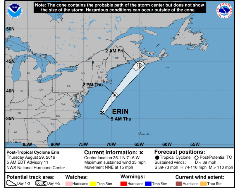
This one is forecast to head north near to Newfoundland and then curve east. As what was Erin moves across the north Atlantic, it’s once tropical remnants will change and mix with other systems and that extra bit of energy could bring a bit of oomph to a low pressure moving north of the UK early next week. Our UK forecast is becoming fresher and more blustery for the end of the week anyway and the start of September.
The Atlantic hurricane season traditionally runs from 1st June to 30th November. More discussion and chat about Hurricane Dorian in the Netweather Forum.
Loading recent activity...