This blog will look at the potential impacts of the ongoing Sudden Stratopsheric Warming (SSW) which looks to split the stratospheric polar vortex and also other global atmospheric drivers which will likely impact weather patterns affecting the UK as we head through the rest of meteorological winter, increasing the risk of colder and wintry weather.
The Stratospheric Polar Vortex is an area of low pressure or vortex high up in the atmosphere that usually sits over the Arctic (with an equivalent over the Antarctic) and features strong west-to-east winds circulating around it encircling the north pole. These strong winds are known as the “polar night jet” because they appear in long darkness of an arctic winter. The polar night jet forms the boundary between very cold arctic air wrapped up in the polar vortex and warmer further south over mid-latitudes.
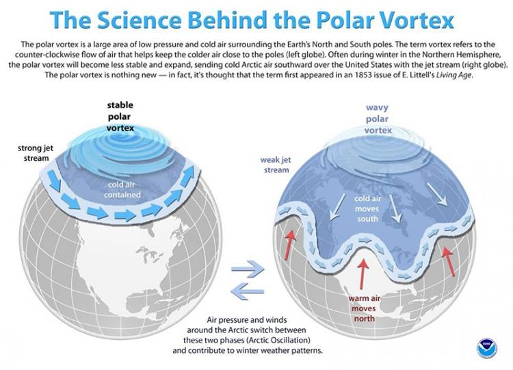
When a Sudden Stratospheric Warming (SSW) occurs the usual westerly flow over the arctic is disrupted by poleward waves (usually ridges of high pressure moving up into the arctic) emanating from the lower latitudes in the lower atmosphere. This causes wobbles in the polar night jet which cause wave breaking that weakens the polar vortex and can reverse the winds from westerly to easterly – causing a warming in the stratosphere as the air in the stratosphere collapses and compresses. The term SSW refers to a rapid warming (up to about 50 °C in just a couple of days) in the polar stratosphere, between 10 km and 50 km up.
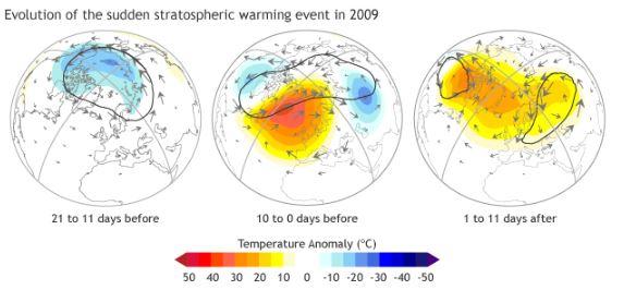 Evolution of SSW in January 2015. Image courtesy of Patrick Martineau
Eventually the easterlies winds in the stratosphere move down to the troposphere - the lowest part of the atmosphere where our weather is, though it can take up to a few weeks for this process to take place. These easterly winds moving down into the troposphere tend to alter the pressure patterns in the mid-latitudes by leading to blocking areas of high pressure at higher latitudes such as Canada, Greenland and Scandinavia which block the usual mild westerly flow across USA and Europe including the UK and dragging in cold polar air from the north or cold continental air from Russia or eastern Europe in the case of the UK.
However, the Stratospheric Polar Vortex is often confused or mis-represented by a second polar vortex seen lower down in the troposphere – where our day to day weather occurs. This has created a plethora of mis-informed weather stories in the media such as today’s Mirror story of “Triple polar vortex bringing SNOW and brutal -10C freeze”.
The triple stratospheric polar vortices have been modelled but may not directly affect the weather near the surface for perhaps up to 2 weeks & there is no credible link, at the moment, for them bringing snow & brutal -10C freeze as suggested above. The article also uses a Netweather snow chart used stamped 17/01 - which is as useful as a chocolate teapot at that range!
Other stories include the Independent’s “New Beast from The East could bring snow and freezing temperatures to the UK in January” and although the article does refer to the SSW possible being the cause it does at least say that a SSW does not always lead to cold snowy weather. Indeed statistics suggest that around 70% of SSWs lead to cold and wintry weather for the UK, so although more often than not they do, it’s too early for media headlines or anyone to state with any conviction that the polar vortex or beast from the east will bring cold and snow.
The weather models have been predicting a SSW around the start of 2019 for a while, GFS probably way back in early December, some longer range seasonal models perhaps before this even. The SSW or wind reversal from westerly to easterly at 10 hPa / 60N occured on the 1st January 2019.
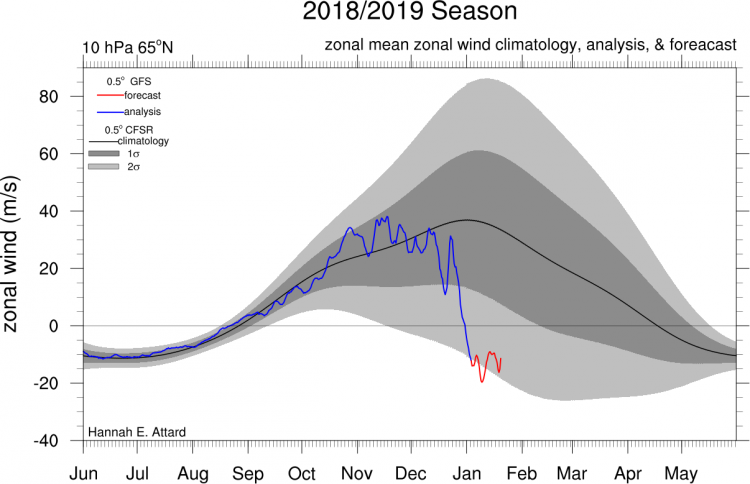
Image courtesy of Hannah Attard
The SSW splits the stratospheric polar vortex, either into two or even three 'daughter' vortices
It is not just the SSW and polar vortex split that may lead to a cold spell with risk of snow as we head through the rest of the month. There are other global drivers of our weather that can lead to colder and wintry weather for us.
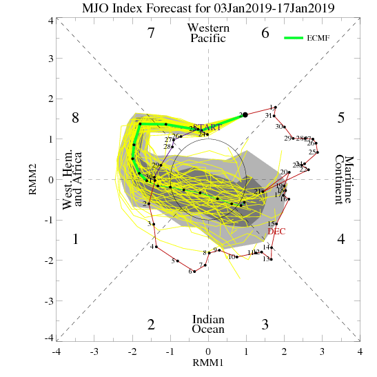
The Madden Julian Oscillation, which is an area of active and enhanced tropical convection moving over the tropics of Indian and Pacific ocean, can effect the weather patterns of N America and Europe. There are 8 phases of the MJO and phases 7-8-1 are when it most moves over the tropical Pacific and tends to lead to poleward wave propagation which can have an impact on the polar vortex and also can lead to a negative North Atlantic Oscillation – which is an indicator of blocking high pressure over Iceland / Greenland and low pressure over SW Europe or Azores associated with cold and wintry weather over northern Europe. The current model MJO forecasts take it through phase 7 and 8 over the coming week or so, so the lag of one to two weeks is likely to have an impact on the upper patterns over mid-latitudes and increase the likelihood of increasing the risk of colder weather for the UK by mid-month – this perhaps before the likely impacts of the SSW / wind reversal moving down from the stratosphere and imprinting on the weather patterns too.
Also, there is the current weak El Nino, El Nino tends to favour colder weather later in winter. More directly, Global Mountain Torque events are also responsible for changes in the upper flow patterns that bring our weather. These mountain torque events are synoptic-scale wave trains that disperse energy across Asian and North American topography. Currently there is a significant East Asian Mountain Torque (EAMT) event – this may lead to an increase in the amplification of the upper flow over the northern hemisphere over coming days and increase the chance of blocking high pressure areas. These mountain torque anomalies can be attributed to an increase in Atmospheric Angular Momentum (AAM) - which is a measure of how fast the atmosphere is spinning relative to the Earth's rotation and is a complex variable that can offer insight to particular flow configurations within the atmosphere that ultimately affect the changing patterns that bring our weather. The mountain torques induced by the MJO circulation, explained above, are responsible for the angular momentum exchange between the atmosphere and the solid earth. As convection moves to the west Pacific, as indicated by the MJO forecasts in coming days, positive mountain torques from east Asian topography, as highlighted by the EAMT event above, provide for a continued increase in AAM.
So the MJO wave moving into phases (7-8) together positive EAMT and AAM anomalies over coming days are likely to be involved in forcing flow amplification and increased chance of high-latitude blocking over the coming few weeks. Current model guidance has hinted as some wave amplification next week, with high pressure close to / just west of the UK building north in wake of a low passing east to the north Scotland early in the week. GFS, UKMO and ECMWF both indicating a northerly developing next Wednesday, then possibly switching to a northeasterly flow breifly from Thursday as the high tries to ridge northeast towards Scandinavia. Cold air moving south, not particularly deep cold shown at the moment, but cold enough to produce daytime temperatures in low single digits and showers of a wintry nature in the north and east, perhaps snow over northen hills.
No sign of significant snow or severe cold yet. We may have to wait until after mid-month, maybe late January, until the SSW and polar vortex split occurring now, along with lag effects of the MJO into 'colder' phases and other drivers such as mountain torque / AAM impact the weather patterns to bring greater chance of high latitude blocking and a chance of more severe wintry weather. But no guarantees of this happening, but a greater chance of it than if there were no SSW. If the current warming and easterly winds in the stratosphere do couple with the troposphere, where our weather is, then the resultant pattern change (to colder) could last the rest of winter.
Loading recent activity...