


The weather is mixed this weekend, with Storm Helene lying in wait and forecast to arrive early next week.
It's not unusual for tropical storm remnants to affect the British Isles in the autumn, that often pass largely un-noticed as vigorous Atlantic storms. Ex hurricane 'Helene' is currently one of four tropical storms in the North Atlantic and due to pass to the West of our shores early next week, with its track uncertain at present.
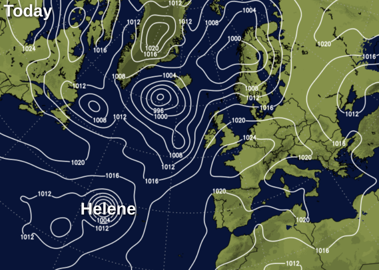
What it will do though, is 'pump up' tropical air, lifting temperatures into the mid-twenties by Tuesday over the South and East, giving wet and windy weather elsewhere. For the meantime, conditions remain much the same, with Atlantic systems affecting mostly the North and West.
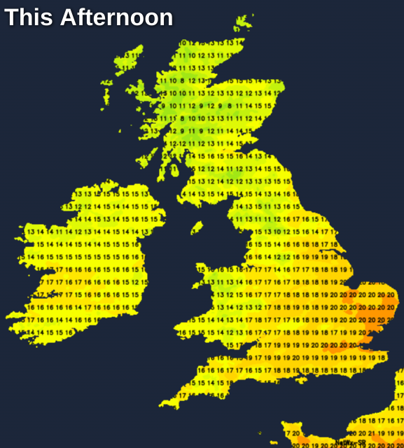
Across Scotland, the brightest weather this morning is towards Caithness and Moray, where some sheltered rural glens were cold enough first thing for a touch of grass frost. Eastern and some central parts of Scotland will be mostly dry and fine for much of the day with some sunshine for a while, but through the afternoon there'll be increasing cloud. Showers across Dumfries will fade for a time before outbreaks of rain move into many western areas later as a South or South West wind begins to freshen. Top temperature 12 to 14C in the North and West, but 16 or 17C towards The Borders.
Derry and parts of Antrim also have some rain at present, with much of Northern Ireland turning wet later, as Atlantic systems move in on a freshening southerly wind. A weak front is giving some patchy rain over parts of northern England as well, but this should slowly clear to the North, with Yorkshire, the North Midlands and Lincolnshire, in particular, seeing some warm sunny intervals coming through. Apart from a few light showers in the West, remaining parts of England and Wales will be mainly dry with variable cloud. There'll be some sunshine especially over East Anglia and the South East, where it'll become pleasantly warm by the afternoon as temperatures reach 17 to 19C generally and 21 or 22C towards the South East. A light or moderate South West wind will freshen in the West.
A southerly wind continues to freshen into the evening, becoming strong to gale in exposed parts of the North and West after dark. Northern Ireland and Scotland turn wet overnight, with heavy rain in places. North West England, Wales and the South West may also see showers later in the night, with patchy rain perhaps moving into the remainder of northern England and the North and West Midlands by morning. Towards East Anglia and the South East, it'll stay dry with clear intervals in a somewhat lighter southerly breeze. It'll be a mild night generally, with lowest temperatures mostly between 8 and 13C.
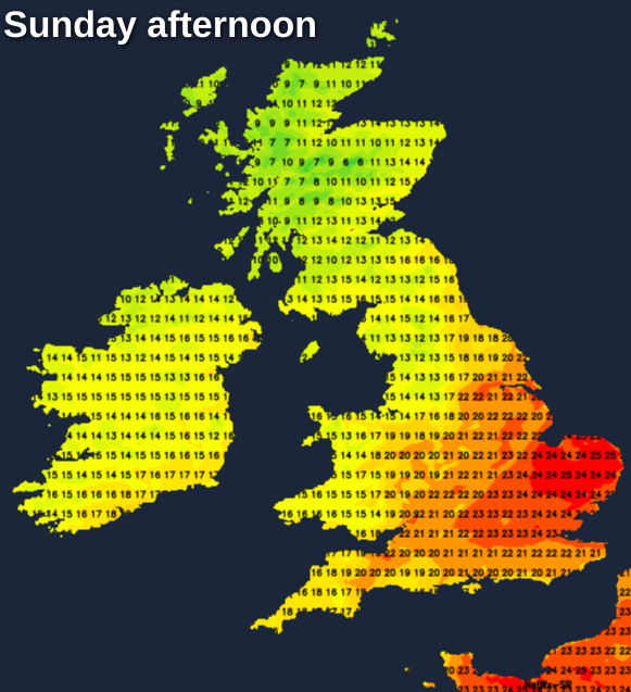
Sunday sees rain at first across Scotland and Northern Ireland, some of it heavy. This'll quickly clear from Northern Ireland and from Scotland through the morning, leaving sunny intervals and blustery showers most frequent in the North and West. Through the afternoon though, they should begin to fade from Northern Ireland and southern Scotland, as a fresh even strong at first West to South Westerly wind decreases. A trailing cold front will also give some rain across Northern England, Wales, the South West and parts of the Midlands where it'll be mostly light and patchy, with the brightest, driest warmest, weather again towards East Anglia the South East.
A South West to southerly wind will be lighter over England and Wales with top temperatures mostly 17 to 20C, but where the sun comes through and across the South East in particular, a warm 22 or 23C is possible. It'll be cooler and fresher over Scotland and Northern Ireland though, with highest temperatures here 12 to 15C in the North and West and 16 to 18C towards Lothian and The Borders.
Further bursts of rain may continue to affect Wales, northern England and South East Scotland after dark, while much of Northern Ireland and remaining parts of Scotland should be clearer with just a few showers in the North and West. The Midlands, South West and central southern England could also see patchy rain, but over East Anglia and the South East, it should stay dry. Winds'll be mostly moderate or fresh South or South Westerly in another mild night, with lowest temperatures 10 to 13C across England and Wales and 6 to 9C over much of Scotland and Northern Ireland.


