A fine, warm often sunny first weekend of Autumn, away from the west and northwest of the country at least.
Autumn is here, and even though the weather is set to be warm and summery for most this weekend, the change of season is still quite noticeable with that extra bit of dew on the grass in the morning and the mist and fog patches forming in the early hours.
The pattern at the moment is maybe one of, if not the most predictable period of weather that we have in the UK - the summer's back as the schools go back spell - it's almost as regular as clockwork.
High pressure is re-asserting itself again. And although it's going to shift around a bit, with some cooler, fresher air arriving early next week from the northwest, the mainly settled weather will be hanging around a good while.
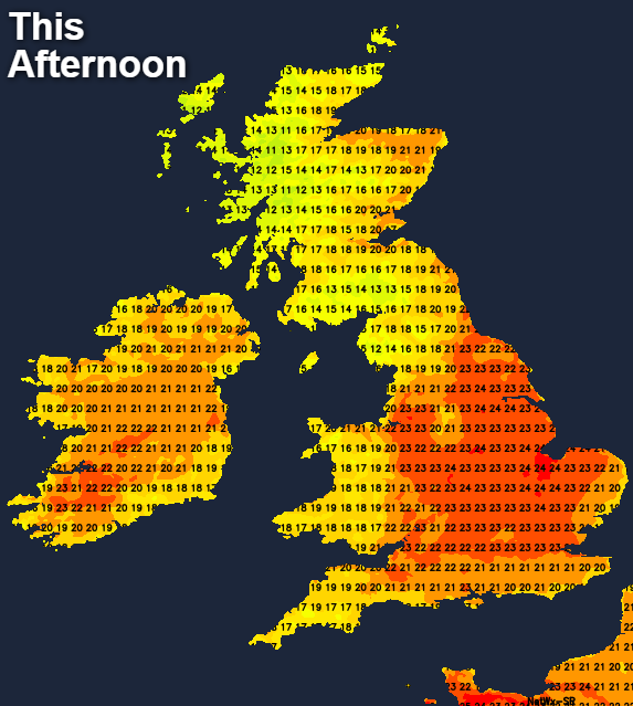
Today, the north and west of the country aren't getting in on the act though, with plenty of cloud and a few outbreaks of rain here. But elsewhere, once any mist and low cloud clear, there'll be plenty of sunshine. Temperatures will respond too, rising to 21-24c in many central and eastern regions.
Where the skies stay clearer in the southern and central regions, it'll be a chilly night to follow, with lows of 8-10c typical. In the cloudier zones, there'll still be some bits and pieces of rain in the far north and west, and temperatures will generally stay way out of single figures and for most will be in the teens.
Tomorrow brings a quite similar day to today. The patchy rain in the west will tend to clear from the south during the day, but at the same time, it's likely to become a bit more organised and heavy in the far northwest. Away from all that, another day of sunny spells with temperatures on par to today. One slight difference to today will be the winds, as they'll be stronger and even on the blustery side from northern England northwards.
Overnight Sunday and into Monday, some of that wetter weather in the northwest will sort itself out and make a move southeast. It'll be on a cold front, with cooler, fresher air being introduced behind it. By Monday morning, it'll be clear of Scotland, so lots of sunshine here, after a chilly start. The ever-weakening front will then move through northern England and Wales by early afternoon, bringing some outbreaks of rain but eventually clearing to brighter, sunny skies.
To the southeast of it, there'll be plenty of sun to start, but the cloud will fill in as the day progresses. The best of the warmth will be in the southeast corner, with highs into the twenties once again, but cooler under the front and distinctly fresher to the north of it.
The frontal zone will tend to stick in the south for a while overnight Monday and into Tuesday - there could be the odd patch of drizzly rain, but in the main, it'll just be a band of cloud at this point. Away to the north though, a chilly night will follow, with perhaps a touch of grass frost here and there.
Beyond that, the remainder of the week stays mostly dry, although a keen east to northeast wind is likely to affect the south of the country. Temperatures will still be on the warm side, with most parts seeing highs into the high teens or low-twenties, with western and central parts liable to regularly be the warmer spots.
If you're wondering about the longer term weather this Autumn, the long range Autumn forecast is now online, which you can read here.