Some sharp showers and thunderstorms are likely during the next couple of days, breaking the drought for some. The majority stay dry though with more very warm temperatures.
The somewhat lower temperatures of the past few days have come as a welcome relief for many but have done nothing to alleviate the drought situation. Cooler air is also heavier and denser so tends to sink, encouraging pressure to rise at the surface to further aid the drought. The air of cooler origin, however, is more unstable and as it mixes with warmer air today and tomorrow locally sharp hit and miss showers will break-out.
We already have a few showers around the Welsh borders and to the North of Manchester, but these'll fade. There are also quite large amounts of cloud this morning, that's giving some patchy light rain over Scotland.
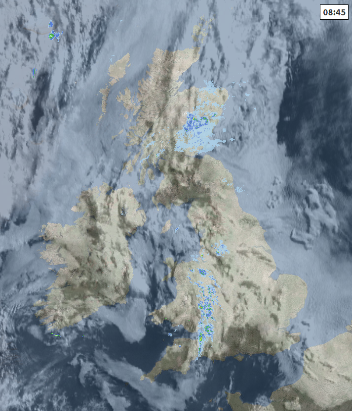
This too will peter-out in a day that'll brighten over Scotland especially to the south of the Forth/Clyde valley where together with Northern Ireland, there'll be some warm sunshine later. Most parts will be dry, but cloud amounts will vary, perhaps building sufficiently to give the odd sharp shower mostly towards Dumfries and Galloway where it's already quite sunny. Winds'll be light with top temperatures 18 to 22C except in the far North, and North West, where a cooler 14 to 16C is more likely.
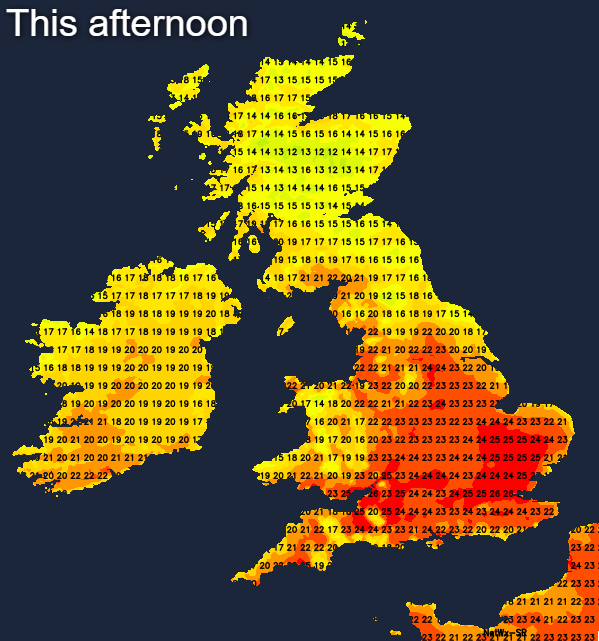
Over Wales and England, eastern areas, in particular, are waking to cloud and we also have those showers along the Welsh borders. Although cloud amounts will continue to vary, there's already some sunshine down the spine of England and over the West Country and South West, with the sun coming through in most parts later to give a very warm afternoon. Most places continue to be dry, in just a gentle breeze from a northerly quarter that'll keep the East coast cooler. As afternoon temperatures, however, reach a very warm 22 to 24C fairly generally and 25 or 26C in the sunnier spots.
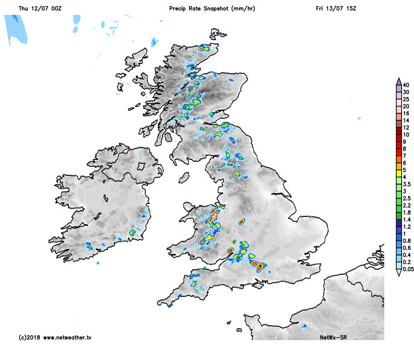
This'll trigger a few more sharp showers, mostly in the West. Where you catch one, it could be torrential giving thunder and the risk of local 'flash' flooding, but they'll be 'hit and miss' with most parts having yet another dry day.
Storm Forecast issued for today - read it here.
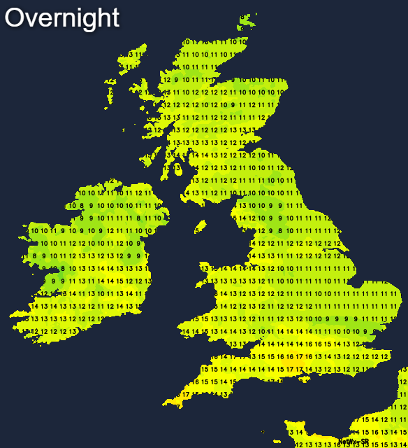
Cloud amounts will vary, but for most, it'll be a summery evening, with some further sunshine to end the day. The showers will largely fade after dark to leave a mainly dry night, but with low cloud and mist 'rolling-in' off the North Sea to affect many eastern counties again by dawn. Elsewhere there'll be clear spells, and with only a light breeze mostly from a northerly quarter, a few short-lived mist patches may form in some rural valleys towards morning. It'll be a very mild slightly humid night in the South where temperatures shouldn't fall below 14 to 16C, with 10 to 12C more likely further North.
While there'll continue to be a good deal of fine weather on Friday and most parts will stay dry, the risk of catching a heavy shower or thunderstorm from mid-afternoon will be more acute. Cloud mostly in East will lift and clear during the morning, allowing spells of very warm sunshine to come through again in most parts. Showers will develop through the afternoon, however, mostly over Wales, central southern England, the West Country, the West Midlands and in hilly areas further North. Some will again give local torrential downpours and with light winds, will be slow moving. This'll mean that some parts get a deluge, while others just a few miles 'down the road' see nothing.
 Most of Scotland and Northern Ireland will see sunny spells, and it'll become very warm where you have the best of the sunshine, with perhaps the odd heavy shower 'breaking-out' over the Southern Uplands later. Towards Donegal and Highland, however, a freshening southerly breeze will bring cloud and some patchy rain through the afternoon. Top temperatures here only 15 to 17C, with 18 to 24C more likely elsewhere. Over England and Wales temperatures should reach 23 to 26C fairly generally, with 27 or 28C possible in the sunnier spots across the South.
The showers will fade into the evening, leaving much of England and Wales with a dry night. Clearing skies and light winds will allow a few mist or fog patches to form again in rural areas towards dawn, but these'll be short-lived soon clearing after sunrise. The North and West of Scotland and Northern Ireland though will be cloudy in a southerly breeze, with patchy rain. It'll be a humid night over southern England, where temperatures shouldn't fall below 15 to 17C, but it'll be somewhat cooler further North where 10 to 13C is more likely.