Sunny May weather continues this weekend and also right into next week. Temperatures are on the up as well, with highs moving into the twenties from today.
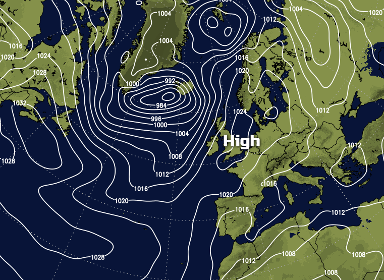
Apart from a few hiccups its been a lovely May so far, with more than 150 hours of sunshine already recorded in a good number of places up and down the country. With a large anticyclone continuing to dominate the scene, it'll remain fine and dry, in an increasingly warm weekend especially over England and Wales making it ideal for the Royal Wedding and the Scottish and F.A. Cup finals. Across Northern Ireland and the North and West of Scotland however although mainly dry today, you won't be quite so lucky with Atlantic systems bringing some rain by Sunday.
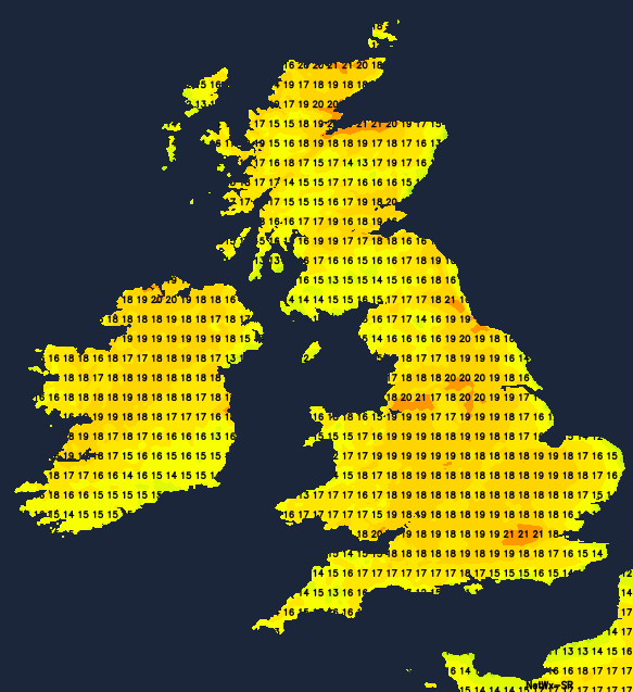
We have patchy cloud over Northern Ireland and some murk, mist and patchy drizzle over the Highland and the Northern Isles at the moment, but things will improve with the sun eventually coming through. For the remainder of the country, it'll be a fine day, and there'll be lots of sunshine, with any remaining mist and patchy fog soon clearing. There'll be some patchy cloud mostly towards Kent, to begin with, but this won't spoil a lovely day too much. After a chilly start, it'll become warm by the afternoon, with maximum temperatures mostly between 19 and 22C in generally light breezes. Over the North and West Scotland and Northern Ireland though, a southerly wind will freshen through the day keeping it somewhat cooler here, with the far North West and places towards Donegal, getting no higher than 13 to 16C.
Most of England and Wales together with the Fife, Lothian and The Borders continue fine, dry and sunny into the evening. A largely clear night will follow, and with a southerly breeze mostly light, it'll turn misty in places. A few fog patches will form towards dawn in rural areas together with a touch of grass frost in the coldest spots, but this'll be short-lived. East Anglia, the South East, the East Midlands and parts of central southern England may see very low cloud drifting in off the North Sea, making it grey here by morning when temperatures will mostly be in the range 4 to 7C. Across Northern Ireland and the North and West of Scotland, however, it'll become cloudy, with some rain or drizzle moving in overnight to more western areas. A southerly wind will also be more noticeable, but here, temperatures shouldn't fall below 8 to 10C.
Sunday will be another dry, fine day over most of England, Wales and South East Scotland with lots of sunshine again once early mist, patchy fog and areas of low cloud have cleared from the East and South East. Cumbria could be an exception, where you may see more cloud, perhaps with coastal mist and some patchy drizzle for a while. After a chilly start in places, it'll become warm or very warm again by the afternoon, with top temperatures 20 to 24C in just a light or moderate breeze from between East and South. Across Northern Ireland and North West Scotland however, it'll be cloudy with patchy rain or drizzle in a mostly moderate or fresh southerly wind. As a result, it'll be cooler here, with temperatures generally getting no higher 12 to 14C.
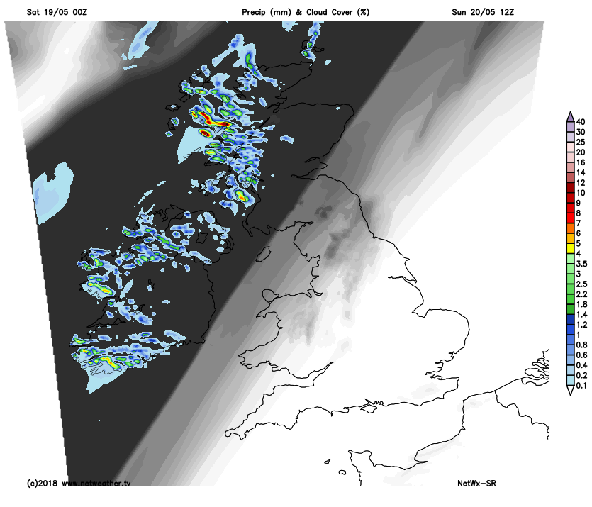 Northern Ireland and the North and West of Scotland keep a good deal of cloud and mist into the evening and overnight. Further patchy rain and drizzle are expected although later in the night, Down and Armagh together with Dumfries and Strathclyde may see skies beginning to break. Across the remainder of the country after a sunny early evening, it continues fine overnight with clear spells in light winds. This'll allow mist and patchy fog to form again in rural valleys, with areas of very low cloud perhaps returning to some eastern regions. It'll turn chilly again in some rural parts towards morning, with lowest temperatures mostly in the range 5 to 10C.
While you'll continue to see some sunshine into the new working week, it's likely to become more mixed across England and Wales. Southern parts, in particular, will see showers breaking out some locally heavy with thunder, but they'll be 'hit and miss' affairs and therefore not everywhere will catch one. Over Scotland and Northern Ireland however, after some rain in the North and West at first, the trend will be for increasingly fine, dry, sunny weather through the week, especially in the West.