Most of us have had a taste of winter with some snow and plenty of frosty nights in the last few weeks, with many locations recording way more frosts than the last few Decembers to this date. We will see a lot of dry weather for the rest of this week, as high pressure dominates our weather. However, after the chilly start for some in the south and east, it will turn increasingly mild for many across England and Wales, after a mild start to the week, cooler for a time across Scotland, before milder conditions spread across all parts to end the week and through the weekend. Although there will be some rain around before Christmas day, more particularly for the far north, for many it will be mostly dry if rather cloudy at times. But we will see a change to increasingly unsettled, wet and even stormy weather from Christmas Day and throughout next week until the New Year.
After a fine day on Tuesday, cloudy skies have spread south for many to end the day and the patchy rain or drizzle across the far north today along a cold front, will sink south and become stuck across central areas tomorrow and Thursday, with cloudier skies lingering here and to the south, while it turns drier and brighter from the northwest across Scotland.
There will be somewhat topsy-turvy contrasts in temperatures across the UK for the next few days too. First thing this morning southern England was the coldest part of the country with temperatures as low as -4C at dawn, while in the NE of Scotland it was 15C, thanks to the Foehn effect of the southwesterly flow here.
The milder and cloudy conditions in the northwest will spread south by tonight behind a warm front, bringing milder air to southern areas. However, a cold front moves in from the northwest on Wednesday morning, so by the afternoon the coldest air will be over Scotland to the north of frontal boundary straddling central areas of the UK, while to the south it will be milder.

The frontal boundary north-south divide will try and sink a little further south on Thursday, but it will lift back northeast on Friday, as high pressure loses its grip, the isobars tighten and the southwesterly flow strengthens.
So, it will turn milder across all areas to end the week and into the weekend. However, although western parts may see a little patchy rain to end the week, it to looks to remain predominantly dry but mild across much of England and Wales through the weekend for many, away from NW England, as high pressure tries to reassert itself to the south. For Scotland it looks a more unsettled and windy picture, with rain at times. The rain could be heavy and prolonged across western Scotland, given the moist southwesterly flow indicated, so we may need to keep a close eye on rainfall totals here.
Could be wet in the far NW this weekend, mostly dry if cloudy elsewhere. Credit: wxcharts.eu:

There is some uncertainty over the details for Christmas Day on Monday, but it looks like the increasingly unsettled and windy weather across Scotland will become more widespread by the end of the day, as wind and rain move in from the west across all areas. But eastern areas of England could escape with dry and bright weather until later in the day. For a white Christmas, any snow looks to be confined to the Scottish mountains, as colder polar air filters in from the northwest.
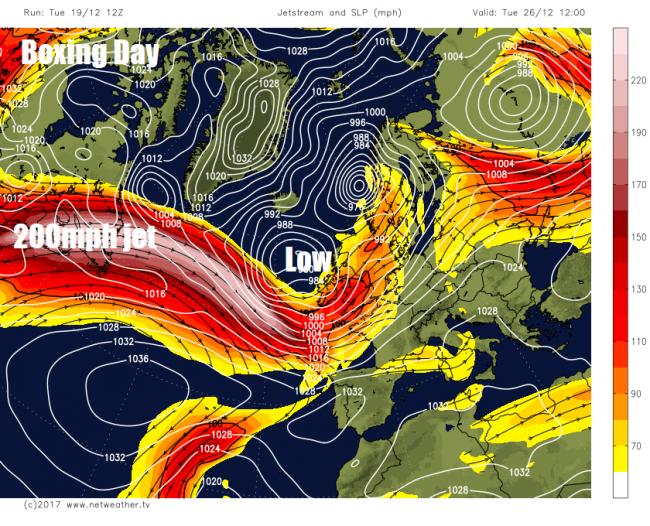
The general consensus from model guidance recently is for the weather turn increasingly unsettled next week, as the jet stream that's to the north of the UK this week sinks south and strengthens, with the risk of a few deep depressions developing to the west over the Atlantic crossing over or near the UK and Ireland, bringing wet and potentially very windy weather.
The reason for the arrival of a stormy period of weather next week is likely linked to a large wedge of deep and intensely cold air over Canada surging south across N America into the U.S. as a result of a buckling of the upper flow upstream by a strong ridge over the NE Pacific building poleward over Alaska and forcing cold air south downstream. The extreme cold pool of air over North America, a lobe of the tropospheric polar vortex (TPV), will induce a strong thermal gradient along the boundary of cold polar air of the TPV and that of warm tropical martime air off the eastern seaboard of N America and will in turn strengthen the polar jet stream marking the boundary.
Watch the cold pool (part of polar vortex) over Canada swing south then east, tightening the gradient and deepening lows over the Atlantic toward UK and Ireland:

The strong polar front jet will extend eastward over the far north Atlantic towards NW Europe, potentially spawning deep cyclogenesis or ‘bombogenesis' of depressions moving east with the strong jet stream. Such deep lows could bring severe gales or storm force winds.
So there is a risk of one or two deep lows, perhaps becoming named by the Met Office, moving near or over the UK next week, bringing a risk of disruption when a lot of people will be travelling. So keep an eye on forecast over the next few days, we will certainly be keeping an eye on developments from model guidance over the festive period. Also, there looks like there could be cold polar air sweeping behind these systems from the north and northwest, particularly from Wednesday onwards, which could bring some wintriness to northern and western areas, with snow over higher ground in these areas. Certainly plenty happening weather-wise next week!
Loading recent activity...