Ex-tropical storm Rina has brought rain to many parts of England and Wales to start the weekend. But the colder clear air further north, will move south later.
You'll need to 'wrap up' well for the many Remembrance Day services up and down the country this weekend, as cold Arctic air feeds down from the North reaching all parts by Sunday. For today though it's somewhat of a North/South split, as meandering fronts initially containing the remnants of ex-tropical storm 'Rina', affect some central and southern parts of England and Wales.
For Scotland and the far North of England, it's a bright but cold start to Armistice Day, with a frost in places. There'll be sunny spells especially over sheltered central and southern parts of Scotland, this spreading to Northern Ireland through the morning and to remaining parts of northern England through the day. There are already a few showers over northern Scotland and around the Moray Firth, however, some heavy and wintry on hills, with others developing in the West mostly towards the coast and over Derry and Antrim later. It'll feel increasingly raw as a cold North West wind freshens a little, with top temperatures only 6 to 9C.
For remaining parts of England and Wales, it's a different story this morning. It's cloudy with some rain heavy in places across much of the South but here it's much milder. It's also quite blustery over South Wales and the South West, with a fresh or strong West wind giving gale force gusts across the Channel Islands. Further bursts of rain are expected through the day mostly across the South and South West, while much of the Midlands, East Anglia and later North Wales see lighter breezes and colder weather moving in. Top temperatures here about 8 or 9C but further South it'll stay mild, where 11 to 13C is more likely.
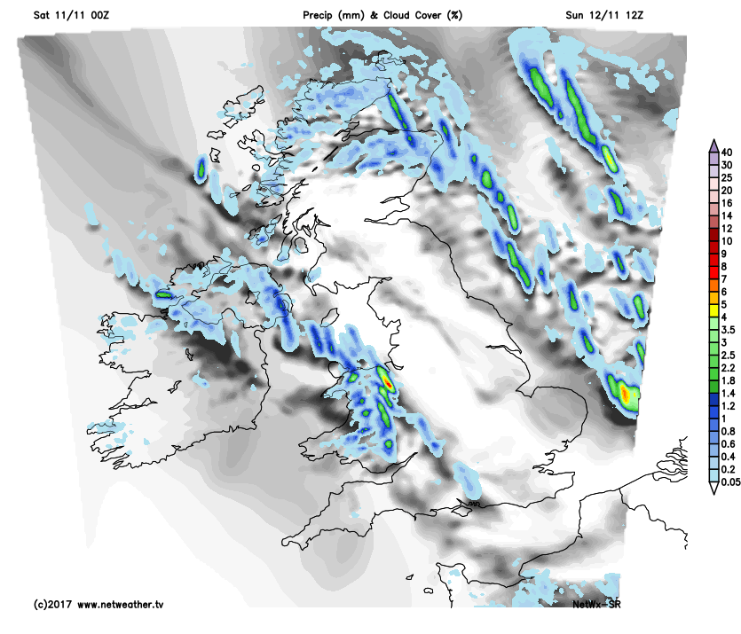
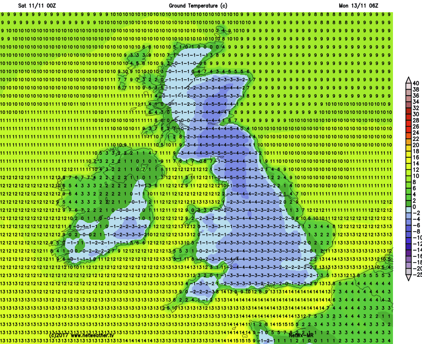
South Wales, the South West and southern England mainly South of the Thames see additional pulses of rain moving from West to East through the evening, before the colder, clearer air to the North eventually spreads to all parts during the night. Meanwhile, showers will continue to affect the North and East of Scotland, Northern Ireland and coastal areas exposed to a blustery and quite raw North Westerly wind. Some of the showers will be heavy and wintry over North East Scotland, with a covering of snow possible over the higher peaks of Highland and Grampian by dawn. Inland lighter breezes and clear spells will allow a slight frost to develop in Scottish glens and in sheltered rural valleys of the North, with lowest temperatures -1 to +3C in the North and 5 to 7C further South.
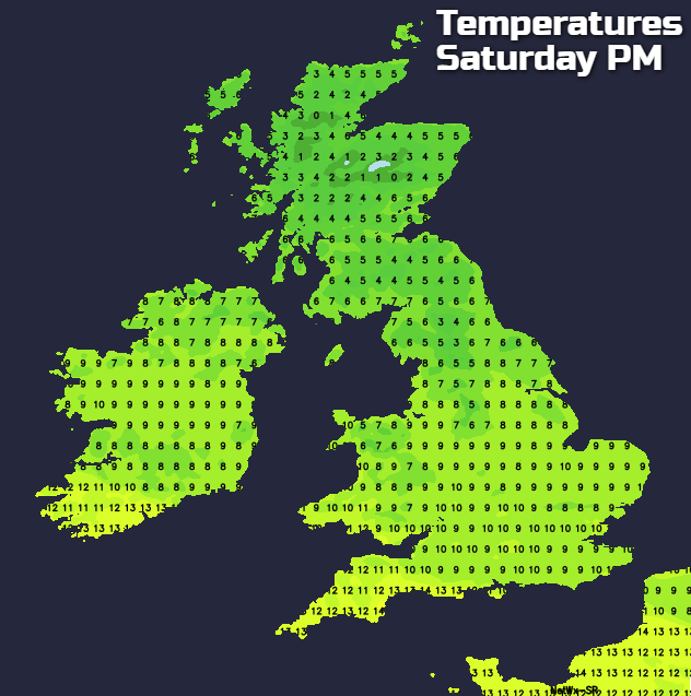
Remembrance Sunday sees us all 'in the same boat' in rather cold, crisp somewhat blustery conditions. Sheltered central and southern parts of both Scotland and England, should see lots of sharp sunshine with only the odd passing shower. However, across Northern Ireland, the West, North and East of Scotland and towards coasts of England and Wales exposed to a blustery North or North West wind, the showers will be more frequent. A few will be heavy and wintry in the North giving hail, with snow on Scottish hills accumulating on the higher peaks of the Cairngorm and Grampian mountains.
 Despite the sunshine inland it'll be rather cold and feel raw in the wind, particularly if you catch a shower. As a result, temperatures are unlikely to get above 5 or 6C in the North and 7 to 10C in the South.
Further showers wintry in places giving hill snow are likely after dark particularly over, the North and East of Scotland, towards the East coast and across Norfolk. Some will also come through 'The Cheshire Gap' to affect parts of Merseyside and the West Midlands, but they'll fade from Northern Ireland, as a blustery North or North West wind begins to decrease. Many inland areas become clear leading to a widespread frost, with temperatures mostly in the range -2 to +5C by morning.
Although cold at first into the new working week, Atlantic systems will soon bring the return of milder weather. There'll be some rain particularly over Scotland, but this'll be lighter and patchy in the South, with the South East perhaps becoming mainly dry and quieter by mid-week.