
Category 4 or even 5 Hurricane Matthew to hit Florida early Friday - bringing destructive winds, life threatening storm surge and flooding rains.
*UPDATE 8am*
Hurricane Matthew, now Cat. 3 hurricane, with maximum ssustained winds of 120mph near eye wall, is nearing the Florida Space Coast with dangerous storm surge, destructive winds and flooding rainfall stretching into Georgia and South Carolina by the weekend.
Tropical storm-force winds have already been impacting Florida's east coast for the past several hours. Melbourne International Airport has gusted as high as 70 mph, so far. 71 mph gusts were also reported in Jensen and Vero Beaches in Florida.
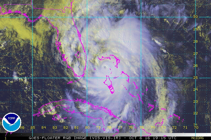
The eyewall, or the most destructive portion of a hurricane, is just 45 miles east off the coast of Vero Beach, Florida.
Death toll in Haiti from Hurricane Matthew soars past 300.
10 Key Points about Matthew:
Hurricane Matthew continued to churn through the centre of the Bahamas Archipelago during Thursday, bringing flooding rains, high winds and dangerous surf. Matthew has now become an extremely dangerous Category 4 Hurricane, with maximum sustained winds of 140mph. The centre of Matthew will continue to move northwest at around 14mph across the northwestern Bahamas this evening, before reaching the east coast of Florida tonight as a Cat. 4 Hurricane.
Radar image of Hurricane Matthew approaching Florida from the Bahamas Thursday evening:

Matthew, the 13th named storm of the 2016 Atlantic hurricane season, is also the strongest storm since Hurricane Felix in 2007. Matthew first began its development as a disturbance over the Atlantic Ocean more than 10 days ago. By the time it reaches Florida, it will have traveled more than 3,000 miles.
The hurricane wreaked havoc on its rampage across the Caribbean since the beginning of the weekend. The death toll in struggling Haiti alone rising to 108 people, local officials said today, before the storm headed northward wreaking destruction over eastern Cuba and today battering the Bahamas en route to Florida tonight. The hurricane has left a trail of destruction across Haiti, the Dominican Republic, Cuba and now the Bahamas. But for impoverished Haiti, Matthew’s landfall as a category 4 hurricane with winds up to 140 mph has left a potential humanitarian crisis for one of the world's poorest countries, which is still recovering from a 2010 earthquake that killed more than 200,000 people, as well as a cholera epidemic that followed.

History of Matthew, courtesy of The Weather Channel
Matthew briefly reached Category 5 hurricane status — with winds exceeding 157 mph (252 km/h) on October 1st. Matthew dropped to Category 4 strength soon after, with maximum sustained winds calculated at a still-dizzying 140 mph (225 km/h) on October 3rd. Hurricane Matthew made landfall on southwestern Haiti as a category-4 storm on October 4th - the strongest storm to hit the Caribbean nation in more than 50 years. The centre of the storm then continued across the far eastern tip of Cuba on Wednesday making its second landfall after Haiti still as a Category 4 hurricane before weakening over the mountainous terrain over Cuba into a category 3 storm before heading to the Bahamas earlier today.

Hurricanes can take a day to re-strengthen as they pass out over warm ocean waters after weakening over land. However, after Matthews eye filled in, it re-appeared and strengthened today along with an increase in lightning activity on the northeast flank of the storm – indicating that conditions today were favourable for continued strengthening and so it was upgraded to an extremely dangerous category 4 hurricane as it crossed the northwestern Bahamas and now approaches the east coast of Florida tonight. `

The centre of hurricane Matthew is expected to move very close to the east coast of Florida later tonight and follow the coast north during Friday before curving northeast just offshore of Georgia and South Carolina during Saturday. Initially arriving as a Cat. 4 Hurricane, before weakening to 3 then 2 later on Friday and over the weekend, as the hurricane interacts with stronger wind shear to the north and land interaction of the eastern seaboard. The centre is expected to pass very close to Miami in the early hours of Friday local time.

The outer convective bands of Matthew have already spread across Florida while nearly 2 million people along the U.S. East Coast, 1.5 million of which are in Florida, have been urged to evacuate their homes near Atlantic coasts of Florida, Georgia and the Carolinas. Winds of 135-156mph are expected to batter Florida’s east coast on Friday, as it makes landfall as a Cat. 4 hurricane, which will be powerful enough to rip off roofs and fell most trees and power poles. Combine the destructive winds with the risk of storm surges along coastal settlements and up to 10 inches of rain falling in some spots, there is real concern that Matthew could have catastrophic consequences for the east coast of SE U.S. over the next few days. The last Category 3 storm or higher to hit the US was Wilma in October 2005, when it killed five people, caused billions of dollars in damage and left thousands of residents without power for more than a week.
In brief, what southeasten USA can expect from Matthew:

Forecast rainfall from Matthew:

Forecast storm surge for Matthew, courtesy of The WeatherChannel:
:
And Finally ... the already rare event of such a strong hurricane hitting Florida in October, Matthew may take the even more bizarre twist of doing a full loop over the Atlantic swinging back across the Bahamas again, though weaker by then, as per recent model ensemble runs:


.jpg?w=350)

