Hotter again for Thursday! It’s been quite a week, with building heat, some cracking thunderstorms for Somerset on Monday evening and others over London and the Home Counties during the small hours. Then, extreme heat with Amber and Red warnings from the Met Office. No one in southern Britain needed disrupted sleep before heatwave conditions truly set in and exceptionally hot, humid air arrived from France. France saw its hottest ever day on record on Tuesday 23rd. And the UK followed with it's hottest June day on record.
Update 6pm Thursday - Provisional new June record Merryfield, Somerset 36.7C
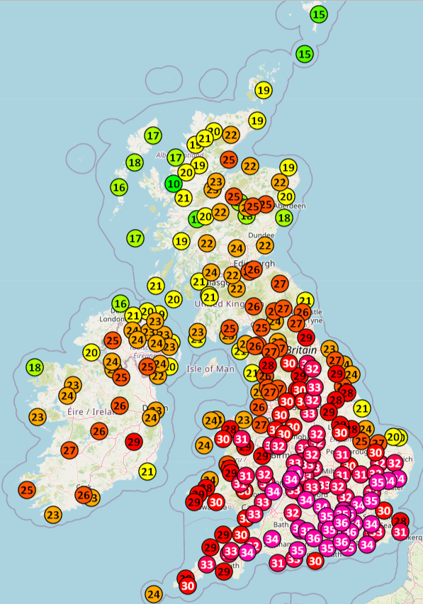
Starlings Roost data for Wednesday 24th June, record breaking highs
Wednesday 24th June, saw the UK’s June record from 1976 fall. Gosport in Hampshire provisionally reached 36.1C, Wisley 36.0C, Charlwood 35.7C both in Surrey and Wiggonholt, W.Sussex 35.9C; all above the previous 35.6C record in grim, hot and humid air.
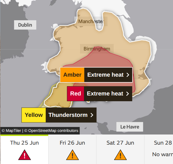
“An exceptional spell of hot and humid weather is expected across this region, with impacts to the general population highly likely.” Met Office
The Extreme Heat warnings continue across a large part of England and Wales. Be aware that some parts of central/southern/western England and in Wales are now on day four of official heatwave conditions. This with the humid, very warm nights, will be taking a toll on some people. Schools have been closed, or are operating half days. Events have been cancelled and there has been disruption to some railway services with pleas to only travel in this exceptional heat if it is essential for the rest of the working week. It will be very wearing again today. There is a breeze off the North Sea and there has been a bank of low cloud swing down towards the east coast of Britain overnight.
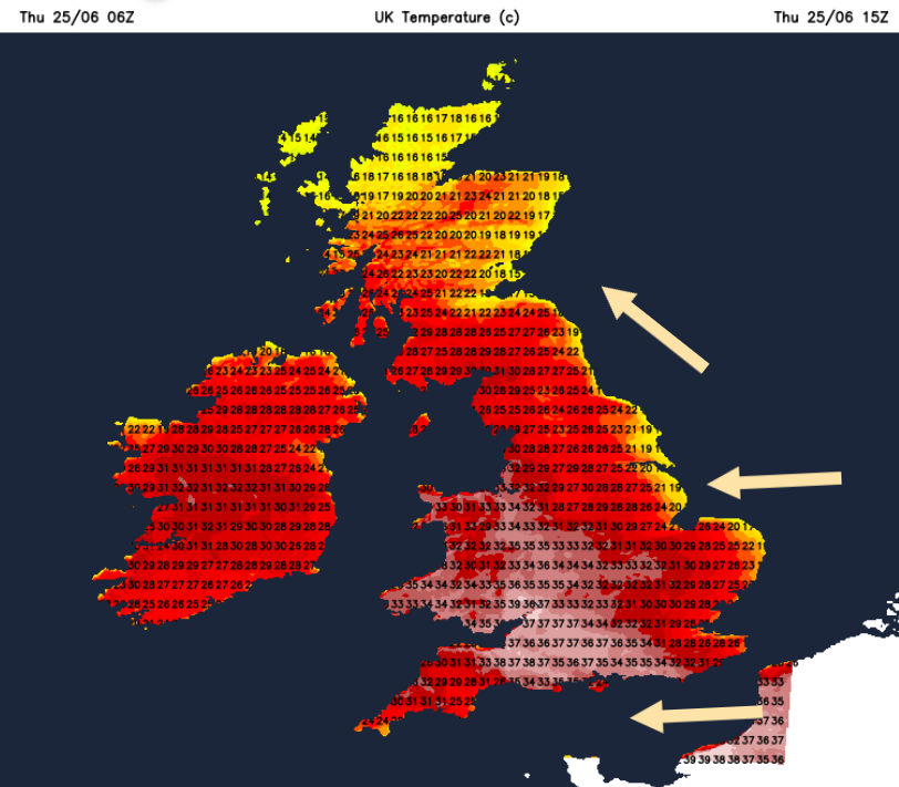
The highest temperatures will be for central southern England, around the West Country, the south and West Midlands and for Wales. Again up into the mid 30sC with 38 or even 39C possible. The new June record will not last for long.
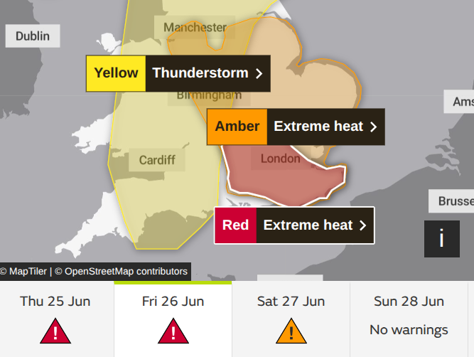
“Hot and humid weather is expected to continue through the middle of the week, with exceptionally warm temperatures both day and night.” Met Office
The Extreme Heat will still be around on Friday, The Met Office has now extended the Red Extreme Heat warning. The amber warning still highlights High Impacts from the intense heat. Relief for Wales by Friday with a light southwesterly wind and a real change for Northern Ireland after a hot Thursday. A dig of fresher air from the northeast will lower temperatures over northern mainland Scotland, but it will still be very warm in the S/SW after a hot Thursday.
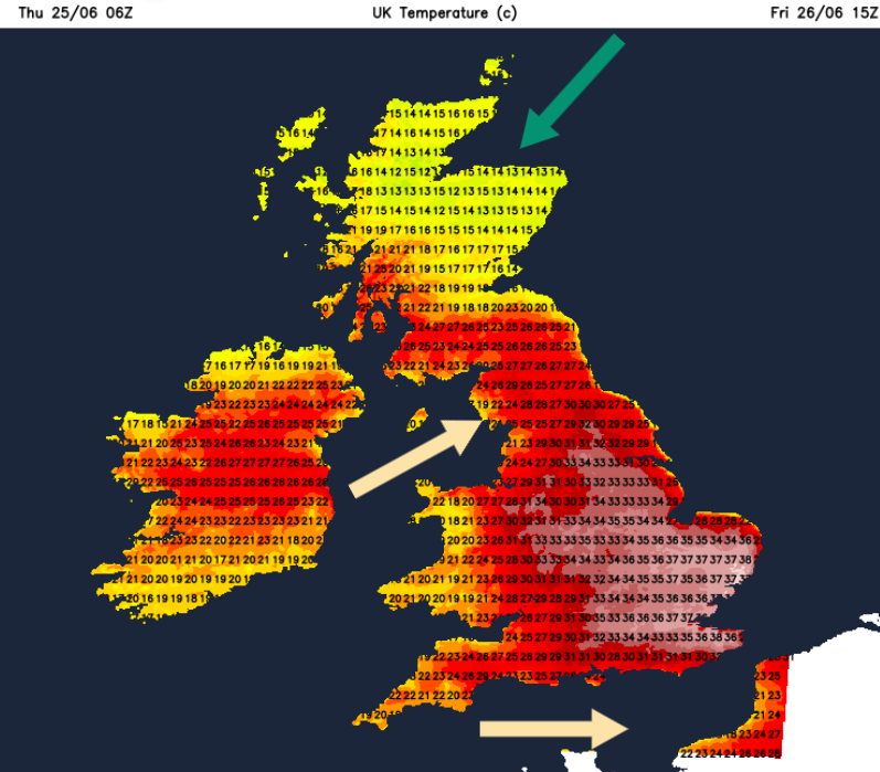
The Amber extreme heat area shrinks further by Saturday, which is of little comfort for Anglia, London and the Home Counties as the hot days and uncomfortable nights continue with hardly any breeze. Elsewhere there will be a southerly wind, taking the heat northwards so for the eastern half of Scotland and northeast England, it will be very warm on Saturday.
Finally, on Sunday the flow will back to a southwesterly off the Atlantic, and the air will change by the end of the weekend for those in the Extreme Heat regions. Northern Ireland and Western Scotland will have seen showery rain on Saturday, across western Britain on Saturday night, and the change will reach eastwards over Wales and England during Sunday.
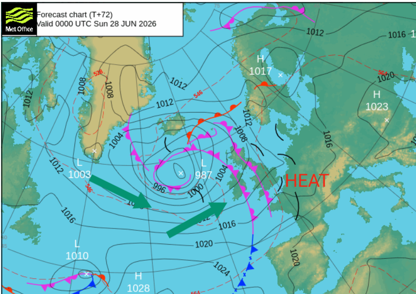
It will feel different, fresher but still warm in any sunshine. There will be more cloud as fronts move by and outbreaks of rain, but it is a mixed picture for Sunday.
Today, Thursday 25th
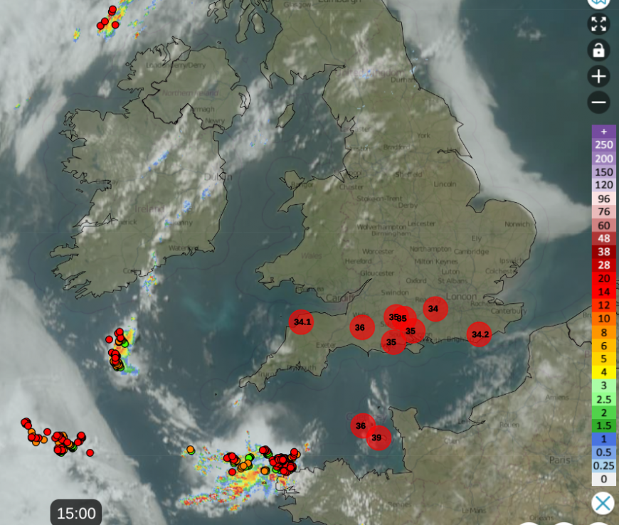
Netweather Radar at 15:00 with haar/SeaFret along east coast, thunderstorms off NW France and intense heat for Britain. Showing top ten temperatures including the 36.4C at Yeovil, Somerset
Jersey Met have announced a temperature of 39.3C Maison St.Louis Observatory. This has surpassed the highest recorded temperature on the island of 37.9C, back in July 2022.
Mixed in with all this heat will be the threat of thunderstorms. Nick Finnis will update later today. Like on Monday, there is a huge amount of potential energy available in the atmosphere today. There have already been thunderstorms set off over the Brest peninsula, NW France.
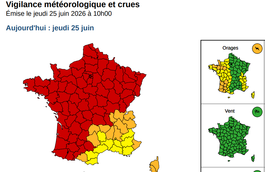
Meteo France warnings for Canicle (Heatwave) across the country, and Orages (Thunderstorms)
There is a warm front bringing rain over the far north of Scotland, which will include heavy pulses over the NW Highlands into the night. There is a risk of thunderstorms in this region, see below. There will be heavy bursts on Friday over central and eastern parts of Scotland, welcome rain for eastern Scotland, where there are Alerts for Water Scarcity but patchy outbreaks.
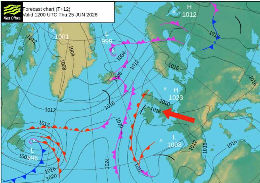
The high pressure is over the North Sea and the feed of hot and humid air around that is coming from continental Europe. There is hardly a cloud in the sky so the sunshine continues to heat the ground and the temperatures are rising.
SouthEast Water has issued a Temporary Use Ban (TUB), a hosepipe ban if you like, for customers in Kent to use water sparingly, “ Due to sustained high temperatures and near record levels of demand for treated drinking water”
“The restrictions mean that you should not use hosepipes for watering gardens, washing cars, patios and boats and for filling swimming and paddling pools.” SE Water
The problem with thunderstorms is that they are more likely to cause flash flooding, as happened earlier this week, than help replenish water supplies. These storms are very localised and deliver torrential downpours in a short amount of time, which often overwhelms drains and causes runoff issues when grassed areas are baked hard.
Southwest England has been highlighted by the Met Office later on Thursday and NW Scotland this afternoon, with all of Scotland covered by a yellow thunderstorm warning on Friday. Remember, with thunderstorms, these are clusters of showers with wide areas not seeing anything.
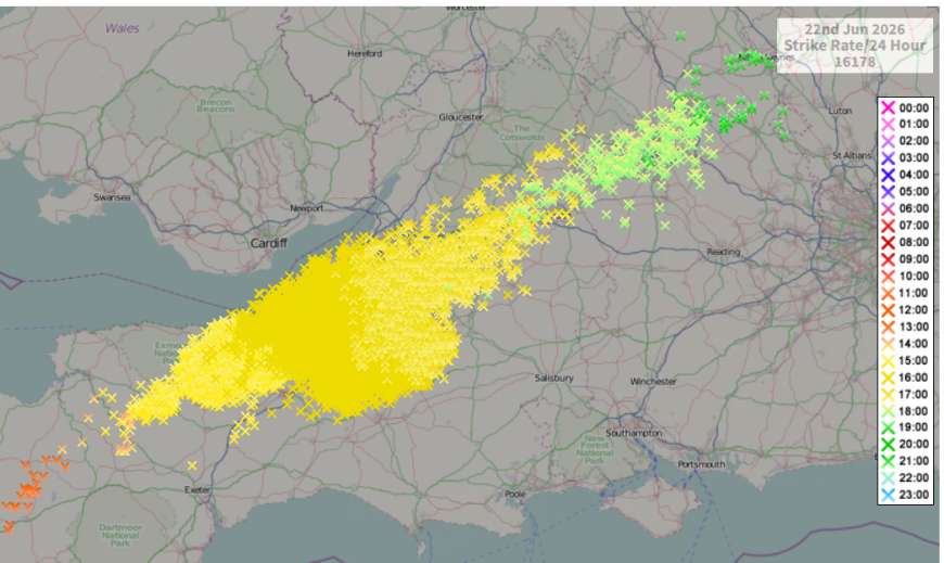
The phenomenal system on Monday over Glastonbury brought thousands of lightning strikes and torrential downpours but only along its path.
Risk of Thunderstorms Thursday into Friday morning
England and Wales - in the hot and humid air, "development of strong elevated thunderstorms which will move N and NE across parts of England and Wales later today. Uncertainty over the extent of thunderstorms, … but a broad consensus is for thunderstorms to develop more widely over NW France and intensify before moving NNE across SW England by early evening, then across Wales, Midlands and up towards N England through the evening and into the night. Another round of elevated thunderstorms may also develop and move NE further east across S England, Midlands and E Anglia from around dawn and through Friday morning”
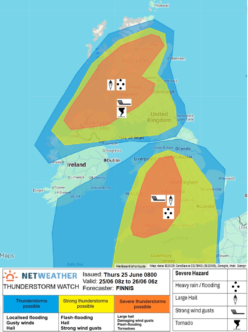
The Convective Forecast for Thursday and overnight highlights “Some thunderstorms may be severe: localised microbursts from downdrafts (given high bases of storms after crossing the English Channel) may produce damaging wind gusts of 60-70mph, storms may also be accompanied by hail, intense rainfall leading to flash-flooding (40mm in a short space of time) and frequent CG lightning. Storms may organise into a MCS across E Wales and the W of England before reaching N England - so a more organised risk of severe weather looks more likely than further east - where storms may be more scattered.” MCS= Mesoscale Convective System
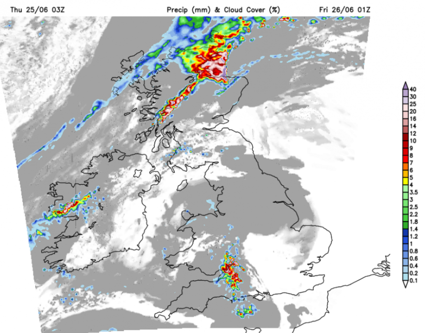
UKV model forecast for Thursday night precipitation
N. Ireland, Scotland and N England
A separate area for thunderstorms is being monitored for N. Ireland, Scotland and N England - “development of thunderstorms, which will likely organise into clusters or line segments and could locally be severe, … with risk of isolated large hail (4-5cm diameter, intense rainfall (40-50mm in a short space of time) leading to flash-flooding and damaging wind gusts (50-60mph). Frequent CG lightning will be an additional hazard…a risk of a tornado or two from stronger storms that can become surface-based.” CG = Cloud to Ground
Loading recent activity...