
Back to heatwave conditions with temperatures moving to 30 C at the weekend. It will be hot by day but uncomfortable by night. The heat starts to build on Wednesday with changes next week.
We have a run of hot days coming up with blazing sunshine, higher humidity and muggy nights. London will rise from 28C on Wednesday, 31C on Thursday, up to 32 or 33C at the weekend, which would be 5 or 6 days of heatwave. In Glasgow, temperatures could reach 26C by Friday, then up to 29C at the weekend, which would also match the heatwave criteria.
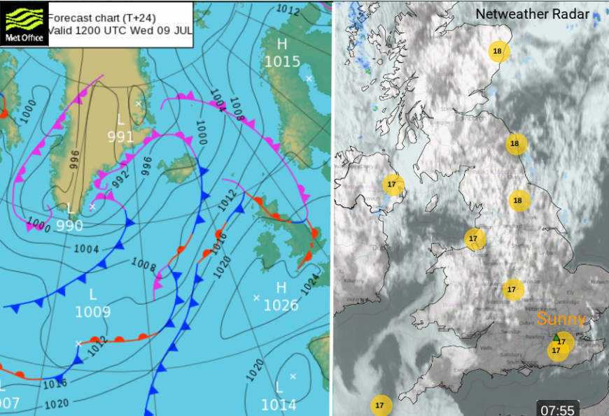
More cloud over the UK on Wednesday from weak weather fronts, sunnier for SE Britain but patchy rain for west coast Scotland.
High pressure is building over the UK with light winds and gradually less cloud cover with plenty of sunshine. In the steady conditions, there will be little movement of the air over the warming ground so it will continue to heat up each day. By this weekend, it is expected that parts of southern Britain will be into heatwave conditions, with several days with temperatures in the high 20sC, even above 30C for a few days. The nights will be hot and uncomfortable and it might be worth adjusting plans after considering the potential heat effects. Things should change early next week.
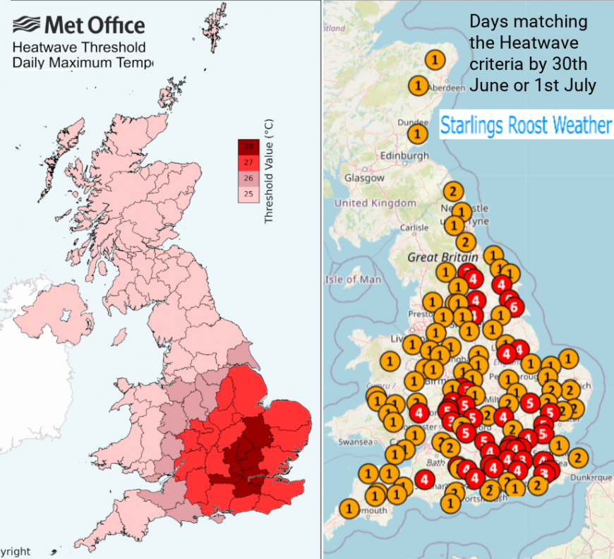
Official heatwave criteria thresholds, needing three consecutive days at or above these values. Data from the last heatwave shows the number of days meeting the criteria across Britain.
Wimbledon started in heatwave conditions which lasted through Monday 30th June and Tuesday 1st July before a change midweek. It remained warm but not the intense heat and humidity of the heatwave start. A third heatwave of the summer is forecast for this week, again lasting through the weekend , into the start of the new working week but then easing as the Atlantic brings in fresher air, perhaps by Monday or Tuesday.
The top temperature on Tuesday 8th July was 25.8C at Pershore. The highest temperature recorded so far this year in the UK is 35.8C at Faversham. The UK record is 40.3C from July 2022 when England, Wales and Scotland all broke their highest temperature records in a time of extreme heat.
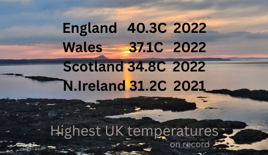
July is typically the hottest month of the year in the UK, all these records are from the month of July.
Today, Western Scotland and NW England have enough of a westerly wind that conditions remain fresher here on Wednesday as the air is stirred and moving off the North Atlantic.
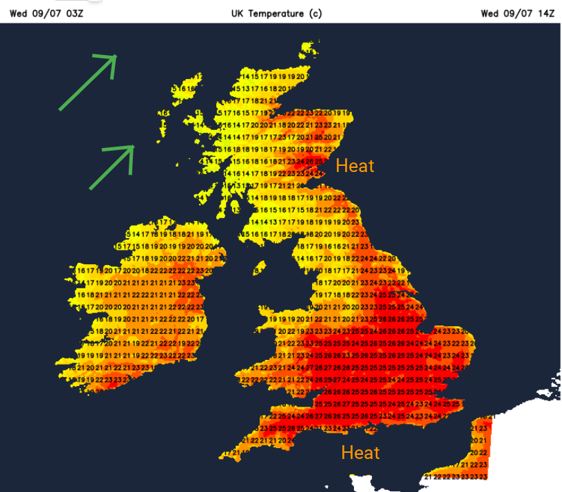
On the other side of Britain, temperatures are expected to rise, the Foehn Effect will dry and warm the air which has travelled over the Scottish mountains to get to Grampian and Fife. For a good part of southern Britain and eastern England, it will feel warmer today, especially in the sunshine. With very light winds, temperatures will widely rise into the mid to high twenties.
Conditions look incredible for the Scottish Open golf in East Lothian this week. With building heat and sunshine, there will be a pleasant breeze from Thursday through til Sunday. The organisers will be very pleased with this forecast.
The high pressure tries its best to keep the Atlantic weather fronts at bay, forcing them away to the northwest or north. The Scottish Islands will continue to see more cloud and patchy rain from passing fronts but by Friday, everything will be pushed northwards and all of the UK will feel much warmer and see more sunshine.
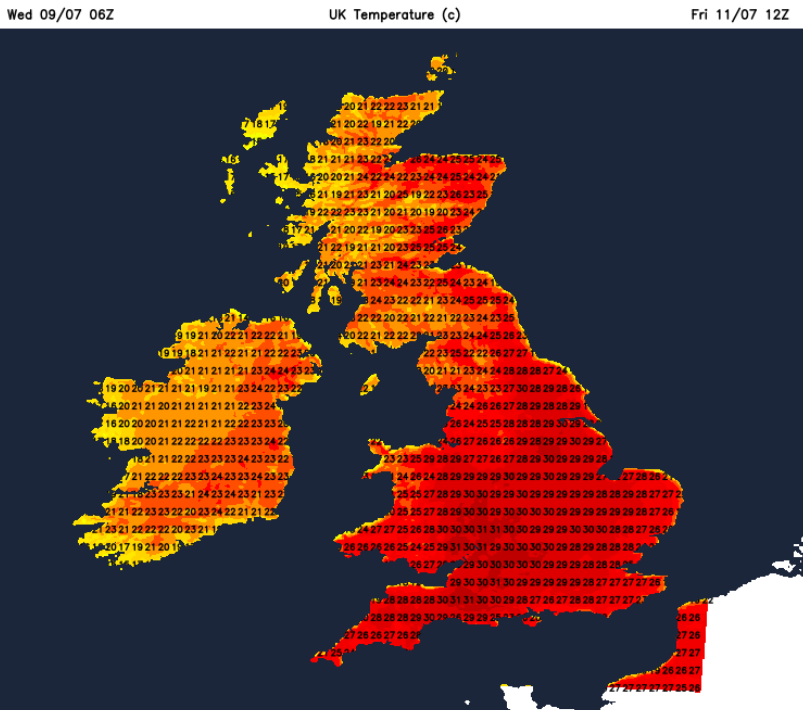
As the week progresses, the UK receives a flow of hot and humid air from Spain. This, combined with the clear skies and ongoing sunshine, keeps the heatwave conditions going, widely across England and Wales by Saturday with temperatures peaking at 33, even 34C. Whilst the high pressure has been shielding the UK, a large low pressure system over eastern Europe will spin up to the Baltic States and roll its fronts over Poland and southern Scandinavia. These will bring heavy, thundery downpours to parts of northern Europe. As the weekend continues, there will be low cloud ahead of these fronts pushing over the North Sea towards the Northern Isles on Saturday and then reaching eastern Britain later on Sunday.
For the Wimbledon finals, it looks fiercely hot on Saturday. By Sunday, the focus of the heat will be over central England, eastern Wales and up to Merseyside. However, another hot day at Wimbledon after one of several uncomfortable nights.
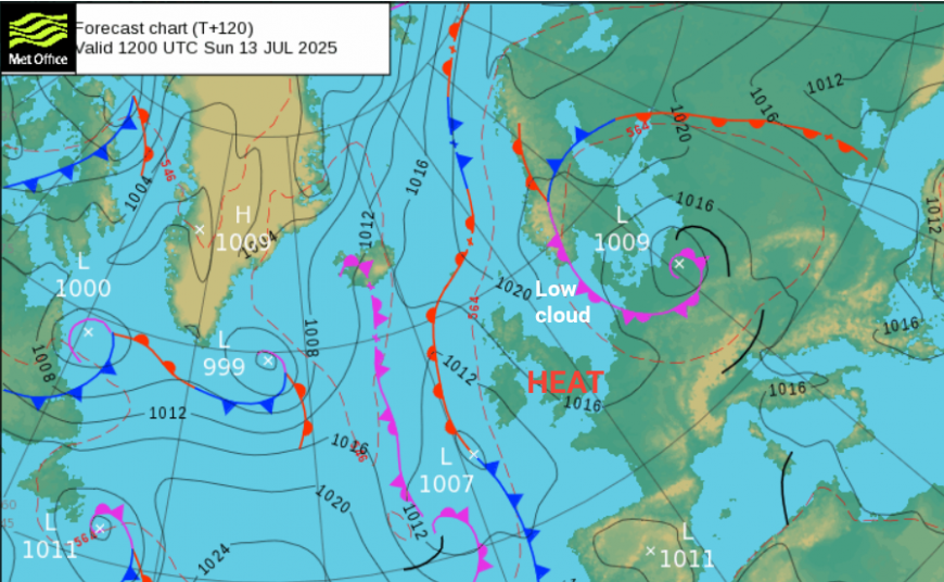
Out to the west is a lurking weather front which should be kept at bay during the weekend by the high pressure but things begin to change on Sunday night. As outbreaks of rain reach Northern Ireland, some areas will see a different day on Monday.
We have the low cloud and so fresher air from the North Sea coming in from the east and northeast. Then this frontal rain from the Atlantic meets the hot air which has been over the UK for days, so thundery downpours are possible. The region in between will hold the heat for another day, but it does look like the start of next week will bring a shift.
Loading recent activity...