For parts of the UK it has been warm and sunny with a sense of wellbeing that winter may finally be behind us. Forecast alert, it's still March and it will be cold again next week.
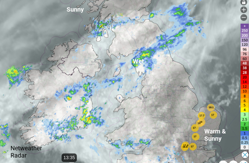
The British weather is fickle. It felt like spring was in the air on Thursday as temperatures rose into the mid to high teens accompanied by warm sunshine and blooming flowers. Santon Downham in Suffolk reached 19C, 18.8C in Northumberland, Ceredigion 18.2C and London 18.3C on the 6th March. Southeastern Britain has seen more warmth and sunshine on Friday with RAF Mildenhall recording 19C at lunchtime.
By Tuesday next week, many places could be closer to 8C, back to frost by night and even snow for the high ground of NE Britain. However, it is only March. Too early to get carried away with a few warm days.
With high pressure over SE Europe and the Black Sea we have benefited from a mild southerly flow from western Europe combined with glorious sunshine. Weather fronts have troubled the far northwest with cloud and outbreaks of rain for Scotland and these have reached further east on Friday. By Saturday morning, the warm front will be over the far north of Scotland but we can’t forget about that. A cold front will approach Cornwall in the middle of Sunday, but that one isn’t going to change our UK temperatures. Don’t think that we are clear of winter, next week looks colder.
This mild flow, and a good deal of bright or sunny weather, will last through the weekend. However, do not think that this is the opportunity to put away the winter clothes or swap to a lighter duvet. Cold air will return next week from the northeast. March can be a funny month with tantalizing warmth in the sunshine or a real chill in passing showers that give the impression there was something icy in the downpour.
Downward trend for temperatures next week
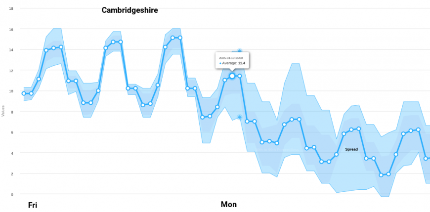
The temperature graphs show the diurnal peaks and troughs with values peaking in the mid teens over the next few days in London. 14 to 17 maybe 18C looks possible by day and dipping away to around 7C by night. Further along the graph you can see a downward trend. Next week looks colder, even with the spread of solutions from the GFS model. By night there could be frost for the Home Counties and by day, temperatures will struggle past 9 or 10C as a northeast to northerly flow sets in. The winds look very light though.
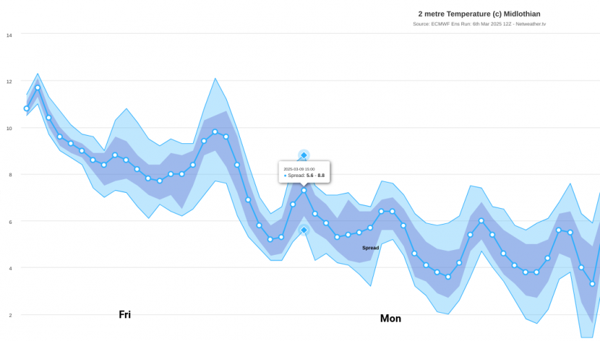
There is a similar story on the ECM model temperature plot further north. It is also turning colder. At the surface temperatures in Edinburgh could reach 14C, even 16C in any sunshine on Saturday. A noticeable change will occur during Sunday night. Remember that warm front to the north, that will return as a cold front with rain, sleet and mountain snow overnight.
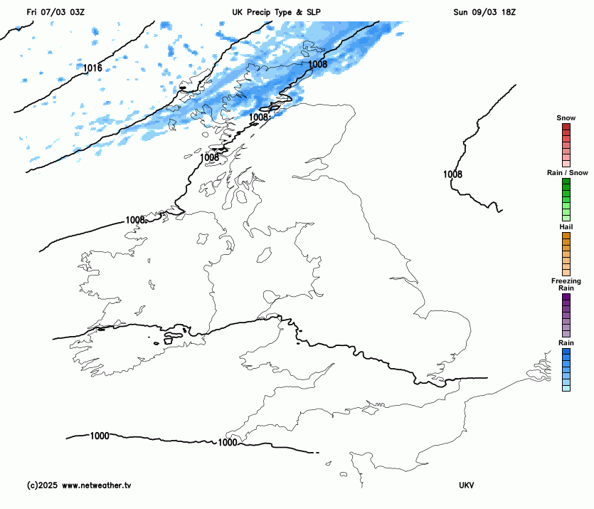
The cold air will take its time to work southwards early next week but as a low pressure rotates over the North Sea, this will throw precipitation towards eastern Scotland. In this, there will be wintry precipitation, especially for high ground. At lower levels it will just be the miserable icy rain. So this weekend don’t waste your time and energy putting stuff away in the loft or away under the bed. It’s far too early. A spring outfit might be okay for this weekend but you’ll need your coat again next week. And gardeners take heed of this upcoming change.
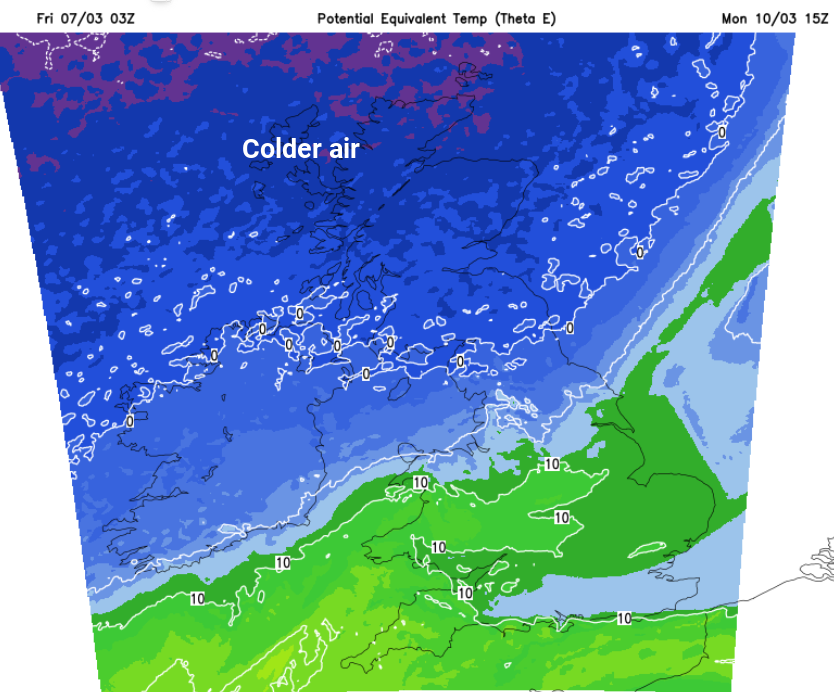
What's causing this shift to colder air?
Loading recent activity...