With yet more sunshine today, one has to go back almost fifty years to find a sunny start to March comparable to the present. The first four days across parts of central, southern England and the Midlands have so far recorded virtually continuous sunshine, and while there have been several fine starts to March in the past, only the first week of 1976 stands out as being almost as sunny. You may remember this was followed by a magnificent summer, but that doesn't mean that 2025 will follow suit.
We still have plenty more sunshine to enjoy into Wednesday afternoon over England and Wales, but this will be spoilt a little by thin high cloud, especially the further North you are. Here we've seen a lot of cloud this morning giving light rain or drizzle, but this will tend to break where, together with East Scotland, the sun will come through in places. Top temperatures 11 to 14C, with sheltered parts of the East and South and around the Moray Firth up to 15C, in a light or moderate South West or southerly wind.
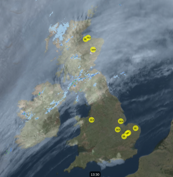 Image from the Netweather V8 Radar - satellite, radar and top ten temperatures.
Over the remainder of Scotland and Northern Ireland there'll be more cloud and a few showers in a fresh wind, with gales in the North West giving gusts up to 55 or 60mph in exposed areas. But here too it'll be mild, with temperatures about 11 to 13C.
After dark and closer to Atlantic systems, Northern Ireland, particularly towards Donegal, and mainly the North and West of Scotland will see a few heavier bursts of rain in a southerly wind that'll remain strong in the West. Across East Scotland and towards Down and Armagh it should stay largely dry with broken skies. But it continues mild, with the thermometer remaining between 10 and 12C in the North and West.
Meanwhile England and Wales remain fine and dry, and it shouldn't be as cold as on previous nights in somewhat more of a southerly breeze. Nevertheless, some sheltered rural parts of the East and South could still see temperatures falling low enough to give a touch of frost, with minimum values mostly in the range 1 to 4C.
Thursday brings yet another fine day, particularly for the East and South East, but with pressure leaking away, the West will be turning more unsettled. With winds in the South, it'll become rather warm in some sheltered eastern areas, where the thermometer could reach 16 or 17C. Over Scotland, bursts of rain in the North and West will move away, with the best of the sunshine in the East and South.
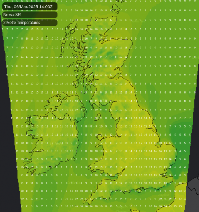
Although finer with some sunshine in the East, albeit probably rather hazy, the South West, Wales and later other parts of the West, together with Northern Ireland, will see showers developing. Some could be quite sharp, although not everywhere will catch one. Top temperatures 13 to 15C in a somewhat fresher southerly breeze.
After dark, the showers become more widespread over England, Wales and Northern Ireland, but some eastern areas may stay dry. The North and West of Scotland may also see further rain, with particularly Lothian and The Borders perhaps seeing fewer showers. But in a mild night, temperatures shouldn't fall below 5 to 10C.
Friday will be unsettled across a central swathe of the country. More showers are likely into the weekend towards the South West, but it'll remain mild with a few sunny intervals.
Loading recent activity...