England and Wales can finally welcome some sunshine, which will be well-timed for those on half-term holidays. Scotland and Northern Ireland start this week with more clouds, rain, and even a bit of snow, but the sun will appear by midweek. We’ve probably all had enough of this dullness and gloom. There are hints of spring now following the snowdrops, with a few crocuses and the green leaves of daffodils appearing now. We just need more sunshine.
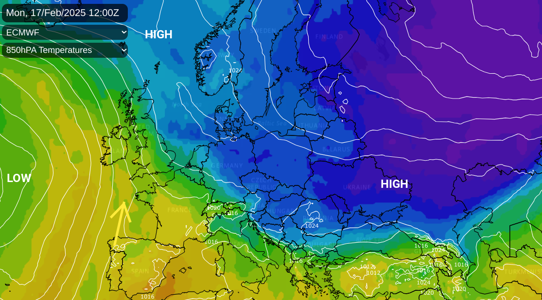
Deep cold has taken hold over Russia and many of the countries in eastern Europe have low temperature warnings with a hard frost and pockets of snow.
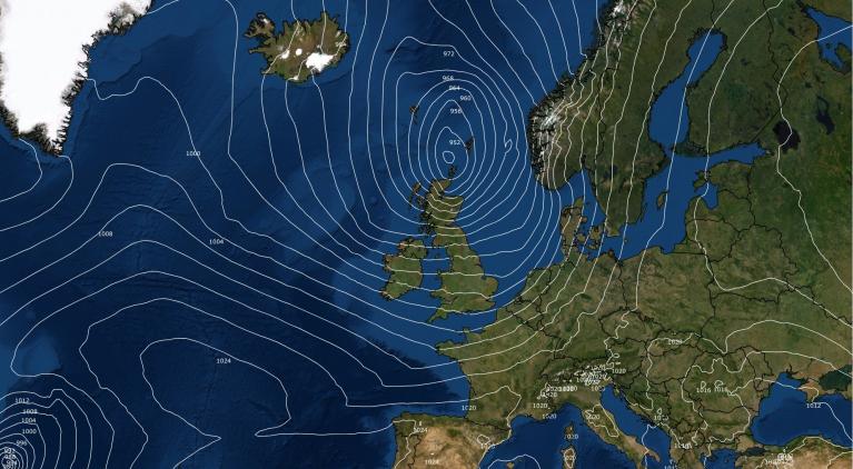
High pressure has anchored our UK weather, bringing steady conditions and the ongoing supply of gloomy grey cloud. It has also kept Atlantic low pressures at bay. There will be a shift this week. The southeasterly flow from the continent will gradually veer to a southerly allowing milder air over Ireland and SW Britain by Wednesday. Bristol could see 16C by Thursday after starting the week with an air temperature of 6C, but feeling more like 3C.
Through the week the influence of the Atlantic grows over the UK and western Europe. The weather becomes more windy, temperatures rise reaching double figures by day and we lose the risk of frost by night.
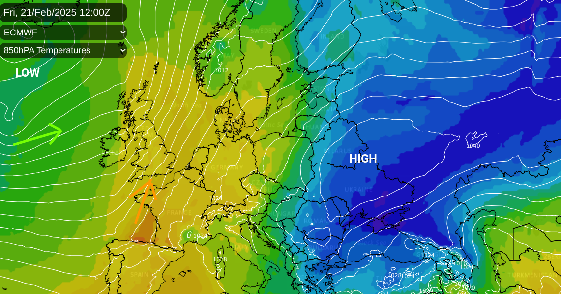
The temperature/pressure chart above shows the eastern cold diminishing and milder air from the south for the UK with plenty of isobars. Later this week does look windy, with gales for exposed coasts and hills by Friday. Sunday could see a deeper low pressure heading our way with wider strong winds and heavy rain which could be impactful. Just something to keep an eye on if you are travelling at the weekend. Although it is a fair way off at the moment.

Monday to Wednesday
At the beginning of the week, we have weak weather fronts from the west hitting the ongoing cold air and fading as the eastern high pressure continues to act as a shield. There has been a bit of snow over the high routes of southern Scotland on Monday morning with passing flurries and dampness elsewhere. For most, it is a cool feeling day in a light southeasterly wind with temperatures around 4 to 6C. Inland there will be a patchy frost by night with lighter winds. Outbreaks of frontal rain will reach Northern Ireland on Monday night and there is a Met Office snow and ice warning for parts of Scotland on Tuesday.
“Snow and freezing rain may make for difficult driving conditions, especially over higher routes.”
This is to highlight potentially tricky conditions inland with a few cms for higher level routes and patchy slushy deposits for a time at lower levels. However, it is the risk of freezing rain, which leads to sudden black ice “even on treated roads” that needs watching. The wintry conditions should improve in the afternoon.
Much of England and Wales should have a fair day with bright skies.
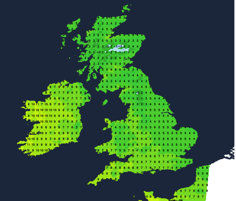
Atlantic low pressures will be forced northwards towards Iceland at the start of the week but a trailing cold front will progress across Ireland before dawn on Wednesday then bring rain over Northern Ireland, western Wales and SW England during the morning. Ahead of this another fair day with bright spells and a milder feel midweek as temperatures reach 6 to 10C, perhaps even up to 13C.
The outlook
The cold front fades and any rain becomes more patchy as it continues eastwards but another Atlantic system follows for Wednesday night. The winds freshen as they veer to the south and southwest with heavier, more showery rain for Thursday. Friday will start off windy with gales for western coasts but the winds will ease by Friday evening. Southeastern Britain will escape most of the rain this week so a brighter and milder week for London and the Home Counties, up to around 15C by Friday.
The wet and windy Atlantic flow looks set to continue into the following week so expect changeable conditions if your half-term holiday is even later in February.
Loading recent activity...