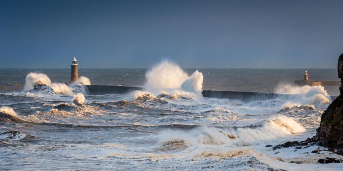
As Ireland & northern UK clear up after Storm Eowyn, gales return in the west on Sunday with the arrival of Storm Herminia (named by the Spanish). The storm will also bring heavy rain, with further heavy rain possible on Wednesday too.
The impact of Storm Eowyn continues to be felt across Ireland and northern Britain. Thousands of customers are still without power across the island of Ireland, with a big clean-up effort underway now the winds have eased following damage to buildings and blocked roads from fallen trees. Also, over 100,000 people are without water, following power outages at treatment plants and pumping stations. The fastest gust of wind ever recorded in Ireland was measured at Mace Head, with a gust of 114mph recorded at 5am. It was also the first time red weather warnings covered the whole of the island of Ireland.
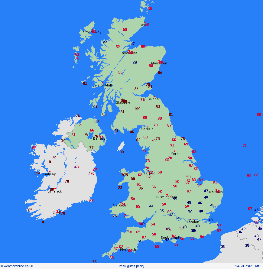
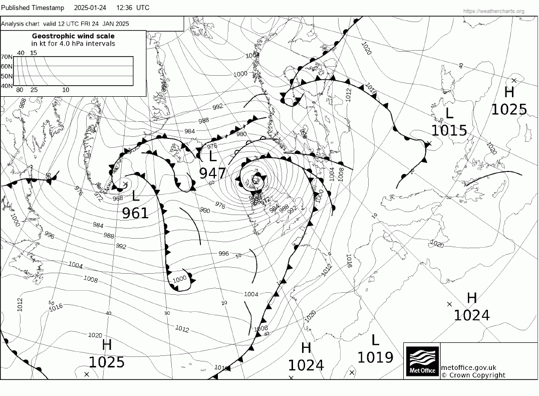
The storm then moved on to Scotland in the afternoon, bringing a peak gust of 100mph at Drumalbin in the south of the country. Over 100,000 in Scotland, and 20,000 in NW England were without power overnight. There is still disruption to travel across the north of Britain, as the clear up continues, though the east coast mainline between Edinburgh and Newcastle has re-opened, but there are still no trains north of Preston on the west coast mainline.
Thankfully a calmer respite on Saturday for all of the UK, with most places dry and bright or sunny with lighter winds, just a few wintry showers in the northwest. However, there are more warnings in force for Sunday for wind and rain, as the next low pressure system developing out over the North Atlantic arrives to the west of Ireland, bringing further wind and rain.
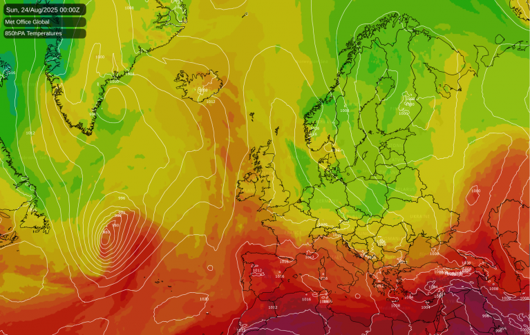
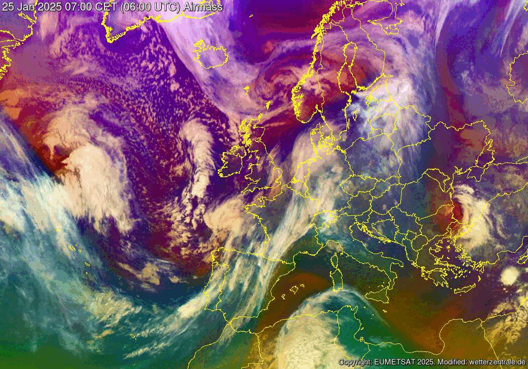
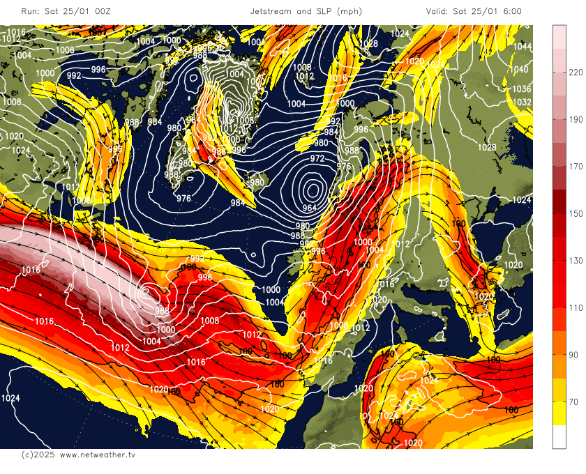
This next system has already been named by Borrasca (Storm) Herminia by the Spanish Met Service AEMET for very strong wind gusts, locally even hurricane-force winds in the northwest of Spain, waves greater than 7 meters on the northern coasts and heavy rains in Galicia. The low is now deepening on the polar side and developmental left exit of the jet stream over the mid-North Atlantic, the jet seen as the colour demarcation between warmer Tropical maritime air (blues) and colder Polar maritime air (purples) on the airmass imagery below.
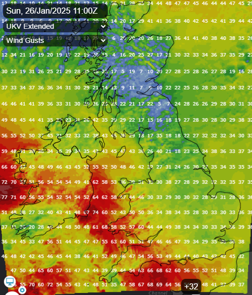
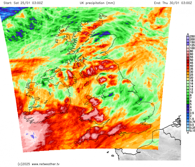
Although the wind won’t be as strong as produced by Storm Eowyn across the UK, winds could still gust to 60-70mph across the west and southwest for a time. The rain will be more of an issue this time though, with up to 80mm falling across parts of Wales and SW England by Monday morning. An occluding frontal system will bring a band of heavy rain accompanied by strong winds northeast on Sunday, winds gusting to 60-70mph around coasts across Ireland, SW England and Wales, 50-60mph elsewhere around coasts, locally 40-50mph inland. Winds easing following clearance of the rain, but remaining windy in the far west. Not great news for Ireland, where the clean-up continues following Storm Eowyn. Following Sunday evening, a frontal wave moving in from the southwest looks to bring a spell of heavy rain northeast across southern, central and eastern England.
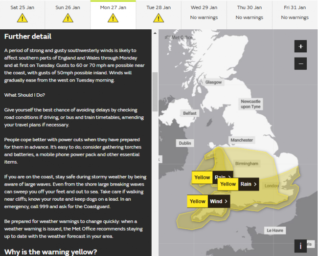
As the deep Storm Herminia low crosses Ireland on Monday, with central pressure around 955 hPa, strong southwesterly winds look to develop across southern England for a time, with a new Met Office warning issued for here, with gusts of 60-70mph possible along southern coasts, 50mph inland.
The Met Office have issued yellow warnings for winds and rain for southern and western areas of the UK for Sunday and Monday, :

Herminia will then slow down and fill as it crosses northeast across Ireland and the UK early next week, with showers and brisk winds circulating around it. Then by Wednesday, some uncertainty over track, another low pressure system developing to the southwest of Ireland Tuesday night looks like it may move in across southern England, bringing a spell of heavy rain, with this further rain increasing the risk of flooding. However, the low may end up tracking further south in the end, with less or no rain.
Potentially high rainfall totals across Wales and SW England by Thursday
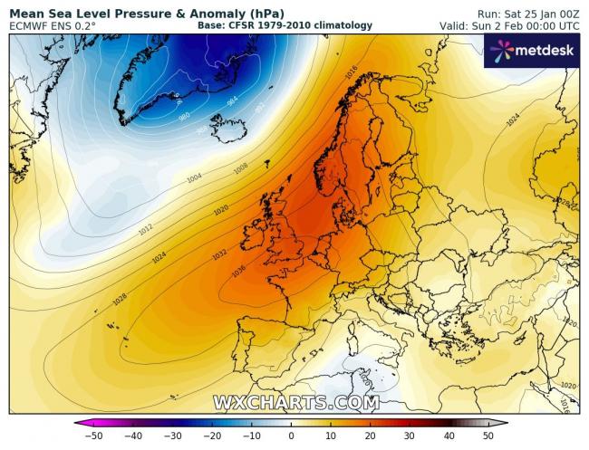
The good news is, the current spell of very disturbed and unsettled weather looks to come to an end by next weekend, perhaps by Friday, as high pressure builds in and, as it looks to be a blocking high, it could stay dry and settled into the following week too, though the far north may stay unsettled, with Atlantic low pressure systems passing to the north bringing rain and wind at times here.
Loading recent activity...