Although milder recently, particularly in the North West, high pressure has dominated much of the country for a while now. When this happens it's not uncommon for colder air to return, with the current drop in temperature over England and Wales a result of continental air moving North from France. Temperatures there are hovering around freezing, but fortunately for us, France, like the remainder of western Europe, isn't particularly cold at the moment for mid-winter. But nevertheless much of England and East Wales will still feel the chill, in another cold, raw day.
Sunday will be similar to Saturday, as the dry, quite spell continues across much of the country. The new working week will also begin much the same, but as pressure leaks away, it'll be turning more unsettled and gradually milder from the South and West mid-week in what has been a cold January so far. Later in the week, a complete change to windy, even stormy weather is possible.
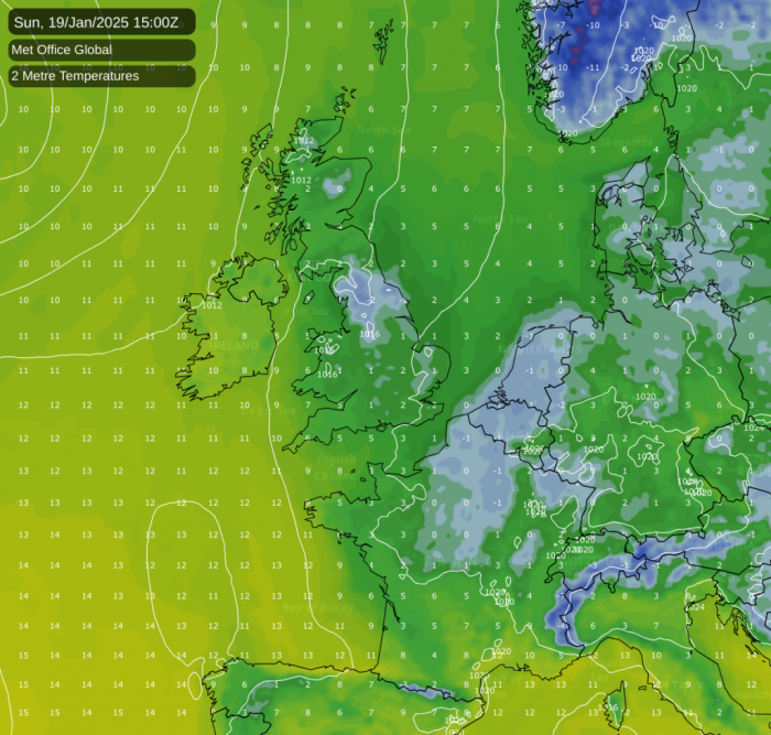
For Sunday afternoon, although mostly dry, much of England and Wales continue under a sheet of low stratoform cloud. This'll make it misty over hills, perhaps with a little drizzle here and there, while others may be lucky enough to see some brightness - a glimpse of the sun. But the best of the sunshine will be over Scotland and in the North and West, making it quite pleasant for a while. Northern Ireland will be similar, although here, you may see a few showers moving into the West towards dusk.
A mostly light southerly breeze will be fresher in the West, where you'll also see the mildest temperatures. You could reach double figures over sheltered parts of Northern Ireland and the Western Isles. But where you keep the 'gloom' and more especially in the East where around Grantham the thermometer struggled to get above freezing yesterday, a cold 2 to 4C is more likely.
Northern Ireland and the North and West of Scotland see some mostly light rain after dark, but for most it continues dry. Where you keep clear skies there'll be a slight frost and some patchy locally freezing fog as temperatures fall to zero to -2C. But where you keep cloud you'll avoid a frost, although it'll turn misty fairly generally in a mainly light southerly breeze.
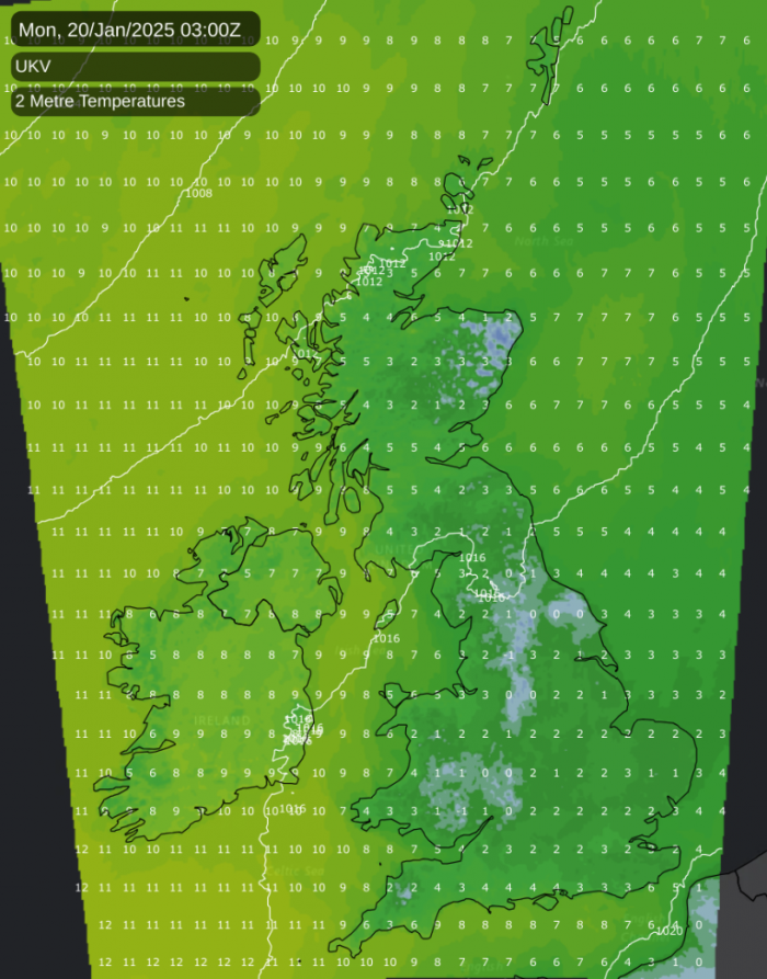
A weak front may give a few showers towards the Scottish border at first and across the North and West of England and Wales later, otherwise the new working week begins dry. Scotland and Northern Ireland, apart from a few showers in the North, should be fine, with a better chance on Monday of seeing some winter sunshine over England and Wales once patchy frost and fog has cleared. Although breezier in the far North, winds remain mostly light from a southerly quarter, with top temperatures about 5 to 8C making it a little less cold over parts of eastern England.
After dark, that weak front now across central parts, gives further patchy light rain or drizzle, but to the North and South of the front skies will be more broken. Clear intervals allow mist, patchy fog and maybe a touch of frost to form again in mostly light winds although cloud amounts will vary. Lowest temperatures about zero to +5C.
Further ahead, it's set to be a mostly cloudy and damp week across the UK, with some brighter spells in the north and west. The weather will become more unsettled towards the end of the week and into the weekend with an increased chance of rain and strong winds.
Loading recent activity...