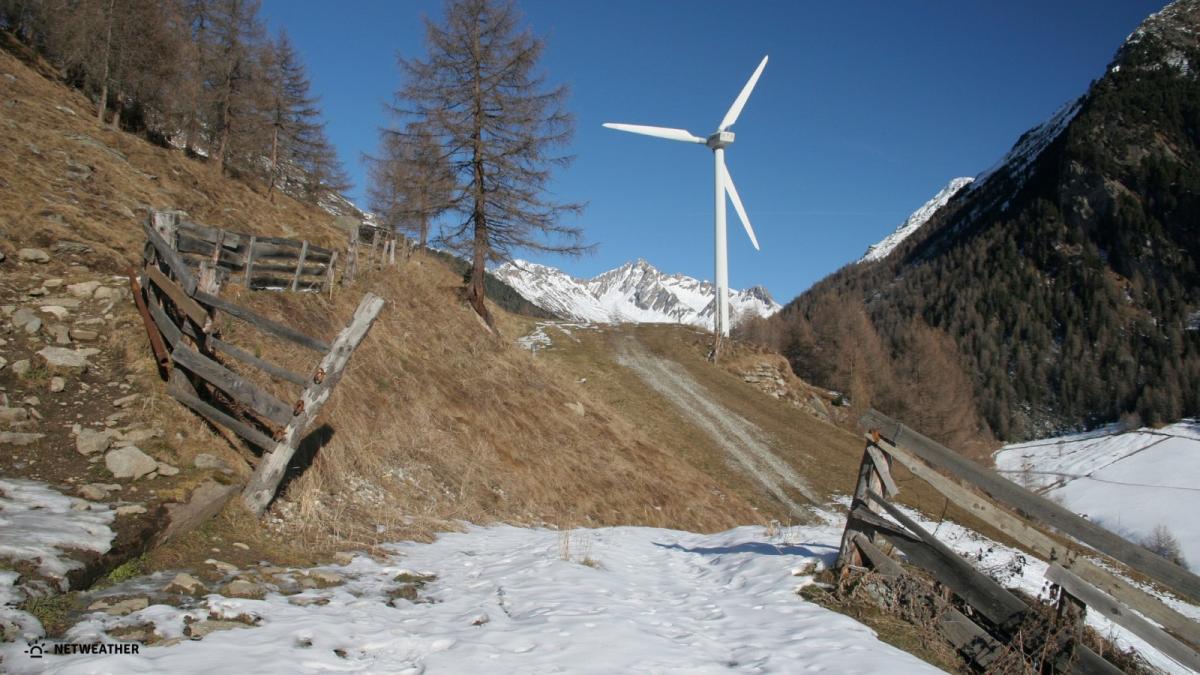
Helm Wind (Cumbria, England)
The Helm Wind of Cross Fell, in the Cumbrian North Pennines, is England's only named wind. The wind is shaped by the unique geography found at Cross Fell, the highest point in the Pennines at 893m, so the Helm is a true local wind, and a phenomenon that has come to assume great cultural as well as environmental significance in the area.
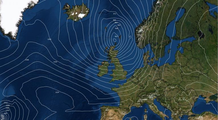
The Helm Wind is a strong, cold, north-easterly wind that occasionally blows down the western slope of the Cross Fell range of the Northern Pennines into the Vale of Eden in north-west England. It occurs when the horizontal component of airflow is virtually perpendicular to the hills, which restricts directions to the north-east, and when a stable layer of air lies about 600 m above the summit of the range.
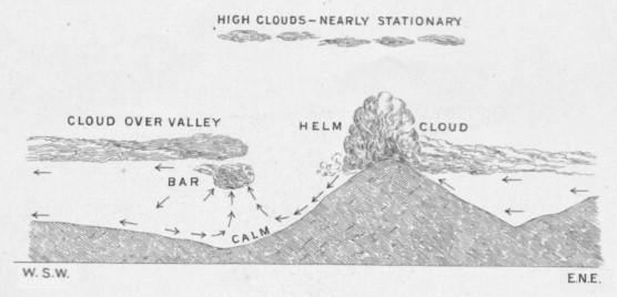 Image from National Meteorological Archive, Exeter.
 Helm wind bar over the northern Pennines - image courtesy of Osbourne One-Nil (Netweather)
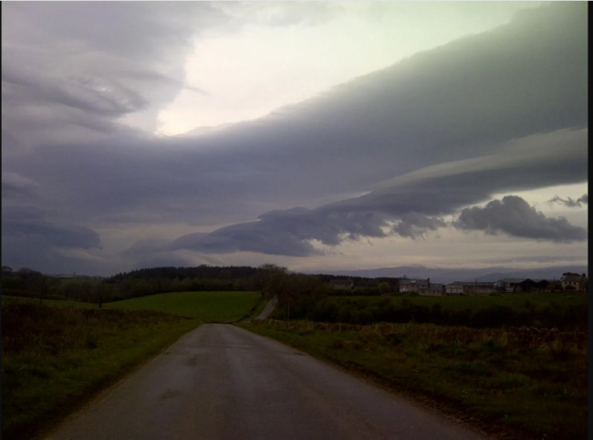
When the Helm Wind blows, a heavy bank of cloud (the ‘Helm’ or ‘Helm Cloud’) rests along the Cross Fell Range, whilst, three or four miles from the foot of the Fell, a signature cigar-shaped, rolling cloud (the ‘Helm Bar’), forms and remains stationary over the mountain tops. The Helm probably takes its name from the Anglo-Saxon, signifying a helmet or covering for the head, and is a reference to this distinctive cloud formation. The wind is similar to a ‘Foehn’ type wind, typically dry and acting down slope in the lee or downwind side of a mountain range. The wind is powerful enough to knock over walkers and can last for days.
Mistral (southern France)
Mistral is a cold, northerly or northwesterly wind flowing down the Rhône Valley in France and out over the coastal areas of the Mediterranean Sea and out over the Mediterranean Gulf of Lion from the southern coast of France. Sustained winds often exceed 40 knots and gusts sometimes reach 100 knots over the Gulf of Lion, however, its effects often extend past Sicily into the eastern portion of the Mediterranean basin. Wave heights associated with the mistral commonly reach 4.5-6.0 m, but have sometimes reached a maximum height of about 9 m.
Classic set-up for Mistral wind to blow, image courtest of Windy.app
The mistral is most common in winter and in spring, with the strongest episodes tending to occur in the transition between those two seasons. The wind can last several days, or even more than a week. It has been reported to exceed 30 kt for over 65 hours at some locations. Although gale-force events can occur year-round.
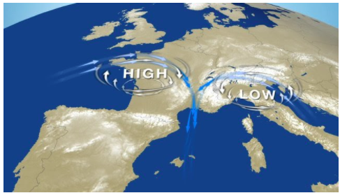
Its appearance is linked to the joint presence of an anticyclone extending from Spain to the southwest across the Bay of Biscay, and a depression in the vicinity of the Gulf of Genoa off NW Italy.
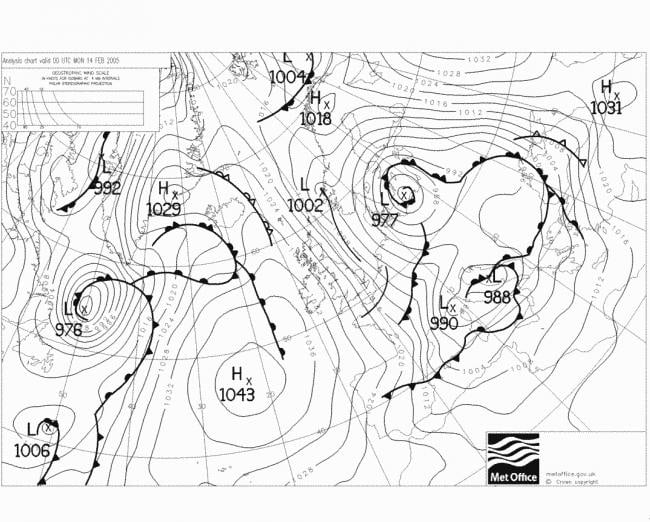 Synoptic setup that brought a Mistral wind on 14 February 2005
The area of influence of the mistral is linked to the positioning of this depression: when the depression is located north of the Gulf of Genoa, the mistral also affects the Côte d'Azur. The most favourable situation for the appearance of the mistral is that which follows the passage of a rainy cold front which reaches the Mediterranean after having swept across the whole of France from the northwest to the southeast.
Despite its ferocity, the mistral generally brings clear skies with good visibility and offers spectacular views of the Provençal landscapes. It cleans the air of pollution too.
Levante wind (Eastern Spain)
The Levante wind blows from the east and affects the coasts of the western Mediterranean, though it is in Spain where it appears with greater profusion and force and where it greatly affects days at the beach, water sports or sailings at sea.
This wind is often accentuated by the profile of the Iberian Peninsula, which forms a kind of tunnel or mouth between the province of Cadiz and the Strait of Gibraltar with the north of Africa in Morocco. Through this narrowing gap between Spain and Morrocco, the easterly wind increases in speed as it is funnelled through the reduced space.
In some areas of the western Mediterranean, the Levante wind is often accompanied by fog and rain, especially over the Rock of Gibraltar, however, in other areas, the wind causes a dry climate, such as on the Andalusian Atlantic coast.
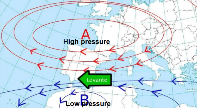
In Gibraltar the clouds that form over the Rock are known as the beards of the Levante, while on the beaches of the Cadiz and Huelva coasts further west, the wind causes the sand to blow in from the beach while the heat also increases. This wind occurs throughout the year, but its peak period is from May to October. It tends to form when high pressure from the Azores extends east across western Europe, with low pressure to the southwest of Spain or over Morocco.
Bora wind (Eastern Adriatic coast)
The Bora is a strong, dry, cold wind from the northeast that affects around 500 miles of the eastern Adriatic coastline from Trieste in Italy to Albania, including the countries of Slovenia, Croatia, Bosnia and Montenegro. It forms when cold air is bottled-up behind the Karst Plateau inland from the coast in these countries and the continental side of the mountains which run along the eastern Adriatic coast.
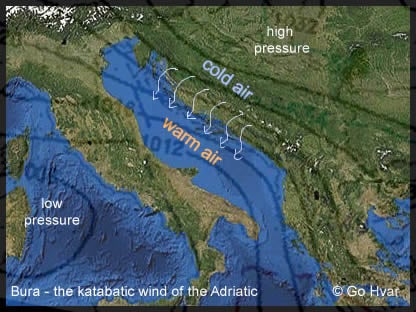
When air pressure is high enough inland across the continental interior of the Balkans, the cold air bottled up inland is pulled with great violence through a handful of passes and cols in the mountains along the coast as the atmosphere tries to equalise with lower pressure over the warmer Adriatic Sea.
The Bora wind can reach hurricane-strength – sinking ships at sea, ripping roofs off houses, blow over lorries, uproot trees, close high bridges and exposed roads or motorways, even blow fish out the sea.
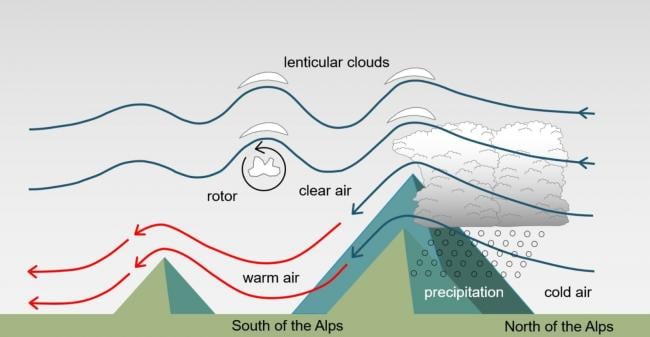
Foehn/Fohn (Alps)
Generally occurs when winter turns to spring in the Alpine Valleys. It is a warm, dry katabatic wind – which means the wind blows downslope from the higher parts of the Alps. An anabatic wind is the opposite, blowing upslope. Other ‘foehn-type’ winds include the Chinook wind of the Rocky Mountains of Canada and USA, the Santa Ana wind in California and the Halny wind of the Carpathian mountains in the south of Poland.
 The Foehn wind in the Alps, image courtesy of Open Snow
The strong, warm and dry Foehn wind contributes to wildfires of the forests that carpet the Alpine slopes. It is also attributed to causing migraines, anxiety, depression and even insanity. The upside is that it brings clear skies and warmth at the end of winter – which can be grey and cold for lengthy periods.
In Switzerland, there are 2 types of foehn wind. The North Foehn blows from the north down the southern slopes of Italian-speaking part in the south of the country. The South Foehn blows from the south down the northern slopes of the Alps into the German-speaking north of the country. The wind is formed by the rain shadow created by the Alps, so in the lee or rain shadow of the mountain it is dry and warm but windy, while the other side of the Alps it is cloudy and wet. Because moisture is shed the other side of the Alps, as the wind descends the slopes it is dry but also warms up – causing temperatures to rise.
Sirocco wind (Mediterranean)
Sirocco is a strong to gale force wind blowing between southeast to southwest and originating as hot, dry desert-air from the Sahara of Northern Africa. The wind can subsequently become humid as well as hot where it has greatest fetch over the Mediterranean Sea on arrival along northern Mediterranean bordering coasts. With a short fetch over the sea on arrival, it tends to remain dry and hot.
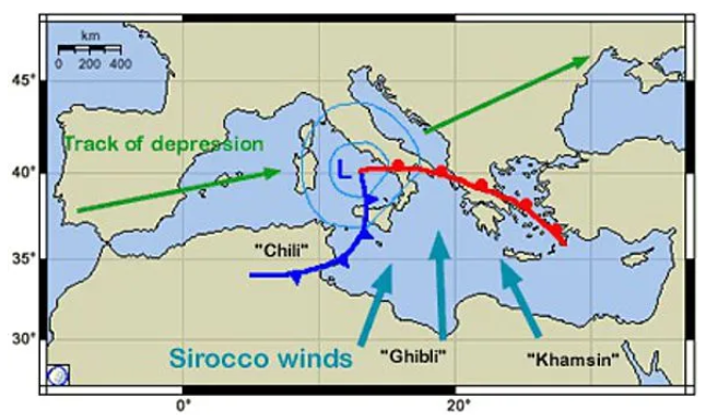 Image courtesy of Accuweather
Along the north African coast - the Sirocco produces hot, dry and dusty conditions. Visibility becomes very poor and the fine blowing dust can cause damage to instruments and equipment. As the air travels northward across the Mediterranean Sea, the Sirocco picks up moisture and causes low stratus cloud, fog and rain over northern Mediterranean areas. The sweltering, sultry and close weather during a Sirocco event causes headaches and insomnia for many. The hot humid wind causes overnight temperatures of 30°C and above, while thermometers may well reach 40°C during daytime.
Sirocco wind events can occur all year round, but most commonly occur during Spring. The average duration of continuous gale force winds during a Scirocco is 10 to 12 hours and occasionally as long as 36 hours. The Sirocco often occurs as a surface low moves eastwards over the southern Mediterranean combined with the passage of a deep upper trough extending well into north Africa and positioned west of Tunisia.
Loading recent activity...