Storm Darragh has brought significant disruption to parts of Britain, with Wales bearing the brunt of its impact. As the system moves eastward, we examine its development, current effects, and the notably different weather pattern set to follow.
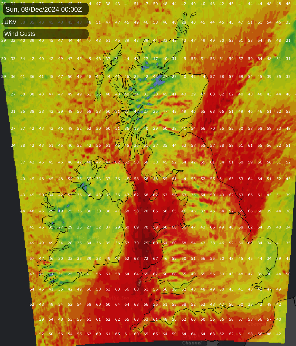
Storm Darragh has been with us today, and has already caused considerable impacts. At the time of writing, a gust of 93mph had been recorded in Wales, with an estimated 35,000 people (and rising) without power. Rail services have been affected, such as at Bristol Temple Meads, where many services are delayed or cancelled. Cardiff Airport has closed its runway and some coach services are affected. It is also anticipated that some English Premier League football matches will be postponed.
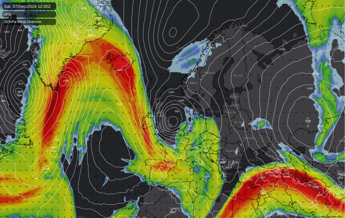
This storm had been showing on the forecast models for several days beforehand, but there had been considerable uncertainty over its path and severity. Some model runs had the system moving eastwards across the English Channel and sending disruptive winds into France, while others had the system more or less accurately placed.
There was also some uncertainty over where the strongest winds would be. Some model runs had previously shown the strongest winds in North Sea areas, with synoptic charts showing that resembled the ones associated with the exceptional North Sea floods of 31 January/1 February 1953. However, it was never likely to result in anywhere near as extreme conditions in the North Sea, because the 1953 event had the depression initially off the coast of north-east Scotland and then tracking south-eastwards through the North Sea, introducing a long fetch of gale to storm force northerly winds through the North Sea for a longer period. Today’s depression was always forecast to approach the North Sea from further south.
As we got close to the time it became clear that the strongest winds would be through the Irish Sea and into Wales, which is why the Met Office covered those areas with a rare red weather warning. So far those areas have seen the largest impacts, but while other regions are expected to be less affected, central and eastern parts of Britain will see the winds pick up later on Saturday as the depression moves out into the North Sea.
This system is not forecast to produce or be followed by widespread snow at low levels, despite two or three days of northerly and north-easterly winds. There are various reasons for this. The low pressure system associated with today’s strong winds has quite a warm core, which will mix with the colder Arctic air coming south and reduce its intensity. Also, our side of the Arctic is not currently particularly cold, having recently had another depression introduce relatively mild air into the region, and so the Arctic air that is coming south is thus not especially cold. In addition to this, Scandinavia will see some relatively mild air rotating around Storm Darragh and this will enter our circulation early next week. It will still be a little colder than average going into early next week, but not cold enough for snow on low ground.
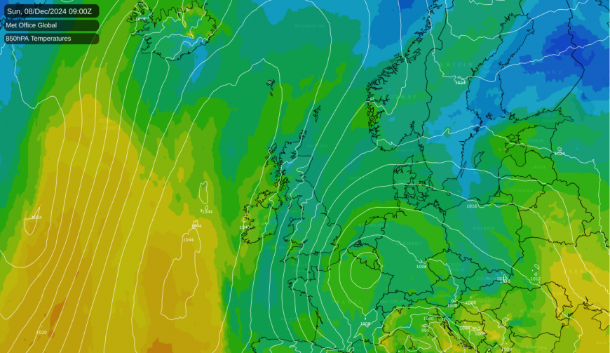
The remarkable cold spell that we had in the third week of November was very different: a large scoop of cold air came right down from near the North Pole, and we ended up with an air mass sourced from all the way up in the high Russian Arctic. Although the Arctic had started off anomalously warm at the start of November, it had cooled down in the second week, and the region to the north of Britain had seen northerly winds for a few days prior to the northerly blast hitting the British Isles. As a result, we picked up a northerly airstream which had very little mixing with relatively warm cores of low pressure systems, and ended up with our most substantial November wintry spell since late November 2010.
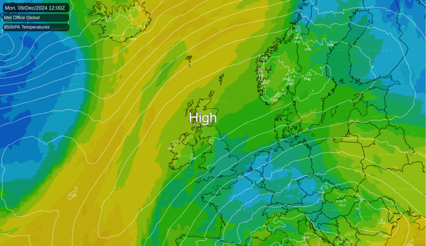
In contrast to today’s strong winds, the upcoming week is forecast to be quiet once the northerly fizzles out, by Monday in the north and by Tuesday in the south-east. In Scotland, Northern Ireland and northern England, high pressure will be overhead for much of the week, resulting initially in dry sunny weather by day and cold frosty nights with some fog patches. It may turn cloudier later in the week in areas where low cloud forms overnight and does not shift quickly during the daytime, but certainly early to midweek these regions can expect plenty of sunshine.
Further south, easterly winds are forecast to prevail for much of the week. Initially these will bring sunny spells with some scattered showers mainly near North Sea coasts, but it may turn cloudier into Tuesday and Wednesday as a more stable air mass moves in. Much of Wales and the West Country will be sheltered and thus can expect to hold onto a fair amount of sunshine. Frost will not be widespread in the south due to more wind and cloud cover.
Loading recent activity...