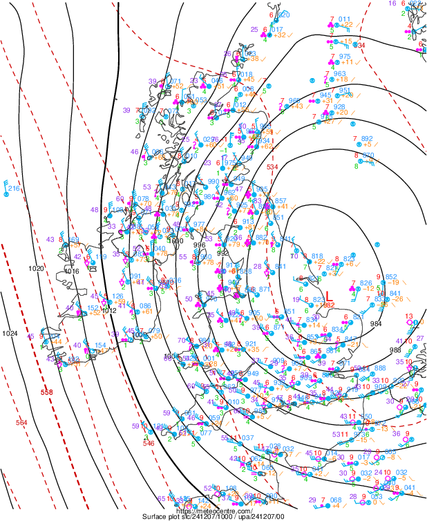
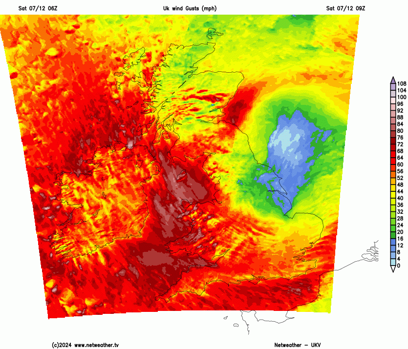
Storm Darragh's centre is moving off eastern England into the North Sea with very strong winds on its western side, with gusts reaching 93mph in west Wales this morning. Strong winds and heavy rain transferring east through the day.
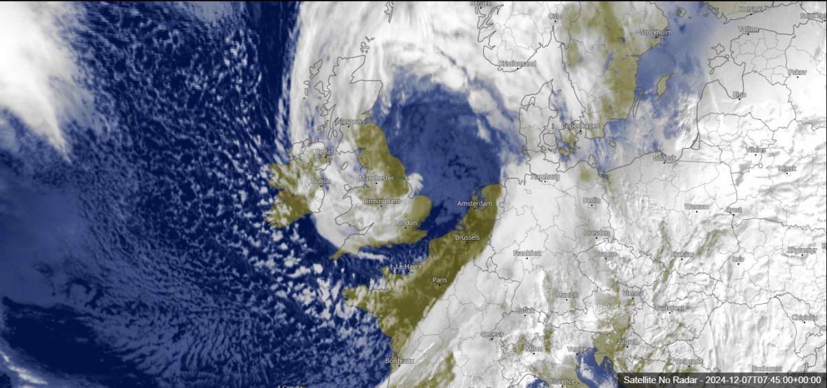
The centre of Storm Darragh is just off eastern England late this morning and will move out into the North Sea by early afternoon, before turning more in a southeastward track towards the Netherlands later today. The strongest winds have been on the western and southwestern side of the low as it’s moved east from N. Ireland to northern England overnight.
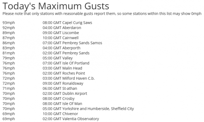
Peak gusts so far today are below, with west Wales under the Met Office red warning bearing the brunt of the strongest winds, with latest gusts of 93mph at Capel Curig and the top 20 gusts so far today below.
The satellite image above the article shows a scorpion-like tail of Storm Darragh crossing east across the UK. There’s certainly a sting in the tail too, with a nasty combination of heavy rain and gales or severe gale westerly veering northwesterly winds on the western side of the low moving across Wales and England this morning.
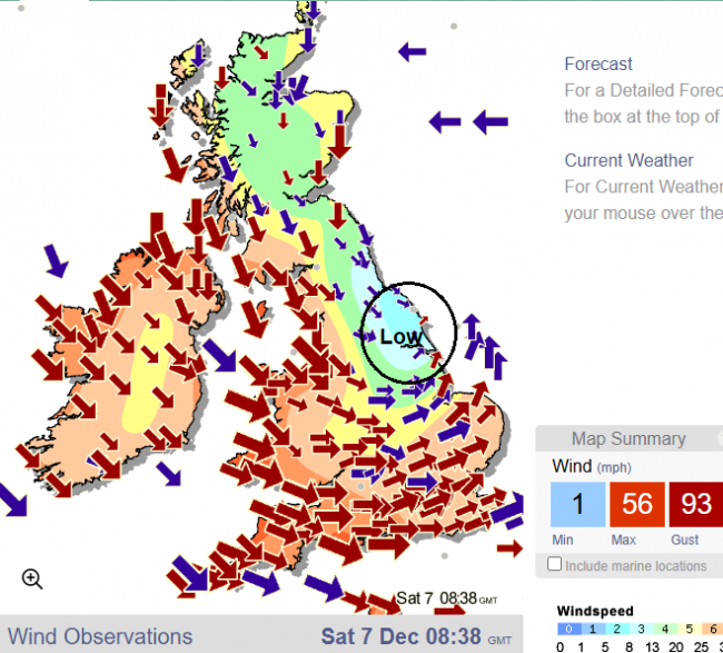
Gale to severe gale force winds will be sustained across west Wales and SW England throughout the day, with gusts of 70-80mph around coasts and over hills, 50-70mph gusts inland. Such prolonged strong winds are quite unusual when wind storm events occur, as normally there will be 3-4 hours of severe winds before they subside.
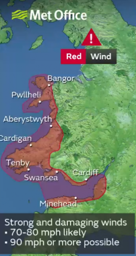
So really is a day to stay indoors across Wales and SW England in particular, with danger from falling trees or flying debris along with widespread travel disruption The sustained very strong winds weakening structures, causing damage to them, with a risk of flying or fallen debris on roads and railways along with whole or parts of trees falling down. The sustained strong winds and wet ground from recent and current rain likely to weaken some trees which will increase the chances of them toppling over.
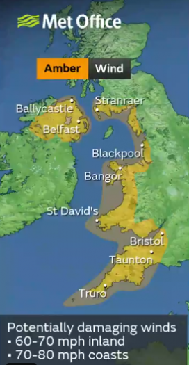
A danger to life red wind warning across west and south Wales along with SW England bordering the Bristol Channel is in force until 11am. This will be superceded by an amber wind warning for 70-80mph gusts across N. Ireland, SW England, south and west Wales, parts of NW England and SW Scotland until 9pm.
There is widespread travel disruption towards the west in particular, with both the M4 and M48 bridges over the River Severn closed in and out of Wales. Meanwhile train services in the west have been cancelled or are being severely delayed due to fallen trees and debris on the lines. Railway lines through much of SW England and parts of Wales have been closed, with Great Western Railways and Transport for Wales cancelling many services. National Express coach services to Wales and SW England are cancelled or severely disrupted.
Cardiff airport is closed, while Bristol and Liverpool airports are seeing delays to flights.
Over 60,000 customers are without power too, this includes: over 35,000 across Wales; 20,000 premises in the south-west; around 5,000 premises in the West Midlands; 300 in the East Midlands.
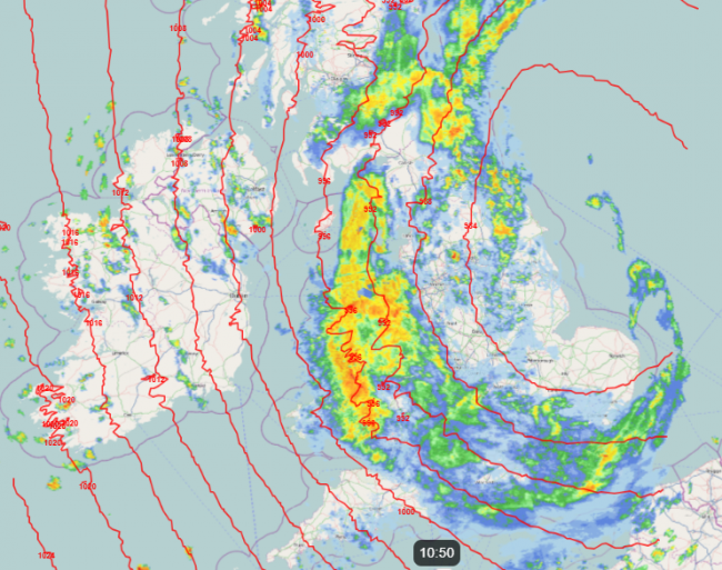
There is also an Amber Warning for rain in force across south Wales until 6pm - where up to 80-90mm of rain may fall. This area has seen recent flooding, especially from Storm Bert, so is susceptible to more flooding with any heavy rainfall today. It’s been very wet here this morning and as the radar below shows, more moderate to heavy rain for the next few hours at least.
Strong winds and heavy rain will transfer towards the east through this afternoon, evening and overnight, with a yellow wind warning in force further east across England for gusts of 50-60mph inland, 60-70mph along coasts.This may cause some disruption too.
Strong winds will slowly ease across the west tonight, but gales continuing towards the east, with the rain relentless towards eastern England off the North Sea as the Storm Darragh low moves away into the Netherlands overnight.
Loading recent activity...