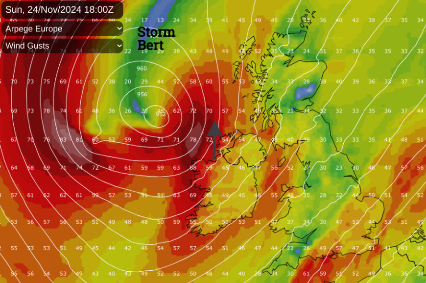
Storm Bert will bring high winds, heavy rain, sleet and snow with the risk of surface water flooding. With poor travel conditions, Saturday morning looks particularly grim.
Storm Bert will dominate Saturday’s weather with warnings for strong winds, heavy rain and flooding along with snow and ice. With travel disruption likely it might be a day for staying indoors but if the pull of Christmas shopping or a Christmas market is too strong, here’s a look at the weather timetable of Bert around the UK.
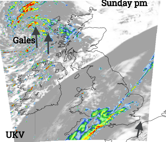
This event will bring a significant change for our UK weather. Severe weather is expected so do keep an eye on the forecast and the Met Office warnings. Sitting in a traffic jam due to flooding or issues from blowing snow over higher routes isn’t a fun way to spend a Saturday. The high winds could cause restrictions on bridges or exposed routes, and cause delays to rail services and ferry services. It could be worth delaying plans, even until Sunday as some areas will see an improvement to a bright and blustery day. Showery rain and gusty winds will continue to affect southern Britain on Sunday as another bout of strong winds, even gales hits the far Northwest for the end of the weekend.
Snow will turn to rain in many areas but as it falls with strong gusty winds, conditions will be poor then slushy.
Northern Ireland, Scotland, Northern England and the Midlands
Belfast
It will be stormy during the early hours of Saturday around the coasts but the gales will ease during Saturday morning. Northern Ireland will see heavy rain mixed with sleet and snow starting before dawn but clearing towards lunchtime. Any lying snow won’t last as heavier rain takes hold and there is the risk of surface water flooding. With a strong and gusty SE wind, it will feel cold in the wind and rain until the main frontal band clears towards Britain. A mild southwesterly flow will then take hold and temperatures will rise as we finally lose the cold Arctic air and air from the Atlantic arrives. County Down will hold onto a good deal of cloud but temperatures will rise to 13C, quite a change from Friday’s maximum of 4C.
Saturday afternoon will be much better than the morning.
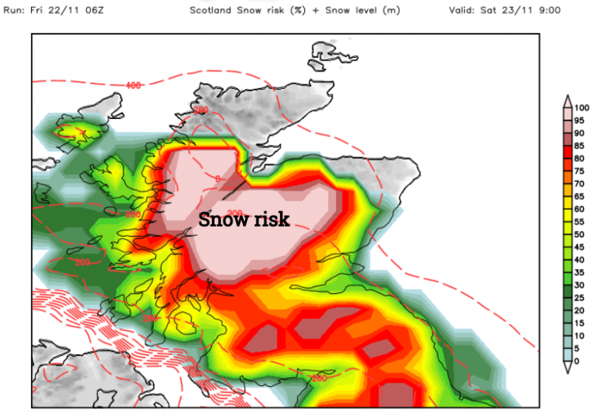
Widespread warnings for Saturday over Scotland with wintry and windy conditions
Edinburgh
Eastern and NE Scotland will have a cold Friday evening. Rain and snow will reach Glasgow before dawn and spread across the Central Belt to Edinburgh for a foul morning. There will be heavy rain, sleet and snow with strong, gusty SE winds. It will feel cold with wild conditions around the coast and mountains of Scotland. For Edinburgh after a wet and wintry morning, there could be a cloudy lull at lunchtime but there is a risk of further rain during the day. The winds will ease off during the afternoon but it will remain cold and damp.
There is already an amber warning for Snow & Ice for central Scotland with moderate impacts forecast from the heavy snowfall of Storm Bert. Travel in this region will be difficult and more widely due to the strong winds and heavy rainfall, especially in western Scotland
Saturday evening looks much improved for Edinburgh as the winds ease and the rainband clears away to Orkney and off over the North Sea.
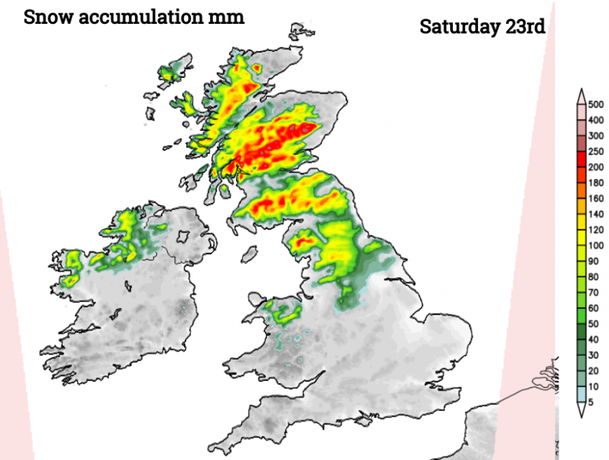
Amber warning Saturday morning inland, upland northern England and Southern Uplands "10-20 cm on ground typically above 200m, and potentially as much as 20-30 cm on hills above 400m. Snow will eventually change to rain in all areas by Saturday afternoon, but may be preceded by a short spell of freezing rain in places adding to the ice risk. Strengthening winds will lead to drifting of lying snow" MO
Manchester
Although there aren’t weather warnings for Manchester or Merseyside there are Rain, or Rain & Snow warnings in surrounding areas and disruption to travel is still possible for incoming road and rail routes. It will be cold and wet first thing with a fresh, gusty SE wind. As the winds veer to the S or SW there could be some shelter from the rain by mid-morning, leading to a cloudy but milder picture. From lunchtime onwards, it won’t feel as cold and the rain should ease off with lighter winds by Saturday evening. Temperatures will reach 12C by teatime so quite a change. A better end to the day

Sunday in the north
Belfast, Edinburgh and Manchester all look bright and blustery for Sunday. Temperatures will be several degrees higher and we will have lost the Arctic chill. As the low centre nears western Scotland on Sunday afternoon there could be wild conditions again for Northern Ireland and western Scotland so the window for ferry travel will be short as southerly gales (or even stronger) return.
Southern England, Wales, and East Anglia
Cardiff
Rain will set in during Friday night as the southerly winds freshen. With heavy and persistent rain into Saturday, there are concerns about surface water flooding which could cause travel disruption. Snow disruption is not likely for Wales on Saturday, although conditions for Eryri Snowdonia National Park will be difficult with pre-dawn snow turning to torrential rain with gales and storm-force gusts through the morning.
The Met Office says “There is a chance that prolonged heavy rain could become slow-moving over south Wales with up to 150 mm possible in a few places”. It will remain a blustery day although the air will be much milder later on, up to 14C in Cardiff, as the flow veers to a southwesterly. The main concern is the amount of rain from Storm Bert and there will be rough conditions around the coasts and there are concerns for English Channel coasts too.
“Strong winds due to Storm Bert likely to cause dangerous coastal conditions and disruption across southern England.” MO
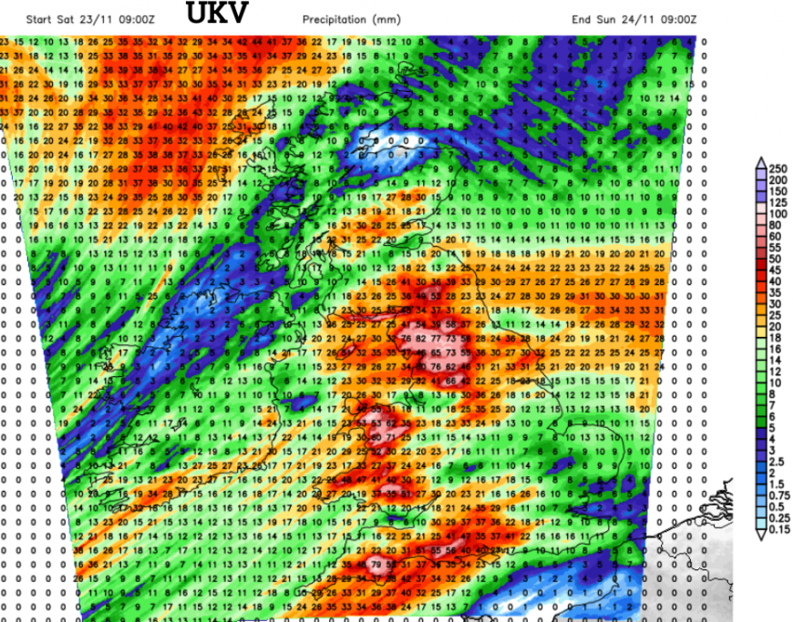
Heavy rain from Storm Bert will cause travel disruption and the risk of flooding
London
Before dawn eastern and SE England will be quiet with light winds. Through the morning the southerly wind will freshen and the rain will arrive. This will be patchy for London and the Home Counties on Saturday but heavier towards Hampshire and SW England. It will feel cold early on but by the end of the day, temperatures should have risen to 12C in a blustery southerly wind. However, there will be further bursts of rain during the afternoon and evening. Southeast England isn’t going to feel the brunt of Storm Bert but it will be quite a change from this week and just because double-figure temperatures are showing, it may not feel so mild for Saturday night.
Sunday in the south
The cold front will still be working its way over England on Sunday. Southern England will see more rain with a blustery S/SW wind and gales around the coasts near Dover. Kent could be bright but windy as the frontal rain band brings heavy rain in a line from southwest England across to East Anglia on Sunday afternoon. This band could be further southeast or more patchy but bear it in mind as it could bring further heavy downpours.
Loading recent activity...