


It was very wet last weekend and into the early part of this week across parts of England, central parts of England saw a month’s worth of rain in less than 12 hours, with thunderstorms on Sunday moving slowly north across Bedfordshire locally dumping over 100mm of rain in a few hours, which lead to localised flooding, travel disruption and later lead to rivers in the area to burst their banks.
Further persistent rain affected further west across the south Midlands, parts of the West Country and central southern England on Monday, bringing localised flooding and a thoroughly miserable day. However, Tuesday was a drier day for many.
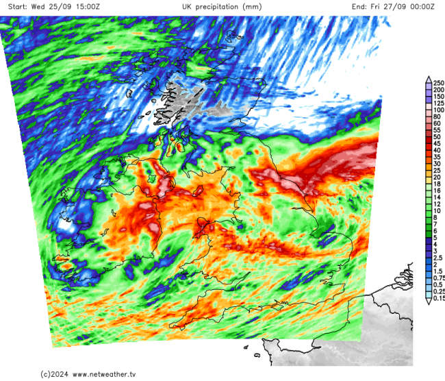
But the drier respite yesterday and today will be short-lived, with the next band of rain already sweeping in from the west this afternoon, reaching eastern areas through the evening. This rain will clear away north and east from much of England later this evening, but will linger across northern England into Thursday, thanks to the occluded front bringing the rain stalling here before drifting south later on Thursday. There is a Met Office yellow rain warning in force from midnight tonight to midnight Thursday night for NE England:
Accumulative rainfall until midnight on Thursday
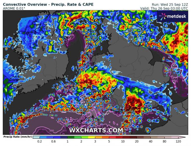
Further south following this evening’s rain clearing east and waiting in the wings to the west, a quite potent shortwave trough lurking out over the Atlantic will zip across southern Britain through the early hours of Thursday – bringing an area of quite heavy rain and showers, perhaps with thunder towards the south coast and maybe inland across southern counties. The rain associated with this disturbance could be locally torrential and so may lead to localised flash-flooding and exacerbating already high river levels in parts of southern England following a lot of rain recently and the saturated ground it’s led to.
3am Thursday morning and some areas of heavy and perhaps thundery rain moving across southern areas
Netweather have issued a Thunderstorm Watch for tonight - with mention of localised flooding and perhaps an isolated tornado:
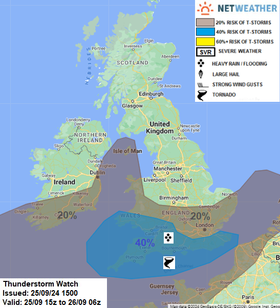
Tonight’s expected heavy downpours moving east across southern areas do not have a warning in force by the Met Office. But there is a yellow rain warning in force from 5pm tomorrow until 10am Friday. This is for bands of heavy showers developing along a sharp wind shift moving slowly south over England tomorrow evening and night along with a band of rain along an occluded front pushing down from northern England. Some deep convection is possible, particularly along the wind convergence zone shifting south, with thunder and lightning possible along with locally intense rainfall leading to flash-flooding. Some uncertainty where is most at risk in a broad area from south Wales across southern England and Midlands to East Anglia. But at the moment it looks like south Wales across the Midlands and southern England to the north of the M4 corridor look most at risk from these torrential downpours. Same areas that saw a lot of rain on Sunday and Monday past.
More rain on the way for the rest of the week, especially England and Wales, but high pressure builds this weekend bringing drier and more settled conditions
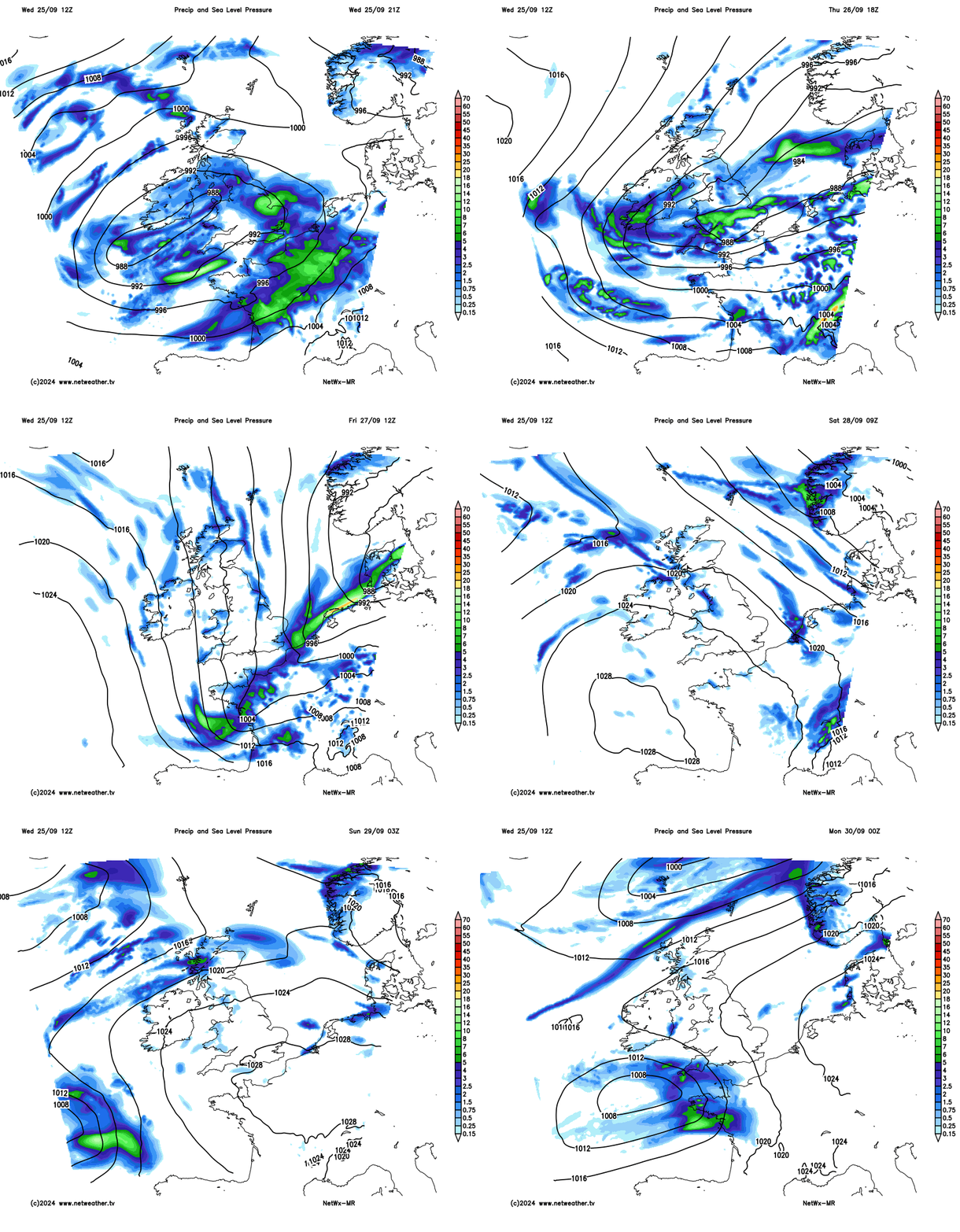
Most of Scotland and Northern Ireland will see some rain, but generally any rain won’t linger for long with the story more of sunshine and showers.
Overnight rain across southern Britain should clear the south coast by Friday breakfast time, followed by a northerly wind pushing Arctic air southwards across the whole of the UK. This will mean it will feel colder than of late, with maximum temperatures below below average for the time of year – reaching 9-13C a best. Friday night will be cold too, with a touch of frost possible in rural areas.
Temperatures 6am Saturday
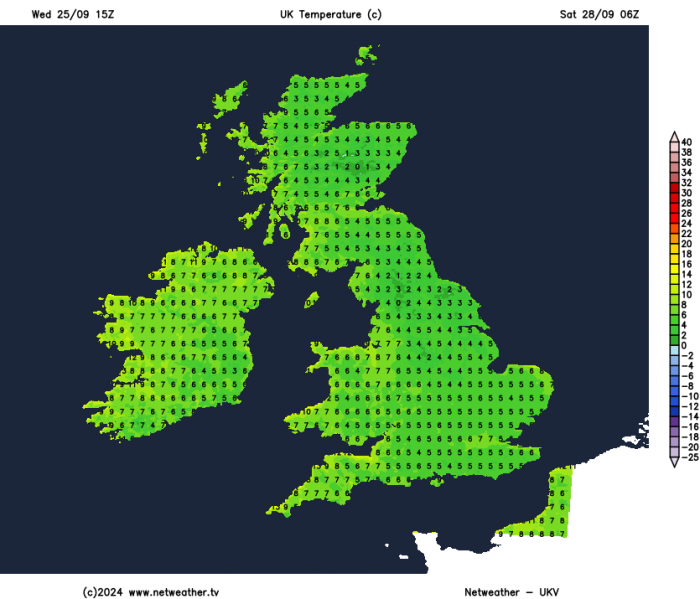
A chilly start to Saturday and remaining on the cool side through the day, temperatures reaching 10-12C in the north, 12-14C in the south, but with a ridge of high pressure building in, it will be mostly dry with sunny spells away from coasts in the northwest, which will see some showers. Another chilly night into Sunday, temperatures widely falling into single figures, perhaps low enough for a rural ground frost in sheltered areas.
Another mostly fine, dry and sunny day on Sunday, with high pressure hanging on. Though late in the day, it may turn wet and windy in the far southwest.
There is a great deal of uncertainty, with models diverging on developments off the Atlantic associated with a strong jet stream running in close to the south. But there is potential for a deepening low moving across southern England on some models, while other have the low going across northern France. So there is a risk of wet and windy conditions to start next week across southern areas.
Loading recent activity...