Summer 2024 has been notably cool, contrasting sharply with the warmth of early May. Westerly and north-westerly winds have dominated since June, bringing temperatures more reminiscent of past decades. While some warming is expected, forecast models now suggest any significant pattern shift may be brief and limited.
Summer 2024 has been somewhat odd so far. While June and the start of July would not have been unusually cool had they been slotted into the 1960s, 1970s or 1980s, it has certainly been very cool by recent standards, and it has particularly stuck out relative to the warm first five months of 2024.
With a record warm May, with the warmth especially concentrated early in the month, and then a slightly cooler than average June and a somewhat cooler than average start to July, temperatures overall have not warmed substantially since early May. This is particularly unusual, for in most parts of the UK, normally we would expect daytime maximum temperatures to be 5C or more higher in early July than in early May.
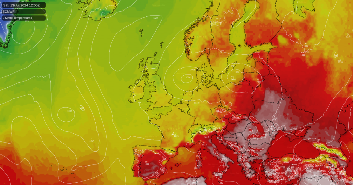
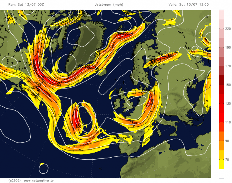
It is a stark reminder of the variability that we can experience in the British climate on top of the underlying warming trend. The first five months of 2024 were often dominated by a weather pattern with blocking highs to the north of Britain, especially around Greenland, but also a strong jet stream running across the country and low pressure often centred to the west and south-west of Britain, bringing frequent warm southerly and south-westerly winds but also frequent cloudy and wet weather associated with low pressure systems and fronts. Combined with the recent run of record warm global temperatures, this resulted in very warm but often cloudy and wet weather.
Since early June, the weather patterns have shifted and we have often seen low pressure dominating from Greenland across to Scandinavia, but with the jet stream often diving south-eastwards as it heads into north-western Europe.
This has resulted in Britain seeing predominantly westerly and north-westerly winds, which tend to bring cool weather at this time of year. It also resulted in rather drier weather during June, although into early July the wet weather has returned for much of the country. Perceptions of a poor summer so far have been reinforced by the frequency of rain, rather than the quantity: it has mostly been a case of frequent light rain, and weather patterns featuring short, sharp showers and thunderstorms have been comparatively rare.
The recent cool weather has also been assisted by relatively low sea surface temperatures to the west of the British Isles. For much of 2023, sea surface temperatures were record warm in this region, and this meant that when we got frequent westerly and north-westerly winds during July and August 2023, they were not especially cold, and cool days were generally offset by warm nights. The relatively warm seas to the west of Britain also contributed to the very wet July that most of us had in 2023. Cooler seas to the west have resulted in similar weather patterns bringing cooler temperatures in June and early July 2024, and have also contributed to it being rather less wet than July 2023 was, albeit due mainly to less intense rainfall, rather than less frequent rainfall.
The medium range forecast models have progressively shifted away from suggesting a significant pattern change for the second half of July. Until a few days ago, there was quite strong support for high pressure to break off from the main Azores anticyclone and to settle over central Europe, bringing Britain much warmer weather via southerly and south-westerly winds. This looked like it might persist for at least a week, and there also looked to be potential for high pressure to move closer to Britain later in the month, which would mean increased chances of most regions becoming predominantly dry and sunny as well as warm.
However, today's model outputs are now suggesting just a weak, short-lived ridge of high pressure moving into central Europe between 18 and 21 July, with Britain seeing just the occasional short-lived ridge, followed by the return of westerlies and low pressure starting around 21/22 July. This can be seen as the "summer warmth/heat" equivalent of what we often see in winter when northerly winds are forecast: sometimes the medium range forecast models will predict a prolonged spell of northerly winds with high pressure over Greenland several days out, and then when we get nearer the time, the duration of the predicted northerly is reduced to just two days or less, resulting in just a brief and half-hearted cold snap.
It is still looking highly probable that the second half of July will be somewhat warmer than the first half, but it is increasingly looking likely that it will not become substantially warmer than average. This means that on the whole, the calendar month of July 2024 is looking increasingly likely to be on the cool side, especially relative to recent years. Comparisons can be drawn with July 1998, which was another summer when we were coming out of a strong El Nino, and it was another example of a generally cool and cloudy month with frequent westerly and north-westerly winds. There is potential for the back end of July 2024 to see a similar shift to what we saw for August 1998, with high pressure ridging into the south more frequently and producing generally warmer and sunnier weather, but at present it is looking set to be rather cloudy and cool in the north for much of the rest of July 2024.
Loading recent activity...