A windy weekend. There will be more rain but Storm Kathleen is mostly about gales and gusts. Saturday brings a bonus bit of warmth for part of the UK.
Storm Kathleen will bring a sliver of warm air on Saturday and a windy weekend. There will be more rain, because every day in the UK seems to need just a bit more rain. However, Kathleen is a windstorm named by Met Eireann with the most impactful winds expected over Ireland.
“Storm Kathleen will bring gale force southerly winds, with some severe and damaging gusts.”
It is still Easter holiday time for many schools with people travelling. The ground is sodden, so trees could come down with the risk of power outages and there are concerns about large waves along some coasts. There are yellow wind warnings for Northern Ireland, southwestern Scotland and the Central Belt with all the western counties of England and Wales.
“Southerly winds are expected to gust quite widely to 50-60 mph on Saturday, while some exposed spots, particularly in Northern Ireland, will see gusts to 70 mph with large waves also likely.” Met. Office
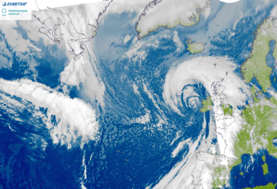
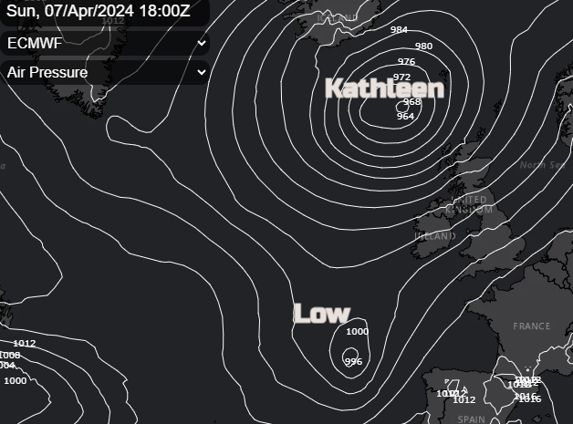
The Kathleen low pressure has a classic Norwegian cyclone structure with warm front rain pushing northwards during Friday night. Behind this, many towns will have a very mild night with temperatures around 11 to 13C. The cooler easterly flow will cling on in the far north until the warm front rain clears on Saturday morning.
The warm sector air will reach from northern Africa, all the way to the UK on Friday night. If the timings were a bit slower then Saturday would feel warm for more of the UK and for longer, but it doesn’t quite coincide with maximum daytime heating. East Anglia, Lincolnshire and Cambridgeshire look to be the warmest places.
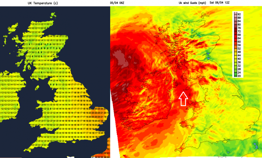
The showery fragmented cold front starting over western Britain on Saturday morning will move eastwards during the day, mostly as a band of cloud. Ahead of this, it looks like eastern England should reach the high teens, even into the low twenties Celsius around lunchtime. Cooler air will follow so it’s a specific window of warm air on Saturday and not for everyone
Heavy showers will appear for Northern Ireland and western Scotland closer to the low centre and something more lively is showing for SW Britain during Saturday evening. By day on Saturday, there is hope for good spells of fair weather when it shouldn’t feel cold, it could be bright even sunny but will be windy. Don’t cling too much to the exact timings of showers and the dry interludes at this point. The output on weather apps or location forecasts will highlight a risk of showers but not an exact downpour. You might need to keep an eye on the radar on the day for the progress of those.
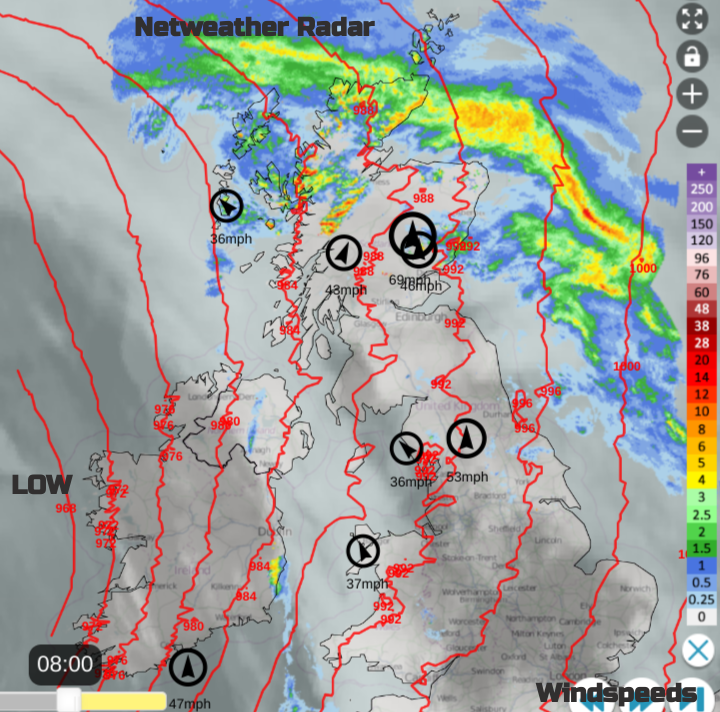
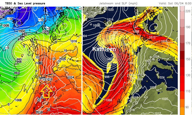
Netweather Radar Sat 8am showing IR satellite, rainfall radar, top windspeeds and model isobars
Friday saw colder air over Scotland ahead of the frontal bands, resulting in snow in the easterly flow. Norhtern Ireland and for Wales, England and Scotland south of the Central Belt, there is milder air with brisk southwesterly winds. These will be gusty for Irish Sea coasts, the Welsh Mountains and the Peak District up into the Pennines today.
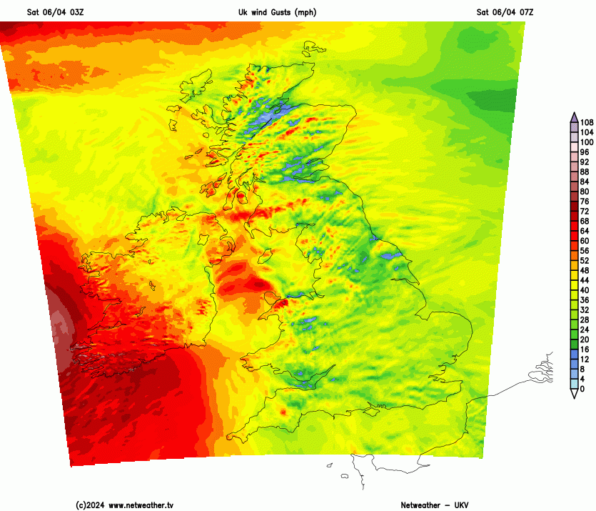
The southerly wind will freshen for Britain on Friday night with gusts of 60mph around the Irish Sea, for the high ground of western Britain and over Northern Ireland. The main focus of gales and severe gales will hit the west and south coasts of Ireland on Saturday morning. There will be strong winds up the Irish Sea which could impact ferry services with southerly gales forecast by late morning up into the North Channel. The severe gales will move by NW Ireland as the very windy weather sets in for Northern Ireland, Gwynedd, the Isle of Man and more of Scotland and the far north of England. It will be a windy day everywhere.
 The focus of the southerly gales will be closer to the Western Isles by early Sunday morning as the rest of the UK continues with windy conditions and impacts from the strongest winds and gusts. Clusters of heavy showers will work their way across the UK. One through Saturday night from the southwest up to northeast England and further bands early on Sunday over Wales and across to eastern Scotland. Sunday will be blustery but bright with fair weather for London and the Home Counties and the scattering of showers elsewhere.
There are concerns about coastal and tidal flooding through the weekend as the strong SW winds push a surge onto the coasts with large waves. Overtopping and spray are likely at high tide for exposed areas. Another low pressure will be heading our way on Monday and that could bring more heavy rain and blustery winds.
The focus of Kathleen’s heavy rain will be along the warm front on Friday night through Ireland, Northern Ireland, the Irish Sea and then northern Britain early on Saturday, heading northwards. The warmest region looks to be eastern England on Saturday around the middle of the day. Storm Kathleen’s winds will be the most impactful part, although there are ongoing issues with standing water, runoff and localised flooding. There will be high gusts over hills and mountains, particularly in the west, with a wider risk of gales, even severe gales for Ireland, Northern Ireland, western Scotland and through the Irish Sea.
Top satellite image Norwegian Met Institute
Loading recent activity...